Following historic wildfire disasters in Southern California, a statewide dry spell intensifies and extreme fire weather conditions persist in the south
Remarkable wet-to-dry transition combined with extreme downslope wind event yields dual wildfire catastrophes in SoCal
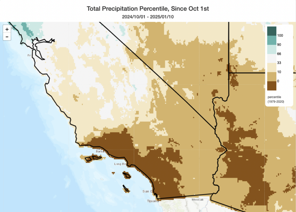
It’s never good feeling when a dire weather or disaster risk prognostication comes to fruition; that “pit in your stomach” sensation has been described by many meteorologists, climate scientists, emergency managers, and disaster-focused researchers over the years. It certainly encapsulates how I’m feeling this week in the wake of the dual wildland-urban fire catastrophes that have unfolded this week in Los Angeles. The precipitating weather event–a particularly extreme and widespread downslope windstorm that ultimately brought wind gusts as high as 80-100 mph even at some lower valley locations as a result of pronounced “mountain wave” activity–was extremely well predicted (and advertised) in advance. So, too, were the risks posed by increasingly extraordinary antecedent climate conditions consisting of two extremely wet SoCal winters (which facilitated abundant “fine fuel” grass and brush growth), then periods of record heat (from summer into fall) and finally the driest start to the rainy season on record (though early January)–which set the stage for the extreme windstorm to push fires igniting in or near the wildland-urban interface well into populated neighborhoods (and even through commercial areas and downtowns) of suburban LA.
As the full scope of the disaster becomes clearer, the Palisades and Eaton fires in Los Angeles County are (as of this writing) confirmed to have collectively destroyed over 12,000 structures and killed at least 16 people–and both tolls are expected to rise further. These two fires together are now almost certain to become the costliest on record, and perhaps could even become so individually. Around 200,000 Californians remain evacuated at this time, with millions more indirectly affected by air pollution from residual smoke. The fallout from these disasters will reverberate throughout California, and beyond, for years to come.
Long-duration elevated to critical fire weather conditions to persist in SoCal this week (and possibly beyond)
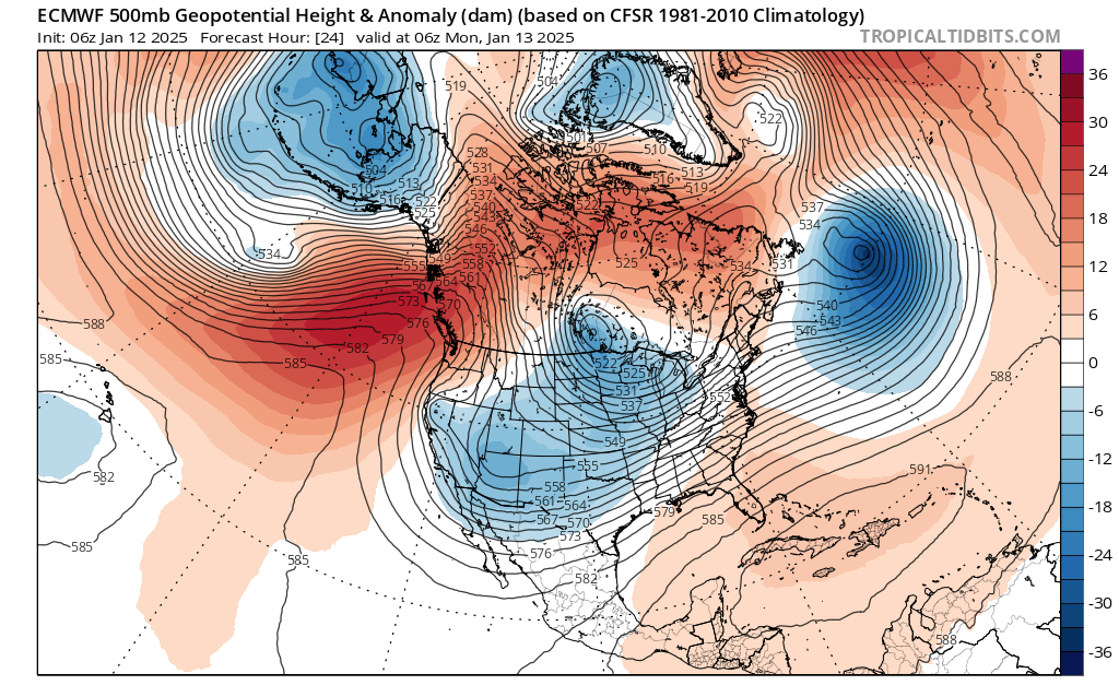
I sincerely wish I had better news to report on the weather front, but alas…the current outlook suggests little if any relief for the foreseeable future. In fact, Santa Ana/offshore winds will likely re-strengthen further this week with a continuation of bone-dry conditions through at least Thursday or Friday. Therefore, a long-duration elevated to critical fire weather event will continue/re-develop this week across a wide swath of Southern California. I do not expect it to be as extreme as the peak of last week’s event (fortunately), but this reduction in peak intensity will be partially offset by the long duration and also the cumulative fuel drying that has occurred over this now days-long period of very low humidity and strong winds in many areas.
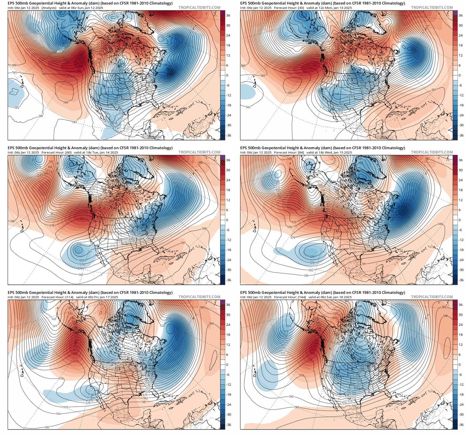
This week, another “retrograding” (i.e., “westward against-prevailing-flow-moving”) low pressure system will move across California. It will not, unfortunately, bring any precipitation; it will, however, once again set up a surface pressure gradient favorable for strong offshore winds across a broad swath of Southern California for several days in a row (Mon to Wed-ish). The airmass during this period will remain very dry across SoCal, too, with relative humidities commonly being under 20% and locally 10% or lower at times.
At higher elevations more susceptible to strong Santa Ana winds, peak winds during the upcoming event could even approach the very strong levels we saw during last Tue/Wed’s event. However, it is very unlikely that lower elevation valley areas will see winds nearly as strong as last week’s exceptionally strong gusts that pushed the Eaton Fire into Altadena. Such winds on the mountaintops are not as rare as when they occur at lower elevations; they will still pose an extreme fire weather threat where they occur, but hopefully somewhat less of a threat to the densely populated urban fringe of LA.
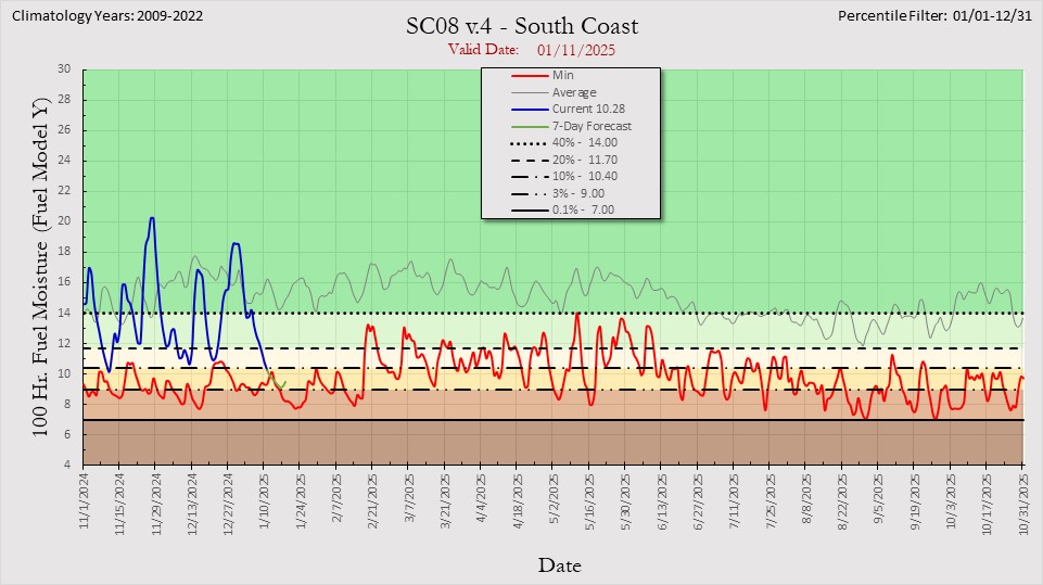
Why will these winds be very strong at higher elevations but not so extreme at lower ones? With this event, there is much weaker upper-level jet support (i.e., winds aloft are dramatically weaker)–and there will also probably not be a major vertically-propagating mountain wave event this time around (so it will be harder for winds aloft to make it all the way to the surface in the valleys). Still, given what has recently transpired and that fuel moistures continue to plummet in heavier fuels in higher mountain areas as the “atmospheric blowdrier” conditions persist, this will be a potentially dangerous period once again for fire risk across much of Southern California. Though the intensity of peak risk will not be as high as last week, it will also be longer in duration and more widespread; this will pose a risk that new fire starts will spread rapidly (and that any flare-ups on existing fires, which today at least look much quieter than recent days, could do so as well).
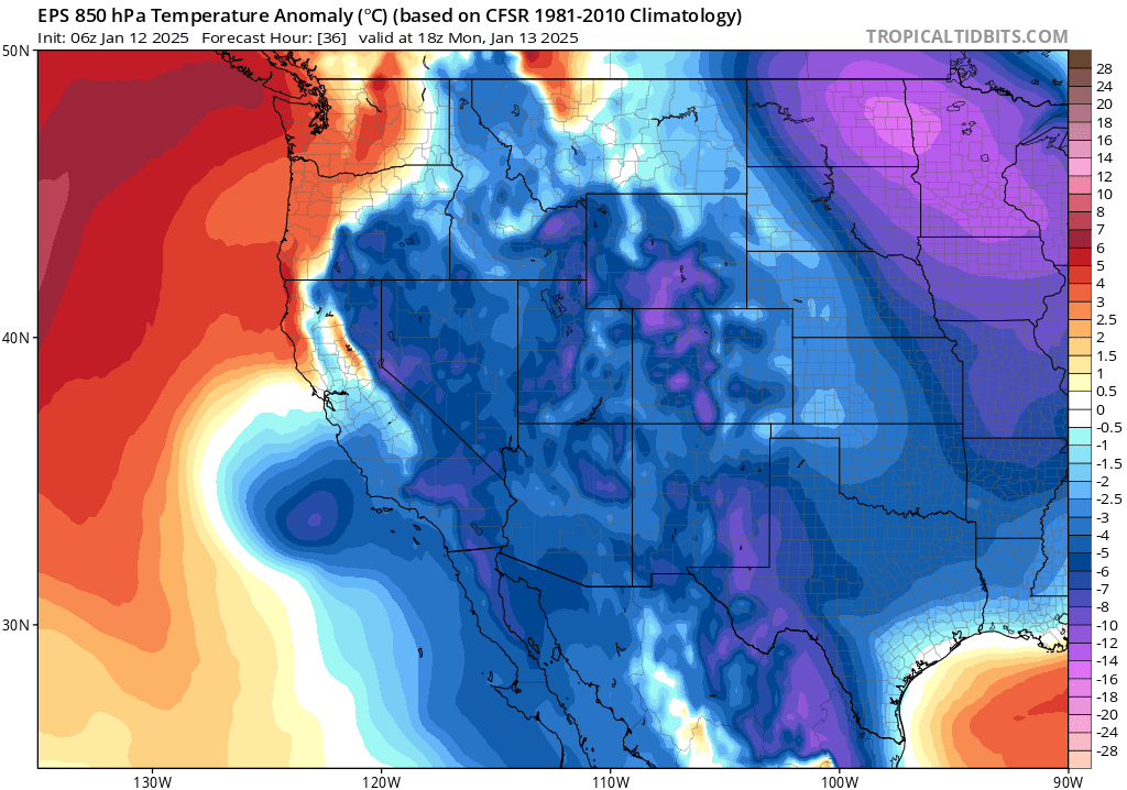
Notably, these upcoming wind events will be colder than recent ones; temperatures throughout Southern California will trend toward below average during this period (with subfreezing conditions in the mountains and higher valleys at night; this could pose a challenge for the thousands of firefighters working outdoors during this period and for the tens/hundreds of thousands who could be affected by either preemptive or damage-induced power outages during this period).
Remarkably persistent dry pattern (albeit cooler) to likely continue across CA & West coast into late January
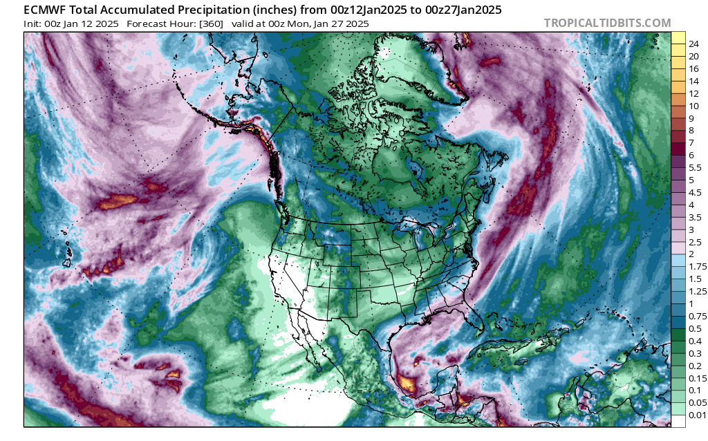
So far, for the Water Year to date, there has been (as previously noted) a remarkable spatial “precipitation dipole” across California, ranging for much wetter than average conditions in the north to record dry in the south. While the cumulative dipole persists, the next 1-2 weeks appear to be more equitably dry statewide–with little prospect for meaningful precipitation anywhere in CA for the next 10 days and perhaps longer. A persistent ridge of the northeastern Pacific will take on a more northeast-southwest “tilted” orientation–allowing a steady stream of “inside slider” low pressure systems to bring periodic offshore wind/elevated-to-critical fire risk conditions across SoCal. At this time, there appears to be multi-model ensemble consensus that this generally dry and “inside slider-y” pattern will continue for the next 10-14 days. This will likely push SoCal even further into “record dry start to the Water Year” territory, and result in a seasonal deficit that will be difficult to recover in Feb-Mar/Apr (so the risk of longer-term drought re-developing across SoCal and the interior Southwest will increase, as noted this autumn was a distinct possibility for the 24-25 season).
A few additional notes
Also, I am still trying to coordinate a dedicated blog post to cover our recent review paper on increasing hydroclimate whiplash on a warming Earth–a publication that was, in an extraordinary and eerie coincidence–published this past week. I have delayed this post, both given the scope of this immense disaster and the precedence of communications surrounding the immediate response and also because I have been so pressed for time. I will still try to release this within the coming week, if at all possible (stay tuned).
Finally, I know there are likely long-time members of the Weather West community who have been directly affected by these fires. Although I usually enforce a fairly strict “on topic” policy in the Weather West comments section to keep the discussion there focused and constructive, I wanted to emphasize that any posts on the topic of disaster relief and/or resources available to those affected are explicitly deemed “on topic.”