Another NorCal heatwave next week, but progressive pattern continues
A very warm spring across California and Southwest

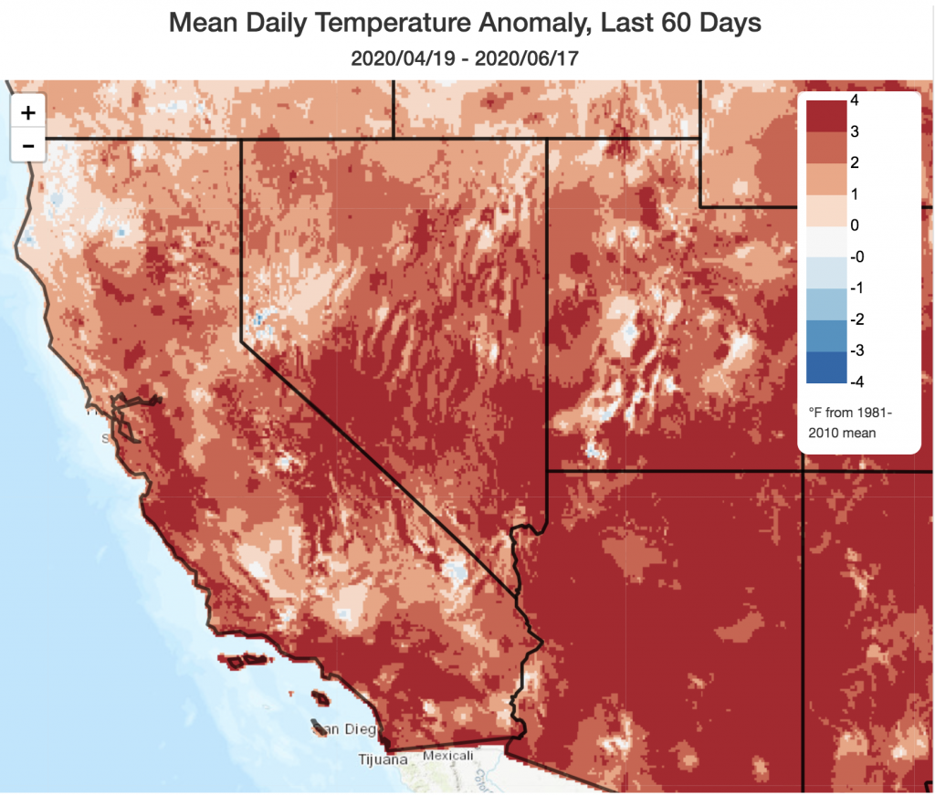
California has experienced an unusually high number of early-season heatwaves already this season. More commonly a season of “May Gray” and “June Gloom” due to a persistent and chilly marine influence, coastal California in particular has experienced temperatures well above average over the past 60 days or so. There have been some cool spells and even some late-season precipitation interspersed between these heatwaves, but the overall effect has been to produce well above average temperatures overall across nearly the entire state this spring. The hotter-than-average conditions were even more pronounced across a wide swath of the interior West and Southwest over the past couple of months–persistent, anomalous warmth that is now contributing to a very severe wildfire season in Arizona and New Mexico. Numerous large fires are currently burning across the region amidst unusually warm and dry conditions leading up to the onset of the summer monsoon–which probably won’t arrive in earnest for at least a couple more weeks. Until widespread monsoon thunderstorms arrive later this summer, the wildfire situation in this region will continue to be quite serious. It’s worth noting that wildfire season in the Southwest usually peaks much earlier than in California (June-July vs. Aug-Oct)–so the early severity of the fire season there may offer something of a preview of what’s to come later this summer in the Golden State.
Another heatwave next week, mainly in NorCal

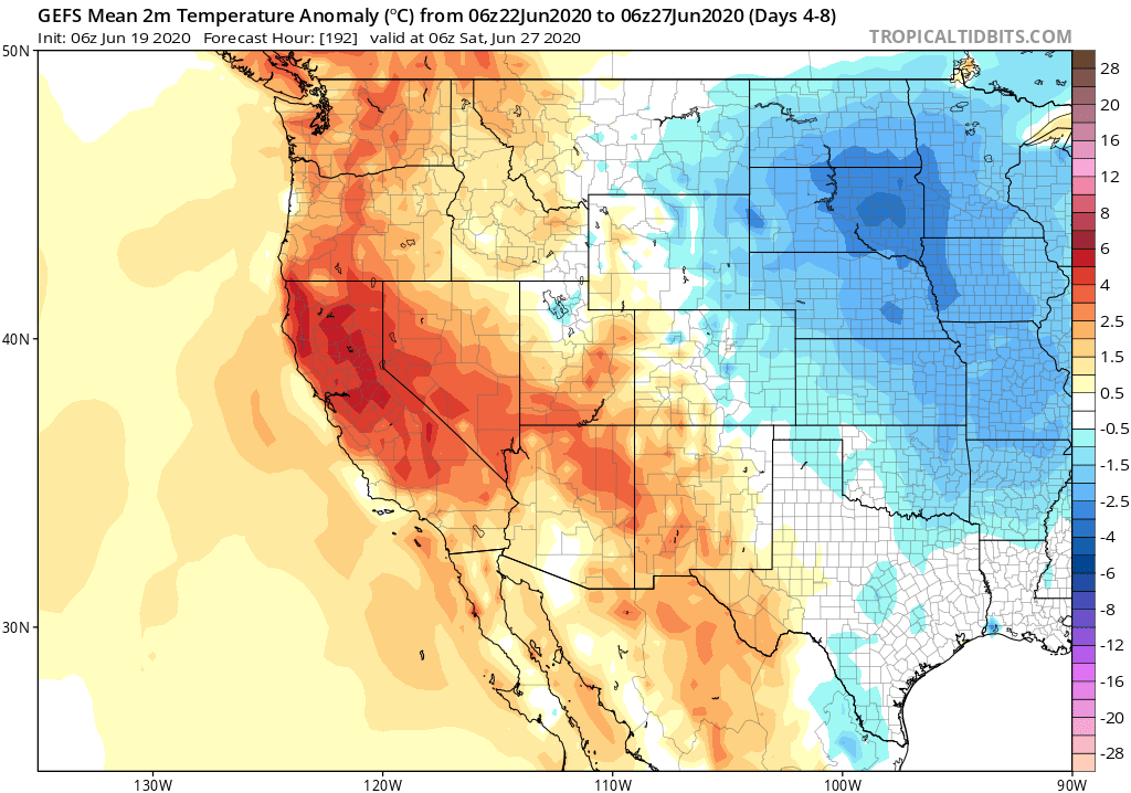
After our recent cooldown, yet another heatwave now appears to be on tap for California next week. While this one might not break as many records as some of the events earlier this spring, it will continue to push the monthly and seasonal average even further above average. Widespread triple-digit heat will probably occur across the Sacramento Valley and other inland areas–and a fairly prolonged stretch of uncomfortably hot conditions is likely away from the immediate coast. The coming heat will probably be most pronounced in NorCal (vs. SoCal), and may come in two waves (one earlier next week, and one later next week, although there may not be much of a break in the Central Valley). Fire weather concerns will be elevated due to the heat and dryness, although winds should remain pretty modest and that will probably preclude extreme risk conditions over the next week or so.
Unusually progressive summer pattern continues, with cooldown toward end of June
The good news about the upcoming heat is that there’s already a pretty clear end in sight during the last few days of June. Model ensembles suggest that a weak trough will replace the strong ridge over California about 9-10 days from now–resulting in a major cooldown, windier conditions, and perhaps a few isolated mountain showers. This cooldown represents the continuation of a familiar “progressive” pattern over the past couple of months–whereby strong ridging aloft is consistently (if temporarily) replaced by modest troughing shortly thereafter. This is somewhat unusual for the time of year, given that the Pacific jet usually becomes less active by this late in the season
Looking ahead: a hot July, and what about La Niña

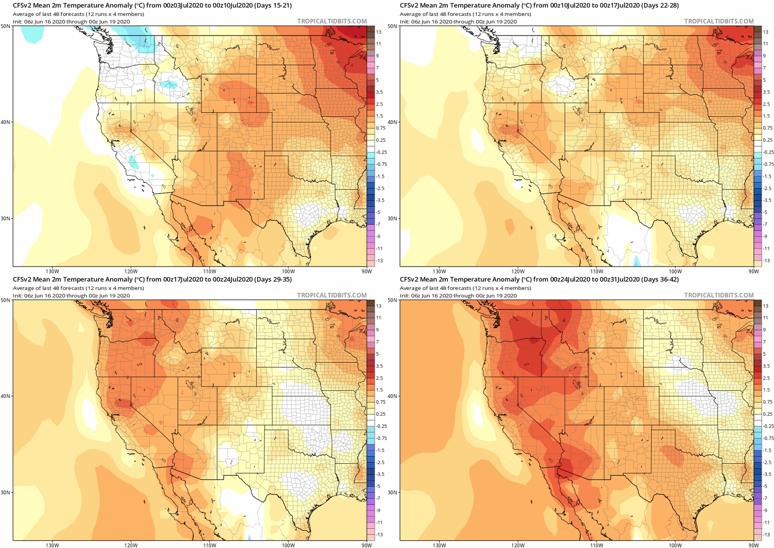
After the late June heat reprieve, what next? At the moment, all odds point to an unusually hot month ahead. Sub-seasonal models are currently suggesting that temperatures may start out near average across California in early July but will subsequently become more anomalously hot as the month progresses. In fact, the official monthly outlook from the CPC presently suggests that odds favor a hotter-than-average July across virtually the entire continental U.S.–most pronounced across the West. This “hot summer” signal has been pretty consistent in seasonal outlooks for the past couple of months, and it’s looking increasingly likely that it comes to pass. It’s worth noting that these seasonal outlooks and global forecast models often don’t resolve the cooling influence of the marine layer along the immediate CA coastline in summer–so it’s possible that we could have another summer with extremely hot temperatures across the CA interior but less remarkable warmth closer to the ocean. We shall see.
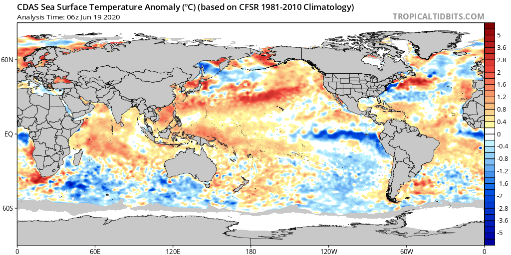
And what’s going on in the tropical Pacific Ocean at the moment? Well, there’s currently a pretty conspicuous region of cooler-than-average water in the key ENSO region–surrounded on nearly all sides by warmer than average water (including the water along most of the California coast). That does have the early appearance of developing La Niña event–and, indeed, there have been hints of a trend toward La Niña in the dynamical forecast models for several months now. At the moment, it’s still not clear whether this potentially incipient La Niña event will actually come to fruition by next autumn/winter, which is when it might exert a stronger influence on California weather. For now, it remains a bit of a waiting game. We’ll probably have a better sense by late July or August what we can expect.

On extreme event attribution and climate change: how does the science work?
My colleagues and I were recently asked to compile an overview of the emerging sub-field of climate science known as “extreme event attribution” (EEA). The overall goal of EEA is to formally and systematically quantify the ways in which climate change is affecting the frequency and characteristics of extreme weather and climate events using a combination of observations from the real world and simulations from process-based climate models. EEA can help scientists approach questions like “Is global warming increasing the severity of Western U.S. fire seasons?” or “Was the extreme storm surge caused by Superstorm Sandy amplified or made more likely be climate change?”
If you’re interested in learning more about EEA, and the successes so far plus the major challenges that remain, our recently published primer in One Earth is aimed at a fairly broad but scientifically-inclined audience (which I think encompasses many, if not most, readers of this blog!). A Twitter thread summarizing our piece is below, but you can also access this article directly (and freely, as this is an open access paper) by visiting: https://www.cell.com/one-earth/fulltext/S2590-3322(20)30247-5
Another NorCal heatwave next week, but progressive pattern continues Read More »