12/5/2013 Update regarding low elevation snow potential
The ongoing Arctic outbreak across the western United States is still on track to allow for exceptionally low snow levels in California later Friday into Saturday across all of Northern California. Precipitation will begin on the North Coast during the daytime and spread southeastward towards the Bay Area by evening as a weak low pressure area slides down the Pacific Coast. This system, though barely visible on satellite imagery this evening, is currently producing snow along the Washington and Oregon coastlines.
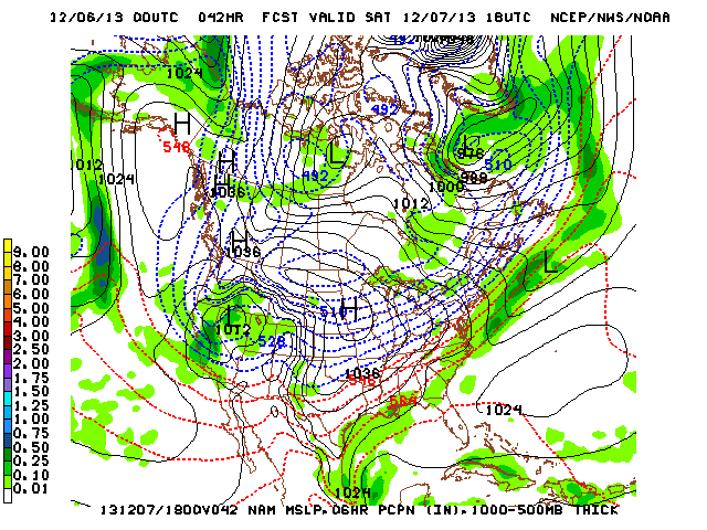
Snow levels may be near sea level initially on the North Coast, and while accumulations along the immediate coastline are unlikely, flakes could fall on the beaches near Eureka and Arcata. The system will be moving into a very dry continental polar airmass over California when it makes its approach on the Central Valley, and dewpoint depressions will be very steep. This will allow for strong evaporational cooling as the atmospheric column moistens at the onset of precipitation, likely bringing snow or a rain/snow mix all the way down to the Sacramento Valley and San Joaquin valley floors (under 500 feet). Above 500 feet or so in this region, accumulating snowfall is likely overnight Friday into Saturday morning. Accumulating snowfall is also possible on Saturday morning at even lower elevations in the far eastern Sacramento and San Joaquin Valley, where an inch or two could fall down to 200 feet or so. In the Bay Area, conditions will not be quite as favorable as in the Central Valley, but while precipitation will probably start out as rain under 2000 feet snow levels will drop quickly on the back end of the precipitation band associated with the cold front, possibly bringing some snow accumulations down to 1000 feet and a brief rain/snow mix to even lower elevations. In addition, frontal lifting may be strong enough to generate some weak convective activity near the frontal boundary, which could produce an isolated thunderstorm or grapuel/hail down to sea level just about anywhere. There is some uncertainty regarding how long showers will linger behind the front. If any persist into the late afternoon or evening, they will likely fall as snow.
This system has the potential to produce snow in parts of Northern California that very rarely see it. While I certainly don’t expect widespread images of iconic Northern California landmarks buried in the white stuff, many Northern Californians may be in for a pleasant surprise when they wake up on Saturday morning. Stay tuned, and post any photos of unusual snowfall to Weather West’s Facebook page!
——————————————————————————————————————-
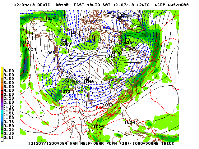
12/3/2013 Update regarding potential for very low snow levels this weekend
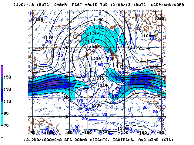
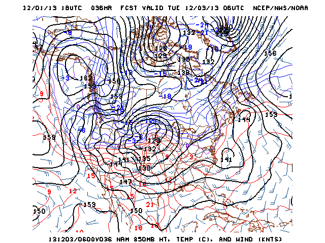
A small low pressure system is now expected to develop near the Washington state coastline on Thursday and swing southward down the Pacific coast into Northern California on Friday. This system would be fairly unremarkable, bringing only light to moderate precipitation, if not for the very cold airmass in which it will be situated. The trajectory of this system suggests that there won’t be strong enough southerly winds to scour out the existing cold air, and that the easterly flow on the north side of the system may be able to wrap some even colder air over Oregon into the circulation. While it’s too early to know exactly how this event will unfold, current model solutions suggest that snow levels Friday into Saturday may drop below 1000 feet across much of Northern California. It’s not entirely out of the question that some snow could even fall closer to sea level, especially in the Central Valley. Certainly a system to keep a close watch on over the next few days!
——————————————————————————————————————-
Recent weather summary
Unusually dry and stable conditions continued through the end of November across most of California. November precipitation was well below average, especially in the northern part of the state where precipitation was limited to essentially one modest storm event around the middle of the month. Warm conditions are currently being experienced as mild offshore flow and persistent geopotential height ridging allow for a weak storm track across the Eastern Pacific.
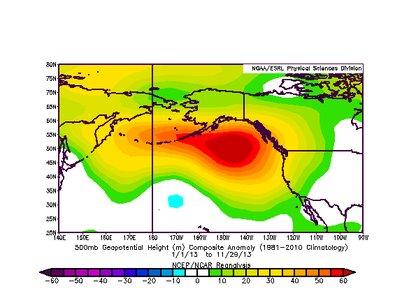
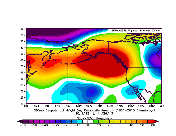
Above: geopotential height anomaly for calendar year 2013 (left) and Nov. 2013 (right)
I had an extensive discussion on the meteorological characteristics of the current year-long California dry spell in an earlier blog post. A quick check of recent data suggests that the same spatial pattern of anomalously strong geopotential height ridging in the Gulf of Alaska continued through the month of November and will proabably continue for at least a while still. In fact, over the past 30 days the amplitude of the pattern appears to have further increased, with a very high amplitude ridge extending well north over Alaska. This highly-amplified north-south oriented flow pattern will be a major factor in the upcoming Arctic outbreak over the western half of the United States.
Dramatic change in the short term: much colder conditions, though little precip
The aforementioned high-amplitude ridging in the Gulf of Alaska and the associated “blocked” flow over the Pacific Ocean has led to an accumulation of very cold air on its downstream side over western Canada. As the entire pattern shifts slightly westward (retrogresses) this week, this modified Arctic airmass will be able to spill southward and even slightly westward over the West Coast and intermountain states.
The initial push of very cold, modified Arctic air will be associated with a sharp cold frontal boundary that will sweep south from the Seattle area tonight to the San Diego area by Wednesday. This front is rather impressive dynamically but very moisture-starved, so precipitation associated with it will be quite light south of the Oregon border. While scattered showers are possible for a brief time this week in most parts of California, only very light accumulations are expected and some places may see no precipitation at all. Noteworthy, however, will be the rapidly falling snow levels that will be associated with any precipitation that does occur–by Wednesday morning, snow levels should fall to 1500 feet or below in the north and 3000 feet or below in the south. Snow levels will really plummet on Thursday, but all precipitation will have exited the region by then.
By Thursday, an exceptionally cold airmass will be in place across nearly the entire Western United States. Projected temperature anomalies are very impressive for early December, and could potentially be record-breaking. Sub-freezing daytime highs are possible in Washington and Oregon, including Seattle and Portland. Long-duration hard freezes are expected across a large portion of California, with daytime highs struggling to reach 50 degrees even near the coast. While it’s still a bit early to tell how low overnight minima may go late this week, it’s entirely possible that some colder valley locations near sea level will fall below 20 degrees. Overall, this airmass appears to be as dry as one might expect for a cold continental source region, though it’s possible that very weak disturbances in the flow could being a few snow showers to unusual locations along the West Coast next weekend. In any case, this appears to be a pretty long-duration cold event, as the GFS/ECMWF ensembles keep a very cold and dry pattern entrenched for the next 8-9 days at least.
Is there any hope for rain?
We’ve now entered December, and the rainy season in California should be in full swing. As most of us have become acutely aware by this point, the prevailing pattern has been exceptionally stable and dry. While the impending cold snap represents a large change in the sensible weather, the overall large-scale pattern that’s allowing it to happen is actually not very different from the one that has been so persistent for nearly the past 12 months.
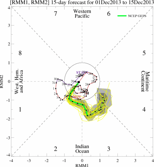
Typically, a blocking ridge as strong as the one projected for this week is eventually undercut by strong westerly flow as the flow pattern becomes increasingly unstable, which either collapses the blocking pattern or allows a low-latitude storm track to develop (which would be favorable for California precipitation). There are early indications that this could occur in 9-12 days as the blocking pattern finally breaks down, though uncertainty regarding this potential evolution is enormous. One argument in favor of California finally seeing some meaningful storm activity by mid-December is increasing activity of the Madden-Julian Oscillation in the West Pacific. This mode of intra-annual tropical atmospheric variability is strongly associated with California rainfall events when its active phase shifts eastward, as is currently being suggested by dynamical model forecasts. For now, we’ll just have to wait and see if this comes to fruition: this persistent ridging has thus far been seemingly impervious to previous attempts to knock it down, so it’s possible the models are being too aggressive with its demise. We’ll know more in a week.
© 2013 WEATHER WEST
Discover more from Weather West
Subscribe to get the latest posts sent to your email.