June 2021 hottest on record for interior CA (but not coast)

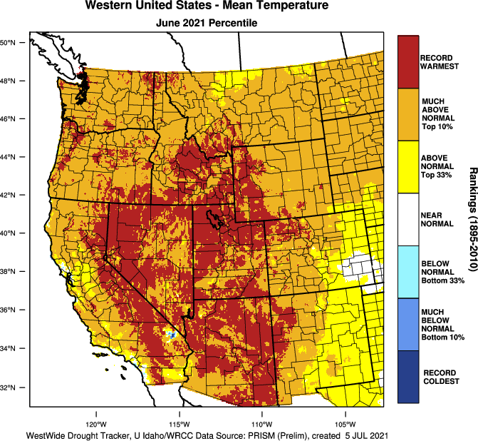
June 2021 was a month to remember in California…if you happen to live outside the densely populated coastal cities from the Bay Area south to Los Angeles. In marine-influenced zones, June was a relatively unremarkable month–with a robust marine layer bringing periods of cool temperatures and coastal drizzle. But in dramatic contrast with these near-average coastal temperatures, inland portions of California (including the Sierra Nevada & foothills as well as the SE deserts) suffered through what turned out to be the singularly hottest June in over 100 years of record keeping. In fact, a very large fraction of the interior West experienced its hottest June on record–mainly the result of all-time record breaking heat during the first part of the month in the Southwest, then the all time record-shattering heat in the Pacific NW later in the month. Throughout 80-90% of the land area of the American West, June 2021 will be remembered for quite some time for its extreme heat, unless you (like most people in California) live near the coast. This is a pattern we’ve seen occur somewhat frequently in recent years, with searing heat inland yet quite mild conditions where the marine influence hangs on, and which also makes for a rather strange reality where CA may have experienced its hottest June on record overall (see NOAA’s official numbers out tomorrow) despite most *people* in California experiencing a relatively comfortable month. This pattern may protect the immediate coast yet again during the upcoming heatwave, though this protective influence may be slight weaker than earlier in the summer due to warming coastal SSTs (and often disappears by early autumn, in any case, when coastal CA tends to see its hottest annual maximum temperatures in most years).
Yet another major heatwave will affect most of interior CA, but will largely skirt coast

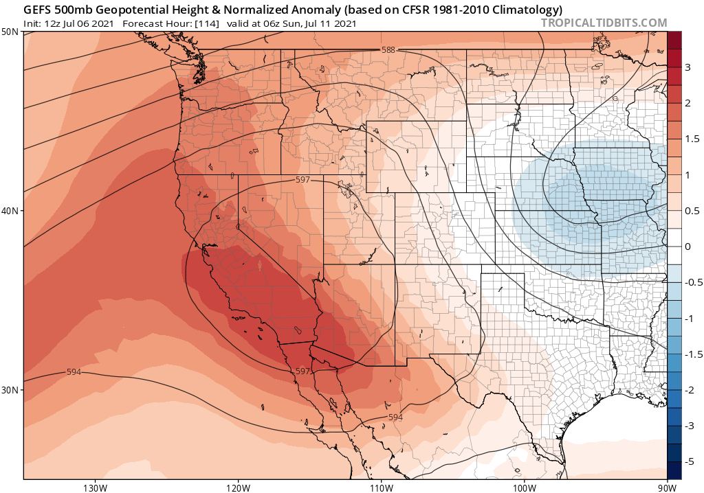
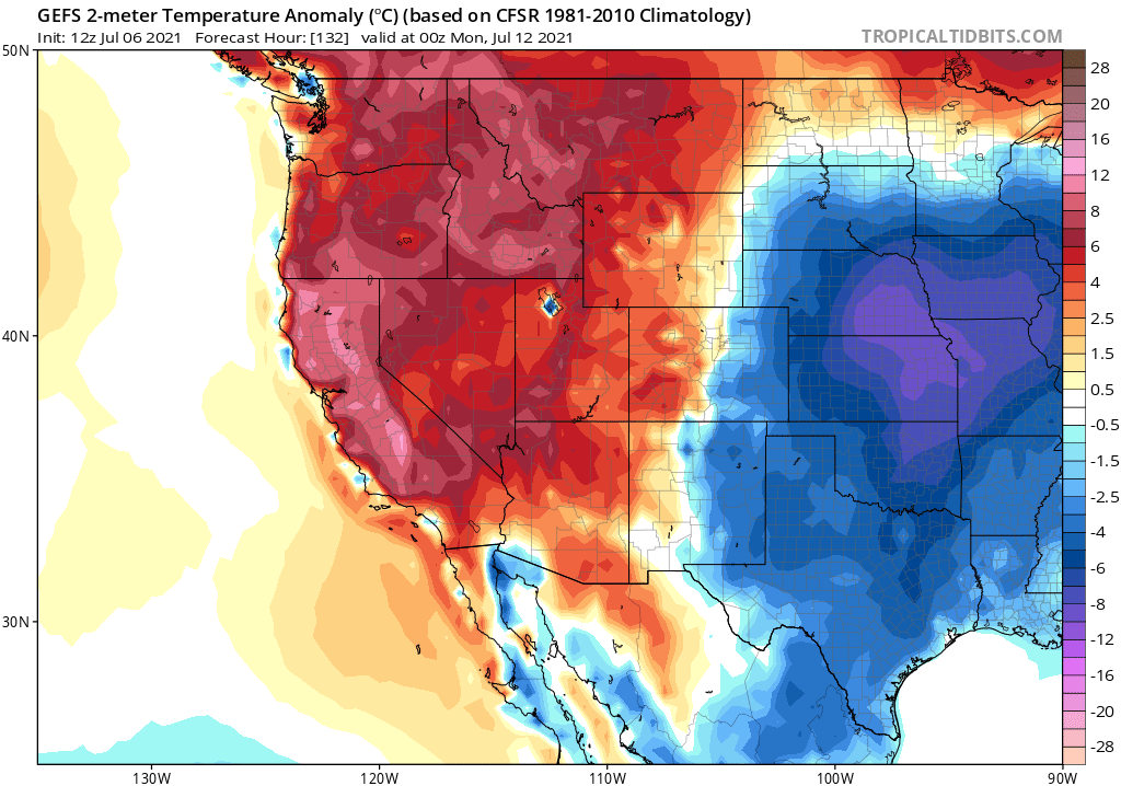
As noted above, the recent pattern seems likely to continue: record heat inland, but remarkably unremarkable temperatures along and near the coast. Another strong ridge will build in later this week across eastern California and Nevada–bringing hotter than average July temperatures once again to a broad region stretching from the Pacific NW to Arizona. Unlike the last event, which baked the Pacific Northwest with almost inconceivably hot temperatures, this event will be somewhat weaker and primarily focused on California. But many places in the Central Valley (especially the far northern and far southern portions) as well as the Sierra Nevada and western Nevada will nonetheless experience heat that will likely meet or break daily records, and could even approach monthly/all-time records yet again in a few spots.
It is worth noting that the surface temperatures currently being projected by both the GFS and ECMWF operational runs still appear to be biased too high in places like the Central Valley (they are currently showing all-time records for most Central Valley cities this weekend, despite a large-scale pattern that does not really appear to support them). That adds some additional uncertainty to the forecast for this weekend, but at this time I don’t expect widespread 115+ temps in the Central Valley as is currently being depicted by explicit model output (though a few places could get that high, and daily records are still likely). The NWS has already issued Excessive Heat Watches for the entire Central Valley and much of the higher elevation CA and NV interior for the coming event.

This type of heatwave, with a strong “heat dome” aloft associated with a hot mid-level airmass building in from the southeast, tends not to be conducive to extreme coastal temperatures in CA–and this event is unlikely to be an exception. It may get a bit warmer at the beaches than usual this weekend, but much of the SF Bay Area and the more coastal portions of the LA/San Diego metros (i.e., where most Californians live) will be warm to hot, but nothing too extreme. This is because there just isn’t enough offshore flow to overcome the strong marine influence this time of year and to fully suppress the marine layer.
Not much change in the long-term outlook
To the extent that there is (modest) seasonal predictability of summertime temperatures in California, nothing much has changed in recent days: there are continued signs for above-average temperatures across most of the state for the rest of the summer and autumn, especially away from the immediate coast. Of note is that there are no longer any major monsoonal surges on the immediate (1-2 week) horizon–though that can (and most likely will) change at some point later this summer. Ocean temperatures are no longer cooler than average along the immediate CA coastline (generally somewhat close to the recent long-term average for early July), so I would expect there to be a continued modest marine influence during heatwaves for at least the next few weeks. It will be interesting to see how the late-season, more coastally-focused heatwaves behave later this season (Aug-Oct) given how extreme temperatures have been inland so far this summer. Wildfire activity has remained relatively quiet in near-coastal areas so far this season, though has recently picked up steam in far NorCal (mainly Shasta, Siskiyou, and Modoc counties thus far)–entirely consistent with predictions of an especially severe fire season that would primarily get underway beginning in July-August and peak in the autumn in coastal areas.
Discover more from Weather West
Subscribe to get the latest posts sent to your email.