NorCal thunderstorm outbreak likely this week; significant fire weather concerns
An unusually active August weather pattern will bring thunderstorms to northern and central California this week. A quasi-stationary cut-off low pressure area, currently centered several hundred miles southwest of San Francisco, will deepen somewhat over the next few days. While the low itself is relatively devoid of moisture, fairly strong and deep southeast flow on the eastern side counterclockwise circulation will advect a considerable amount of monsoonal moisture into California from the desert southwest and Eastern Pacific.
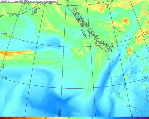
A persistent area of upper-level divergence will be in place over much of the northern half of the state from late Sunday through at least Wednesday, and lapse rates will be relatively high for this time of year given the presence of some cool air in the mid-levels. All these ingredients will likely combine to produce a fairly widespread convective outbreak for much of California, including the lowlands of the Central Valley and the Bay Area. In fact, one of the only regions likely not to see convective activity at some point this week is the Southern California coastal areas. Some thunderstorms could develop as early as late Sunday, and storms through Monday night will probably be pretty dry as the lower levels of the atmosphere moisten. As a result, there is a high fire weather threat until at least Tuesday, and given the near-record to record dry state of the fuels in Northern California this summer, even the wetter storms that occur from Tuesday through Thursday could still lead to new fire starts.
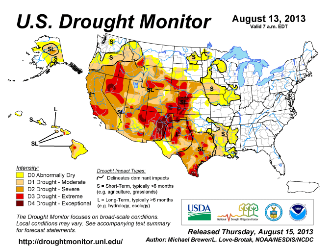
Long-term drought continues to intensify over California; no strong precipitation signals for fall/winter 2013/2014
Two consecutive dry winters in California–including two seasons during which extraordinarily long dry spells occurred in the middle of the wet season–have led to increasingly severe drought conditions. The most recent update of NOAA’s Drought Monitor now depicts “extreme” drought conditions–the second most severe category–over a large portion of Central California, with virtually the entire rest of the state experiencing “severe drought.” Given the long duration of California’s characteristic dry season, there’s little chance of mitigating these drought conditions before the late fall and early winter.
Since it’s now mid-August, it’s reasonable to start considering whether there are any indications that the upcoming wet season might bring above or below-normal precipitation and either mitigate of worsen the ongoing drought. This year, unfortunately, there are few indications that winter 2013/2014 will bring relief from the recent dry spell. El Nino/Southern Oscillation (ENSO) conditions in the tropical Eastern Pacific Ocean are presently in neutral territory and are projected by both dynamical and statistical models to stay that way through the winter. One caveat is the existence of a rather large subsurface pool of warm water that could potentially surface in the coming months, but we’ve seen a similar situation several times over the past decade and in none of these instances has El Nino developed subsequently this late in the year.
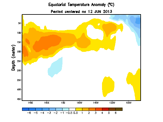
There is also a rather large pool of warm sea surface temperature (SST) anomalies in the North Pacific at the present time, and if these persist they could lead to a negative PDO-like response for the West Coast of North America (that is, an increased potential for below normal precipitation). Since ENSO is the best predictor for California cool-season precipitation and because there’s no strong ENSO signal at the present time, it’s pretty difficult to make any meaningful statement right now about expectations for California winter precipitation this year.
But in the meantime, enjoy the thunderstorms!
© 2013 WEATHER WEST
Discover more from Weather West
Subscribe to get the latest posts sent to your email.