After a period of unseasonably moist and unsettled conditions across the West (including California) last week, the entire western third of the North America is currently in the midst of a very intense and record-breaking heat wave. Daily and June monthly high temperature records have already been exceeded by very wide margins in numerous locations (including, notably, Las Vegas and Death Valley), and all-time record highs are currently in jeopardy as this extremely impressive event continues to intensify. There is actually a chance that the temperature in Death Valley later today could approach the highest-ever reliably measured surface air temperature on Earth (134 F)!
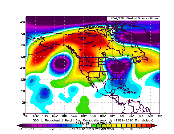
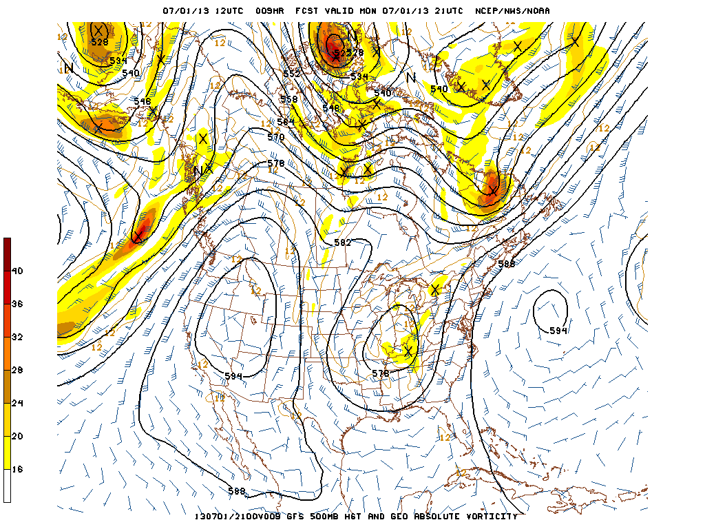
What is causing the present extreme heat across Western North America? The answer is quite clear after taking a look at the large-scale flow pattern. A remarkably persistent and very high amplitude ridge has been in place over the Western United States for several weeks, with anomalously deep troughs located on either side of the ridge over the Eastern Pacific and in the vicinity of the Great Lakes. This pattern has been very persistent and already brought extreme weather to nearly all of North America during the month of June, with all-time record high temperatures in Alaska, tremendous flooding in Alberta, Canada, anomalous West Coast summer rainfall, many consecutive days of flash flooding and severe thunderstorms along the Eastern Seaboard, and (of course) our current record-breaking heatwave in the American West. This stagnant yet highly amplified pattern is very unusual for summer, and the subsequent seasonally anomalous clash of air masses will continue to produce highly significant weather events over North America for the foreseeable future.
This heat wave has already been ongoing for several days, and may not reach peak intensity in some regions (especially on its western periphery) until Tuesday or Wednesday this week. There is unlikely to be rapid relief from the heat on the back end of this event, as well; in fact, after some modest cooling for the second half of the week, it’s possible that the extremely large and powerful ridge will once again gain amplitude going into next week. Additionally, the present heat is not an especially dry one by Western U.S. standards–dewpoints in Central California are in the upper 50s and lower 60s F, which means that the apparent heat is actually quite close or even slightly above the actual temperature. This is somewhat unusual for California and the interior Western deserts, where the “dry heat” is usually more tolerable than equivalently high temperatures in other parts of the world with more lower atmospheric moisture. There are two primary reasons for this: first, in California, last week’s anomalous rains added an unusual amount of ground-level moisture over a large region; and second, the anticyclonic flow around the powerful region of high pressure centered over the Great Basin is favorably aligned for the northward advection of mid-level monsoonal moisture from the Gulf of California. Due to the duration, intensity, and non-dryness of the present heat wave, conditions will continue to be quite dangerous in some reasons for at least several more days.
In addition to the heat, a considerable amount of mid-level monsoonal moisture is streaming northward around the west side of the massive high pressure area sprawled over the interior West. With the extremely high surface temperatures currently being experienced in many regions, it won’t take a particularly strong trigger mechanism to produce some elevated convection over much of California over the next few days. Mainly dry thunderstorms are possible in some areas, which would greatly enhance the already extreme fire weather conditions in place nearly statewide. I also wouldn’t be entirely surprised to see some thunderstorm activity in some unusual spots, such as the SF Bay Area or the LA Basin over the next few days given the monsoonal moisture trajectory.
The primary blocking ridge over the Western U.S. is unlikely to be dislodged from its current position for quite some time. Numerical models currently depict a continuation of the prevailing longwave pattern for at least another couple of weeks, which means continued heat and monsoonal moisture surges out West. It’s possible we could see more record-breaking heat at some point in the next two weeks once again with this same pattern, but that remains to be seen. Stay tuned!
© 2013 WEATHER WEST
Discover more from Weather West
Subscribe to get the latest posts sent to your email.