Wet season precipitation to date: far below average
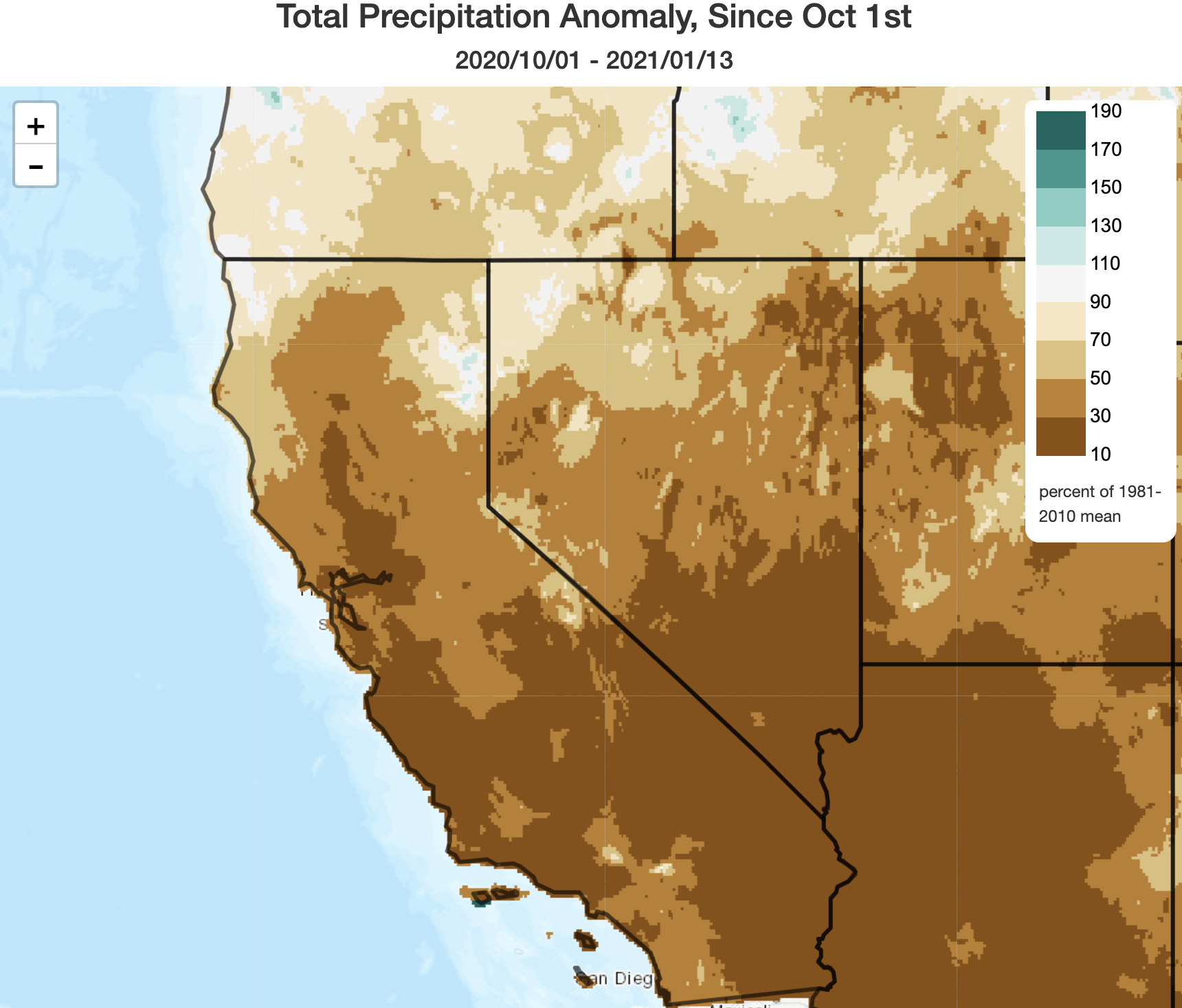
Few readers will be surprised by the fact that the 2020-2021 Water Year to date has been rather dismal, precipitation-wise, throughout California. Nearly the entire state (with the very localized exception of a few spots in far NorCal within 50 miles of the Oregon border) is running more than 50% behind typical values for the season to date–and much of the state has seen less than 30% of average. Snowpack has now fallen below 50% of average on a statewide basis. In recent days, unusually warm temperatures have been the rule across much of California, and summer-like afternoon temperatures into the 80s and 90s have been widespread in SoCal. Wildfire activity has once again picked up in the southern third of the state, in conjunction with renewed offshore winds and unusually dry mid-winter vegetation conditions.
Highly amplified flow pattern = a challenging and variable forecast
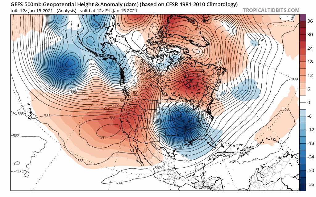
The overall pattern over the American West over the next 7-10 days is going to be highly “amplified”–meaning there will be an unusually high degree of “meridional” (north-south) upper atmospheric flow. The absence of a more typical zonal (west-east) pattern means that individual weather systems will tend to “meander”–yielding a very tricky weather forecast that numerical models will likely struggle to fully capture until the last minute.
That said: here’s what I think is likely to happen. A strong West Coast ridge, which has been responsible for the record heat across SoCal in recent days, will persist through the weekend. More unusual warmth is expected statewide today through Sunday, before cooling begins on Monday. By later Sunday, however, a strong “inside slider” low pressure system will dive almost due southward over the Great Basin and move over inland SoCal by Monday. By later Tuesday, this low may even “retrograde” (move westward) slightly–positioning itself over the ocean to the southwest of San Diego.
Strong offshore winds through Tuesday; SE desert rains possible
This low pressure system will generate a very strong offshore-directed surface pressure gradient beginning Sunday and persisting into at least Tuesday. Strong offshore winds are therefore expected to develop over the hills and mountains of NorCal on Sunday, then spread to SoCal on Mon/Tues. In SoCal, these winds will be much more widespread at lower elevations than in NorCal due to strong cold advection and downward momentum transfer. While this event is still several days out and uncertainty remains, certain model runs are suggesting the potential for a widespread high-end and possibly damaging wind event across SoCal during this period. Some typically windy areas could see gusts well in excess of 70 mph–and even normally wind-sheltered spots could see substantial gusts.
What about fire weather concerns? Well, they are clearly going to be quite high across SoCal as vegetation is currently very dry for the time of year. Elevated to critical fire weather is expected across most of SoCal during this period, and there is a significant risk of major wind-driven fire events. Red Flag Warnings will likely be in effect for a 2-3 day period, and the risk will likely be higher than this past week.
What about NorCal? Well, the synoptic *weather* pattern is indeed one conducive to very high wildfire risk across the Sierra western slopes and in the Bay Area. However, the saving grace this time may well be the minimal (but not zero) precipitation received thus far this season from about the SF Bay Area northward. Despite large accumulated precip deficits, there has been just enough soil moisture to allow for initial vegetation green-up. This will likely prevent the Sun-Mon wind event from becoming a critical/extreme fire event in NorCal, since the vegetation is not *nearly* as dry as it would be closer to the peak of fire season. For the reason, we likely will not see any Red Flag Warnings in NorCal from this event. That said, things are still probably dry enough to support some modest level of fire activity under strong wind conditions. So while the risk will *not* be comparable to extreme fire events earlier in 2020, it will certainly be higher than typical for mid-January in northern California.
By later Tuesday, the cut-off low pressure area southwest of San Diego may be able to generate some precipitation on its far eastern flank. Upslope flow on the *eastern* flanks of the SoCal mountains, especially across the far south (mainly San Diego County)–could generate some precipitation in the normally very dry southeastern deserts of CA. I don’t expect any of this activity to make it over the SoCal mountain crests to the coast (except perhaps for a shower or two near San Diego), but in this kind of pattern there’s always a slight chance of surprises as far north as about Los Angeles. Any rainfall outside of the SE deserts should be minimal, however, and would likely arrive after the primary wind/fire weather event.
Major pattern shift still expected in 5-7 days: colder, and likely wetter
There is some good news on the horizon. I’m increasingly confident that all of California will experience a major pattern change during the last week in January, and that it will strongly favor colder and wetter conditions. As I mentioned in the last post, a major stratospheric warming and subsequent polar vortex disruption event occurred this month. At the time, it was unclear whether the subsequent “atmospheric stirring” effect would favor continued ridging/dry conditions over CA, or would help shake things up in a manner favorable for wetter conditions. Well, it now appears that the latter outcome is going to come to fruition.
How is this likely to evolve? Well, the persistent West Coast ridge isn’t going to disappear entirely. Instead, it’s likely to retrograde westward over the next 7-10 days–eventually moving far enough westward to allow a modified Arctic airmass to take hold over the Pacific Northwest and allowing colder/unsettled conditions to prevail over CA.
Now, the details of this pattern are still very uncertain. But I would expect nearly the entire state to see substantial precipitation toward the end of January, and for the Sierra Nevada to see some rather substantial snow accumulations. These are the kind of cold/unstable systems that have a tendency to bring low snow levels and some convective activity (isolated thunderstorms/localized small hail), so there may be some good cloud watching mixed in as well.
All in all: this looks like a highly beneficial pattern change on the horizon. But in the meantime…hold on to your hats!
Discover more from Weather West
Subscribe to get the latest posts sent to your email.