Record-dry start to “wet season” in some places

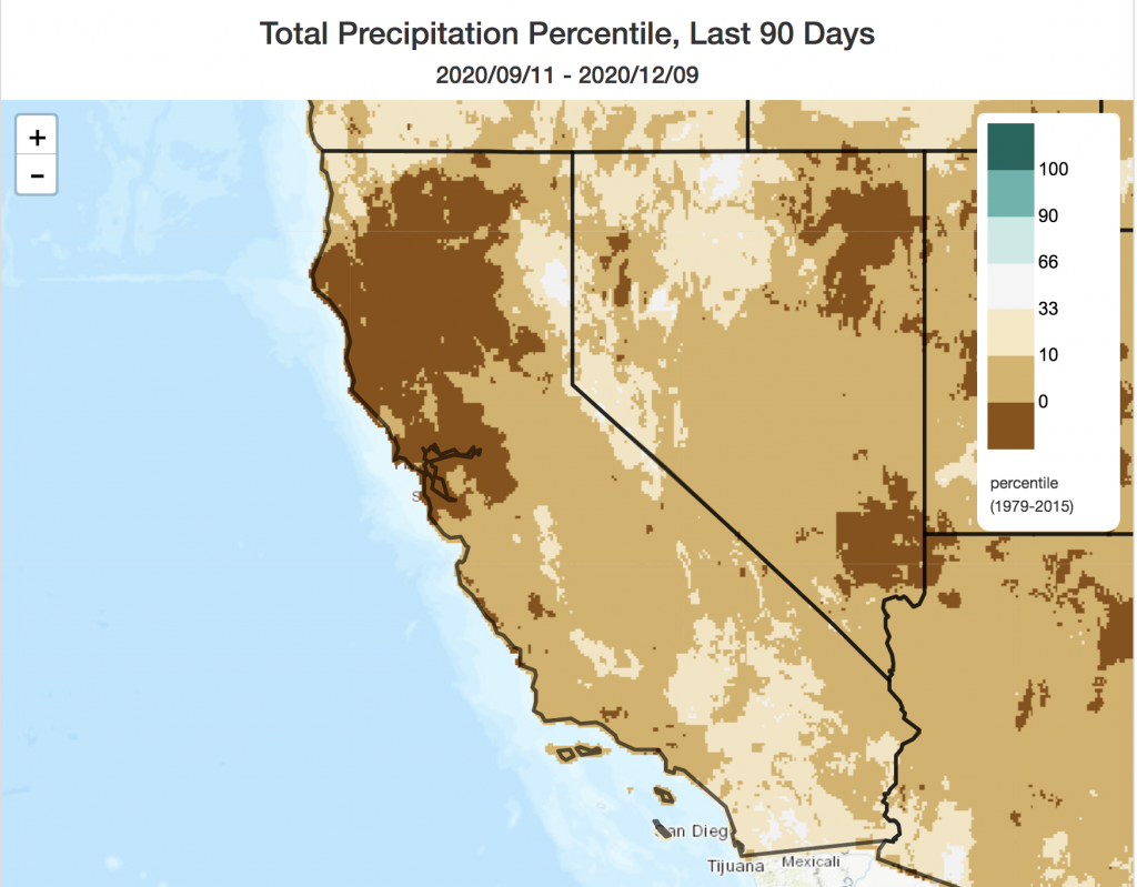
It will come as a surprise to absolutely no one in California that 2020 has brought a pretty abysmal start to the rainy season. The formal stats certainly bear that out: most of NorCal has experienced its driest Sep-Dec-to-date period since at least the 1970s, and some spots are experiencing a record-dry start to the season. SoCal did see a bit of additional early-season rain weeks ago, but even down south things are now far drier than average for the date. Offshore wind events recently have produced extreme fire risk and even a limited number of large fires south of Santa Barbara–a trend that will likely continue during offshore wind events for the foreseeable future.
Autumn-like pattern next 7-10 days: some rain and snow north, but dry south
A fairly long-advertised, though modest, pattern change is currently on NorCal’s doorstep this afternoon. In fact, light showers have already begun to fall in some areas ahead of an incoming cold front later tonight. The good news is that these initial light showers will be the first of several episodes of light to moderate precipitation across NorCal over the next week or so. Widespread rain and mountain snow is likely at times from approximately the I-80 corridor northward (or perhaps a bit south of that). Outside of the North Coast and orographically-favored spots of the northern Sierra western slopes, however, total precipitation accumulation over the next 10 days or so does not look very impressive for mid-December. It will certainly be enough to dampen lingering fire risk from about San Francisco northward, but likely still won’t be enough to get the rivers and streams running more than a trickle in most places.
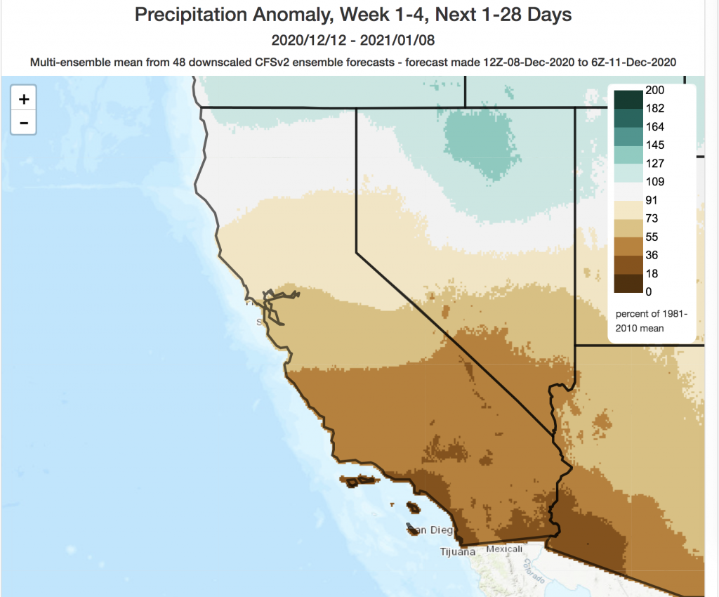
In fact, multi-model ensembles are currently suggesting a fairly underwhelming pattern change. Precipitation over the next 2 weeks, while non-zero and welcomed, likely won’t even be enough to keep pace with average precipitation during December–meaning that seasonal deficits will actually continue to grow across all but the northernmost sliver of CA in the coming days. Right now, there appears to be little (if any) chance of measurable precipitation across the southern 1/3 of California for at least the next 2 weeks.
Still no game-changing shifts on the horizon through January
Looking even farther out in time, there still isn’t a great deal of good news to report. A moderate to strong La Nina event continues in the tropical Pacific, the North Pacific is (once again) record warm, and the western tropics are also very warm. As I’ve previously discussed, that just isn’t a great combination if one wants a wet California winter.
The just-released multi-model ensemble seasonal/sub-seasonal outlooks continue to suggest an elevated risk of drier-than average conditions across California during January, especially across the southern 2/3 of the state (far NorCal near the Oregon border stands the best chance of a near-average January).

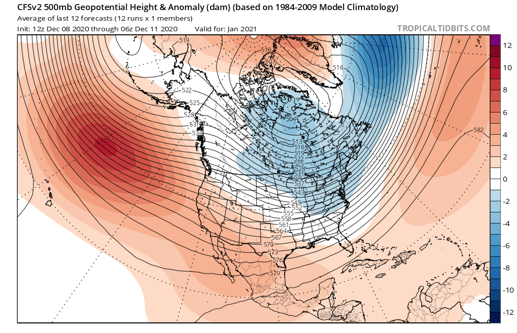
For the rest of winter beyond January, I suspect the overall large-scale pattern over the northeastern Pacific is going to look pretty familiar: a strong, persistent ridge is likely to remain semi-permanently anchored off the West Coast, deflecting the jet stream and primary storm track to the north of CA. Occasional opportunities for precipitation (especially cold/snowy systems over the Sierra) will periodically occur as this high pressure system is occasionally suppressed to the south and west, although that’s not really a recipe for drought-busting, moisture-laden atmospheric rivers. (That’s not to say it can’t happen, but the monthly/seasonal mean pattern certainly isn’t looking conducive for it.) This is why I’m still pretty confident that much of California will see a substantially drier than average Water Year in 2020-2021.
I am somewhat more optimistic that the “back half” of the season (late Feb through April) may feature some more widespread precipitation as La Nina weakens, and as the background climatology shifts (“back-weighted” winters do seem to have a tendency to occur in California), though it’s unlikely that we’ll come close to making up the accumulated seasonal deficit (which looks like it’s already going to be fairly large by mid-late Dec). So if you’re in NorCal: enjoy the rain this coming week! And if you’re in SoCal: hopefully I’ll be able to offer a more optimistic outlook in the next update.

Discover more from Weather West
Subscribe to get the latest posts sent to your email.