Wildfire situation remains serious, despite improved weather conditions

Well, the best news I have to report is that the “second wave” of widespread dry lightning I discussed in the last post was–to a large degree–“a bust.” Dry lightning did occur, but it was focused mainly across inland portions of California (vs. the coast), and the number of strikes was only in the low hundreds (vs. nearly 15,000 during the mid-August event). As a result, only a few new fires were sparked (rather than hundreds), and existing fires were not substantially exacerbated. This is one time I’m very glad the stated 1-in-3 chance that it would fall apart actually came to pass!
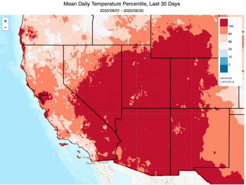
Since then, conditions have remained warmer than average inland but have cooled to near-average levels near the coast, with the return of a fairly robust coastal marine layer in NorCal. This has benefitted firefighting efforts on most of the extremely large wildfires ringing the San Francisco Bay Area in particular. On most of these fires near the Bay Area, the risk of further property damage or loss of life has dramatically decreased relative to two weeks ago. On the other hand, however, fires farther north and east across interior California continue to spread very aggressively and in some cases largely unchecked. As a result, vast areas of smoke and poor air quality continue to persist.
Just for some additional perspective: approximately 1.7 million acres have now burned statewide since the beginning of the calendar year–the vast majority of that in northern California, and mostly within the past 3 weeks. If the fire season ended today, that would put us in 2nd place for the most acres burned during the era of modern fire suppression in a single fire season. And incredibly, 3 of California’s top 10 largest fires on record are still *currently burning.*
But fire season is decidedly not over–we likely still have at least 2-3 months to go. Vegetation remains at exceptionally dry levels–and will dry even further after the upcoming heatwave, with offshore wind season yet to come. That’s why I think it’s quite likely that 2020 will eventually end up breaking 2018’s record for the most wildfires acres burned (~1.95 million acres) in modern California history.
Another record-breaking heatwave develops by Labor Day weekend
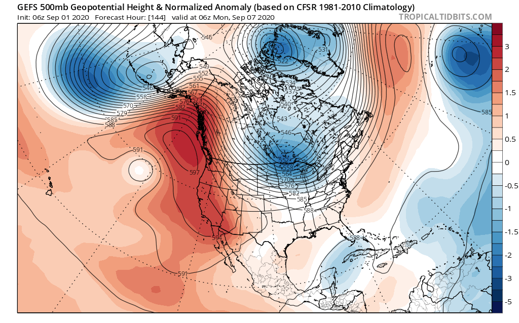
An extremely anomalous ridge of high pressure will strengthen “in situ” over the Pacific Northwest and California over the next few days, likely peaking in strength around Sunday or Monday. As this ridge builds, temperatures will steadily climb beginning today across inland areas and this weekend across coastal areas. Multi-model ensembles are suggesting that the magnitude of this high pressure system over the northeastern Pacific, Pacific Northwest, and California will likely be at record levels for the time of year.
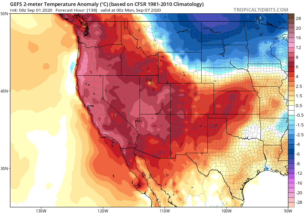
By Sunday and Monday, widespread daily record high temperatures are likely except perhaps at the immediate coast in NorCal–and even there, there is some potential for coastal temps to rise more than currently expected. Portions of the Central Valley could approach or even exceed 110 degrees during this heat event. Here, as well across portions of SoCal, some locations stand a good chance of breaking all-time monthly temperature records for September during this event.
Extremely warm early autumn temperatures will extend essentially from the U.S./Mexico border all the way northward into portions of British Columbia; record high temperatures and very dry conditions may result in significant wildfire activity expanding northward into Oregon.

Some silver linings: this heatwave will probably be a bit more tolerable than during the last event given lateness of season, lower sun angle, and better overnight temperature recoveries. This will also be a “dry heat,” unlike the unbearably humid one we experienced in mid-August.
And then there is the matter of the extensive smoke cover that already exists across most of northern California, and is expected to persist to some degree for the foreseeable future. On the one hand, areas with thick smoke cover may see slightly reduced temperatures relative to what would have otherwise occurred–which may even prevent some cities from hitting new September temperature records. On the other hand, smoke may make it impossible to seek relief from the heat by spending time outside or even opening windows–which could amplify the already substantial health effects. All in all, I don’t think this is a heatwave that most folks in California are particularly looking forward to at this point.

Mid-September prospects uncertain, but fire weather risks loom large
Right now, there is quite a bit of uncertainty regarding how the large-scale pattern might evolve in the 10-15 day period. Right now, the ECMWF ensemble suggests that a strong West Coast ridge will continue to dominate for the next 2-3 weeks–bringing largely warmer and drier than average conditions to most of the West Coast (including all of California). This, obviously, would keep fire weather conditions substantially elevated (though perhaps not extremely so, in the absence of any major wind events).

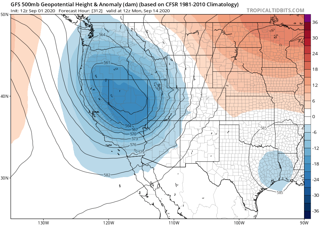
The GFS ensemble has recently started to disagree–and now suggests the potential for a potent early-season “inside slider”-type low pressure system to drop southward over Nevada and interior California in the 7-10 day period. If this were to happen, I would expect a fairly dramatic cooling trend (which would be good news), but also a potentially significant offshore/north wind event (which would be very problematic) along with continued dry conditions. At this point in time, neither of these scenarios would be great from a fire weather perspective, especially given that there are still numerous large fires burning across NorCal that will likely still be burning 10-15 days from now. I really do wish I had better news to pass along about the weather to come, but the reality is that autumn is often peak fire season in coastal California due to the increasing prevalence of offshore wind events. Most of the state probably has at least 2 months of fire season remaining, perhaps 3 (or even 4 in SoCal). My hope is that we can at least avoid a large number of additional fire ignitions in the coming weeks and months given the extremely dry state of the vegetation and the ongoing fire crisis, but given the realities of modern California that’s more wishful thinking than anything else. Stay safe out there.
Discover more from Weather West
Subscribe to get the latest posts sent to your email.