A record dry February for California
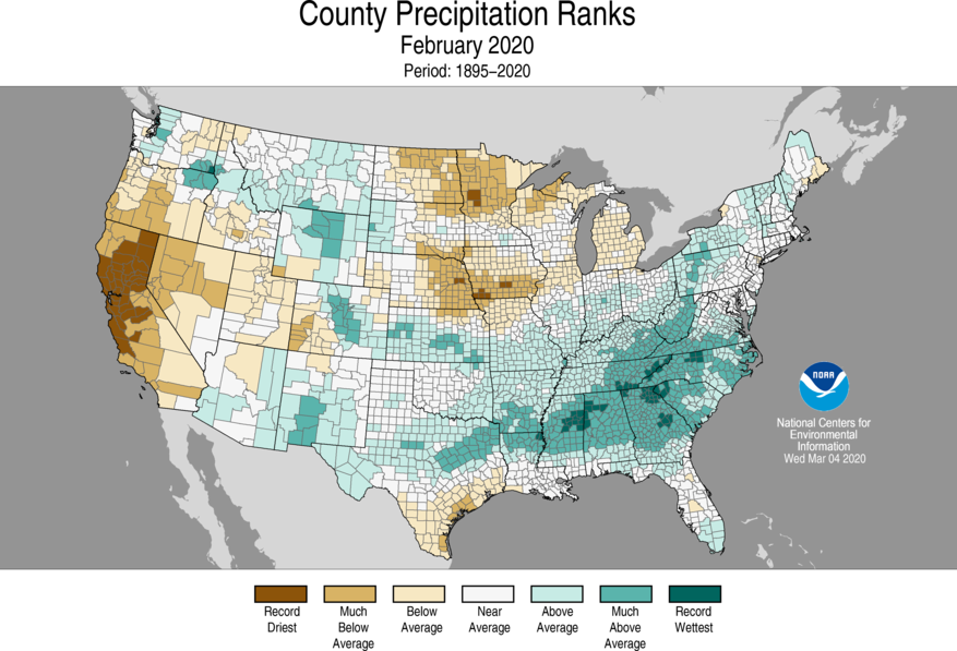
Most of California experienced its driest February on record in 2020–on the heels of what had already been a very dry start to winter (and autumn before it, at least in Northern California). Many places saw zero precipitation of any kind for the first time in over 100 years of precipitation records–quite a remarkable feat during what is typically one of the wettest months of the year in this part of the world. Temperatures during February were also well above average, with record spring or even summer-like warmth occurring on quite a few days. Sierra Nevada snowpack, already suffering after a dry January, dropped rapidly amid dry and warm conditions. As of today, state-wide snowpack is around 38% of average for the date.
The first half of March has been a bit different–at least in Southern California. While Northern California has remained much drier than average over the past couple of weeks, a series of slow-moving cut-off low pressure systems have brought widespread rainfall to the southern third of the state. Some of this precipitation has been quite substantial, with some local flooding issues popping up (especially in the deserts). There has even been some fairly widespread thunderstorm activity down south in recent days–making for a decidedly more interesting weather pattern than has been seen as of late. NorCal, though, has largely been bypassed by the precipitation so far in March.
Yes, finally: widespread NorCal rain and heavy mountain snow
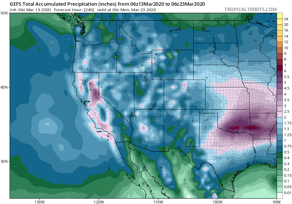
At a time when I think most folks could use a bit of good news, I’m glad to have some to report: the entire state of California’s going to get a good soaking over the coming week, and the Sierra Nevada’s going to get a huge amount of snow.
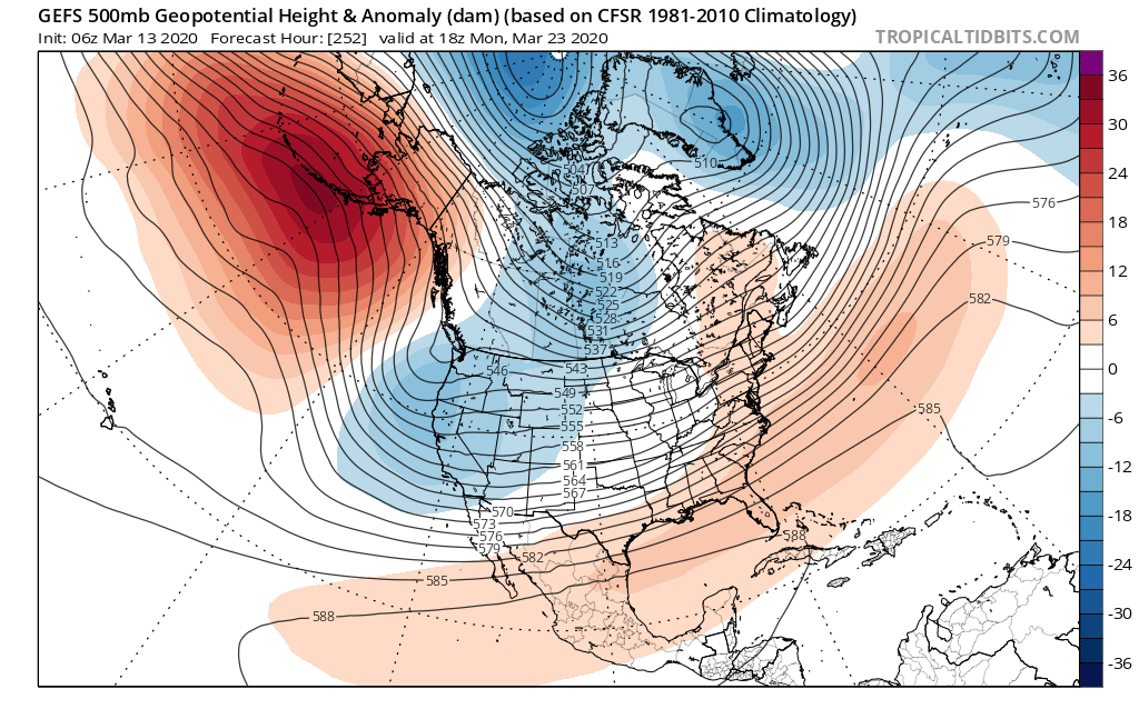
What has changed? Well, interestingly, the large-scale pattern over the North Pacific actually hasn’t changed much–there’s still a highly persistent ridge of anomalous high pressure centered south and southwest of Alaska. But a subtle westward shift (retrogression) in this mean ridge axis is allowing cold storms to dive southward slightly west of the overland trajectory they have had for much of the winter so far. The net result: with even a nominally overwater trajectory, these cold systems will finally start producing widespread cold precipitation instead of just dry offshore wind events, since they’ll be able to pick up some moisture from the Pacific Ocean.
Interestingly, these still appear to be relatively moisture-starved systems–but they will still pack a substantial punch for two key reasons. First, they will be rather cold for this time of year–and such cold air aloft in the mid-levels will favor widespread convective activity (showers and isolated thunderstorms) and prodigious snowfall along the Sierra Nevada crest and western slopes. Second, they will be slow moving, as the longwave pattern remains quasi-stationary and repeated waves of reinforcing cold air continue to dive down from the north.
These will still not be huge precipitation producers in coastal areas; overall precipitation totals may remain on moderate side there, though with occasional heavy downpours as convective activity picks up. But due to a combination of favorable orographic and slow movement, the western slopes of the central and northern Sierra Nevada may be the real winners. Here, liquid equivalent precipitation on the order of 4-5 inches is likely. Along the crest, this could translate to 3-4 feet (or locally even more) of snow over a 3-4 day period! But even the Tahoe area and lower elevation spots as low as 2,500 feet should see substantial snowfall from this event. In fact, this will likely be the largest snowstorm of the entire season for much of the region–which will make for a decidedly strange seasonal cycle in 2020.
Occasional thunderstorm activity is likely over the next 7-10 days across California, as is typical with cold storms this late in the season. I would not be surprised to see reports of accumulating small hail in some spots, as well as a few severe storms in the typical spots (i.e., portions of the Central Valley). A bit of accumulating snowfall may even be possible in some of the coastal hills down to around 2,500 feet–especially during heavy convective precipitation.
“March Mitigation” to continue through end of month
Right now, it appears that an unsettled pattern similar to the one described above will persist for the rest of March, given the projected position of the upstream blocking high pressure system southwest of Alaska. As a result, I would expect some modest recovery of seasonal precipitation deficits in many spots, although NorCal will still remain well behind seasonal norms both in terms of total precipitation and accumulated snowpack. Therefore, unless the forecast shifts toward much moister systems heading into April, I would seriously hesitate to call this a “Miracle March.” Still, the widespread precipitation and cool weather expected statewide over the next 10+ days is decidedly good news–and I think it’s be fair to call it a “March Mitigation,” at least.
Staying informed during the COVID19 pandemic
Many folks are, quite understandably, experiencing anxiety and concern surrounding the emerging global pandemic, caused by the rapid global spread of a novel coronavirus (SARS-CoV-2) and leading to a sometimes severe illness known as COVID19. There is presently quite a bit of misinformation surrounding this global public health emergency, and traditional media outlets have often been running “behind the curve.” To be clear: I have no professional expertise whatsoever in public health or virology. But as a scientist-communicator, a big part of my job is seeking out reliable sources of information. And so, for both my own edification and for the sake of improved science communication during a rapidly-evolving crisis, I’ve created a formal list of excellent and highly-qualified public health experts and virologists who are using Twitter as a platform to speak directly to the public. Please feel free to use and share this public list below (no Twitter account needed to access). Stay healthy out there, and please do wash your hands.
Discover more from Weather West
Subscribe to get the latest posts sent to your email.