Finally looks like the wet season in California
Following what turned out to be an exceptionally dry autumn in California, especially in the north, winter-like weather arrived in fairly dramatic fashion around Thanksgiving–and the active pattern has continued since. An unusually cold storm last week dropped significant snow at unusually low elevations for this early in the season–bringing widespread travel headaches but also widespread relief from fire season. Nearly all of California has now seen significant precipitation this season, nearly all of which has fallen in the past 1-2 weeks. And more is on the way, at least in the short term.
Classic winter storm on California’s doorstep this afternoon

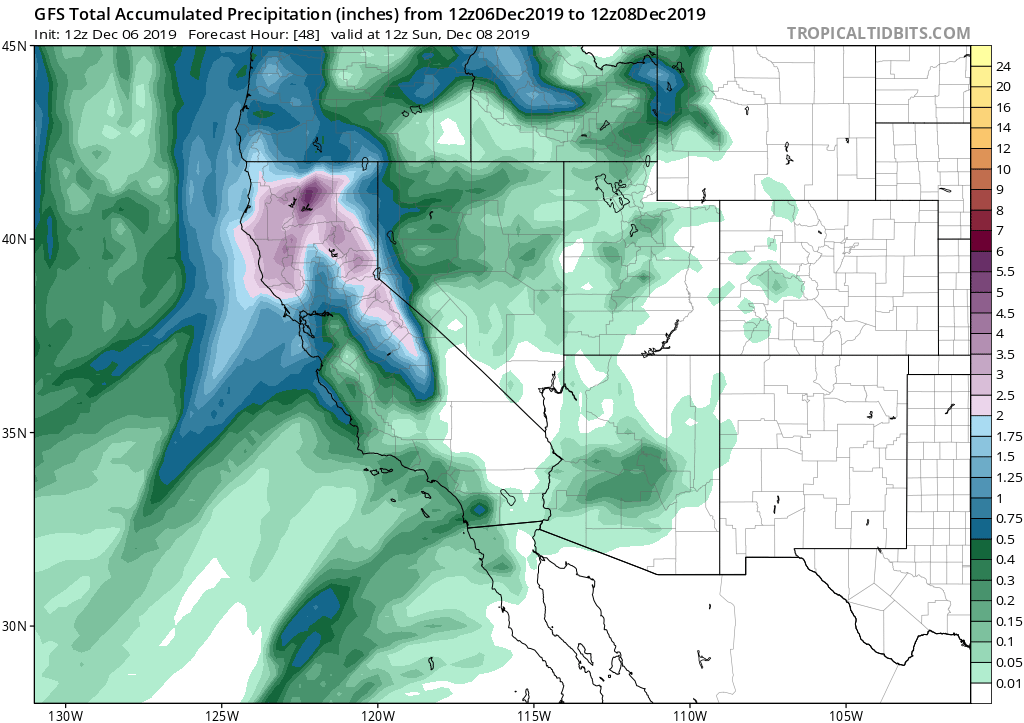
There’s yet more truly spectacular satellite imagery today as a cold and unstable storm approaches California from the northwest this afternoon. (I wrote this blog post partly to have an excuse to showcase this imagery.) A strong cold front is rapidly approaching the NorCal coast this PM, and will bring widespread rain (mountain snow) and gusty winds this evening to most places north of Monterey. Rain totals will not be especially extreme, with an inch or two expected in the favored spots and less than that elsewhere in NorCal. SoCal is currently seeing some light to moderate rainfall and will see a bit more as this cold front washes out along the South Coast tonight into tomorrow, although generally this does not appear to be a significant storm event for Southern California.
Strong thunderstorms possible Saturday in NorCal

One of most impressive aspects of the satellite imagery above is the notably “bubbly” (i.e., convective) nature of the cloudiness associated with the incoming storm–both along the leading cold front and especially in the cyclonic cold pool in the airmass behind the front. As this relatively cold and very unstable (by California standards) airmass moves inland across Northern California tomorrow, many areas may actually see larger rainfall accumulations and higher rainfall rates than during the cold frontal passage today! In fact, all of the NWS offices in NorCal have issued Flash Flood Watches for the recent wildfire burn scars from Sonoma County northward to the Oregon border (there are…quite a few such scars).
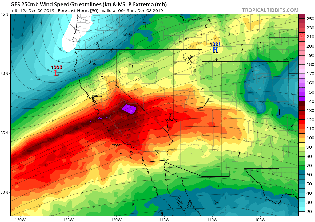
Why does tomorrow look so interesting, convectively speaking, in NorCal? Well, the cyclonic cold pool appears likely to move onshore during the morning hours and be centered directly over the Central Valley during the afternoon hours, when peak surface heating may occur through breaks in the clouds. As a cyclonically-curved jet streak briefly flares up over Central California, much of interior NorCal will be in a region favorable for the development of thunderstorms (i.e., the “left exit region” of the jet, which favors general upward motion and cloud development). Coupled with upper-level cold advection and surface heating due to sunny breaks in the morning cloud layer, these factors could easily lead to the development of strong (or even isolated severe) thunderstorms–particularly along the eastern and northern fringes of the Sacramento Valley. At a minimum, I’d expect numerous showers/scattered thunderstorms containing copious small hail–and it possible there will be few supercells with larger hail or even an isolated tornado (as does happen in this part of the state more often than many folks realize). Other parts of NorCal will likely see occasional heavy downpours and possible thunderstorms–they just won’t be as strong as in the Central Valley.
It’s worth noting that these post-frontal convective bands will bring the greatest risk of flash flooding to recent NorCal burn scars, and if a training line of cells sets up somewhere inopportune, significant (but localized) flooding could result. Tomorrow will definitely be a day to keep an eye to the sky if you live near a recent NorCal burn scar (and might also make for a photogenic thunderstorm chasing day in the Sacramento Valley, if you’re so inclined).
General warming and drying trend to follow
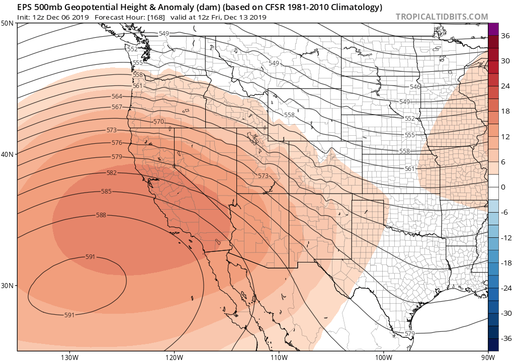
After this weekend’s storm, a relatively modest ridge of high pressure will build over California–shunting the storm track to the north of the state. Significantly warmer and drier conditions will result, probably persisting for a week or more (not necessarily a bad thing at the moment, since the preceding 2 weeks will have been quite wet). Right now, I’m not seeing any obvious signs of a return to a colder or wetter pattern in the week 2 period (despite a couple of opportunities for very light precip in NorCal). I’ll have more to say about that come mid-December!

Discover more from Weather West
Subscribe to get the latest posts sent to your email.