Sudden shift from record heat to localized downpours in SoCal
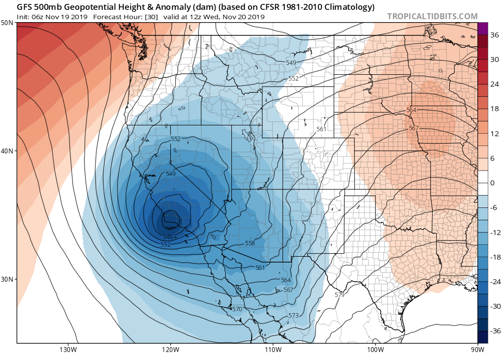
A fairly dramatic weather pattern change will take place today across Southern California. Following several days of record heat nearly statewide (including temperatures that approached all-time November records in some mountain areas), a much cooler airmass has already arrived in California today. This airmass is associated with a cold low pressure system that is currently sliding down the California coast. In addition to bringing much cooler air, this low pressure system is acting to destabilize the atmosphere–especially across southern California. In addition to this destabilization, the low is beginning to entrain some subtropical moisture which is (in turn) currently circulating around a separate, weaker low off the coast of Baja California.
Collectively, the combination of cold temperatures aloft and increasingly abundant moisture in lower levels of the atmosphere will start to produce scattered showers across far southern California (generally south of Los Angeles County) later this afternoon. Then, as the low moves directly over the SoCal Bight tomorrow, more widespread convective activity (including the potential for fairly widespread showers and scattered thunderstorms) will likely develop. Precipitation from this system will be almost exclusively confined to southern California, and even there there is likely to be a strong precipitation gradient (ranging from just isolated to scattered showers near Santa Barbara, possible scattered showers and thunderstorms near Los Angeles, and widespread rain/thunderstorms near San Diego). In fact, some localized flood concerns may even arise near San Diego and across the mountains/deserts just to the east tomorrow afternoon (where a Flash Flood Watch is in effect). In addition, given the magnitude of the cold air aloft, I would not be especially surprised to see a few isolated stronger thunderstorms (perhaps containing some hail) somewhere in SoCal on Wednesday.
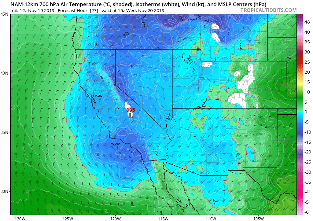
Widespread heavy precipitation is also possible across much of the Desert Southwest, including the SE California deserts and Arizona, as a result of this system and its subtropical moisture tap.
NorCal stays (mostly) dry, with strong north winds leading to increased fire weather threat
Meanwhile, the northern 2/3 of California will likely stay dry during this event–with a couple of exceptions. First, some snowfall is likely on the *eastern* slopes of the Sierra Nevada and along the crest, a product of northeasterly winds rainshadowing the western slopes (a somewhat unusual set-up). Second, a few of the high-resolution regional models are suggesting the possibility of an isolated shower just about anywhere in Northern California tomorrow, so there is (perhaps) a 10-20% chance of very brief precipitation. Otherwise, however, broad swaths of NorCal will likely stay completely dry for the next 7-9 days.
Unfortunately, this cold low pressure system will also generate relatively strong and gusty winds across NorCal later today into tomorrow. These winds will be associated with falling relative humidity, and will combine to create locally critical fire weather conditions. Neither the winds nor the humidity in this case will be particularly exceptional by themselves–but what is exceptional is the continuing summer-like dryness of vegetation in NorCal. In fact, fuels continue to be at or below record dry levels for the time of year across nearly all of Northern California. Record heat over the past couple of days has not helped the situation, but in general this autumn has actually not been an especially warm one across NorCal.
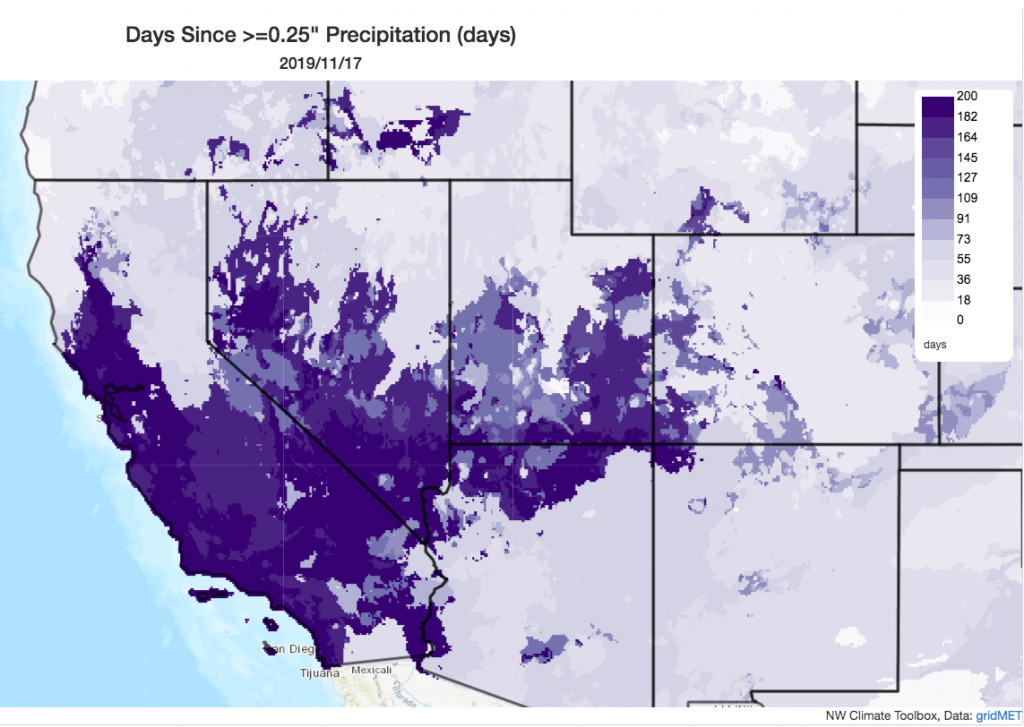
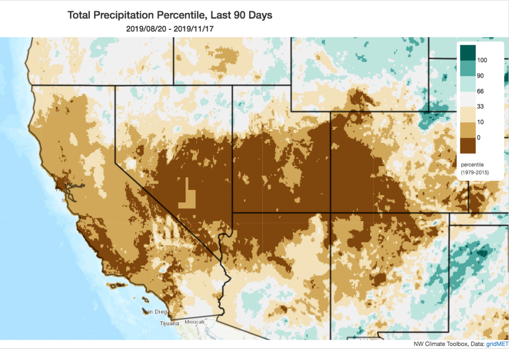
Instead, the extraordinarily late onset to the rainy season, combined with some extremely low humidity during October/November offshore flow events, has resulted in vegetation desiccated to summer-like levels. It has been over 185 days since the last soaking (>0.25 inch) rainfall event across broad swaths of the state–a statistic that is only mildly unusual in SoCal, but is quite exceptional north of the Bay Area. In fact, coastal parts of the state are currently tracking near or at record dry levels for the autumn to date. While a true “November shut-out” is looking less likely (see following section), given continued dry conditions over the next 7-9 days it’s certainly possible that some locations in NorCal will end up reporting their driest autumn (Sep-Nov) period of record when all is said and done.
Due to the elevated and unseasonable fire weather concerns tomorrow, the NWS has issued Red Flag Warnings across a broad portion of NorCal. Additionally, PG&E has announced another fairly widespread Public Safety Power Shut-off, which is currently anticipated to affect around 750,000 people (while large, that’s less than a third as large as earlier shut-offs this autumn, which affected around 3 million people).
Mixed signals for relief through early Dec
The bad news: there’s still no clear sign that the Pacific jet will shift into a more typical configuration for late autumn/early winter–meaning that below-average precipitation is highly likely to continue through the end of November and perhaps early December. The good news: it’s looking increasingly likely that at least *some* precipitation will finally fall across NorCal around Thanksgiving.
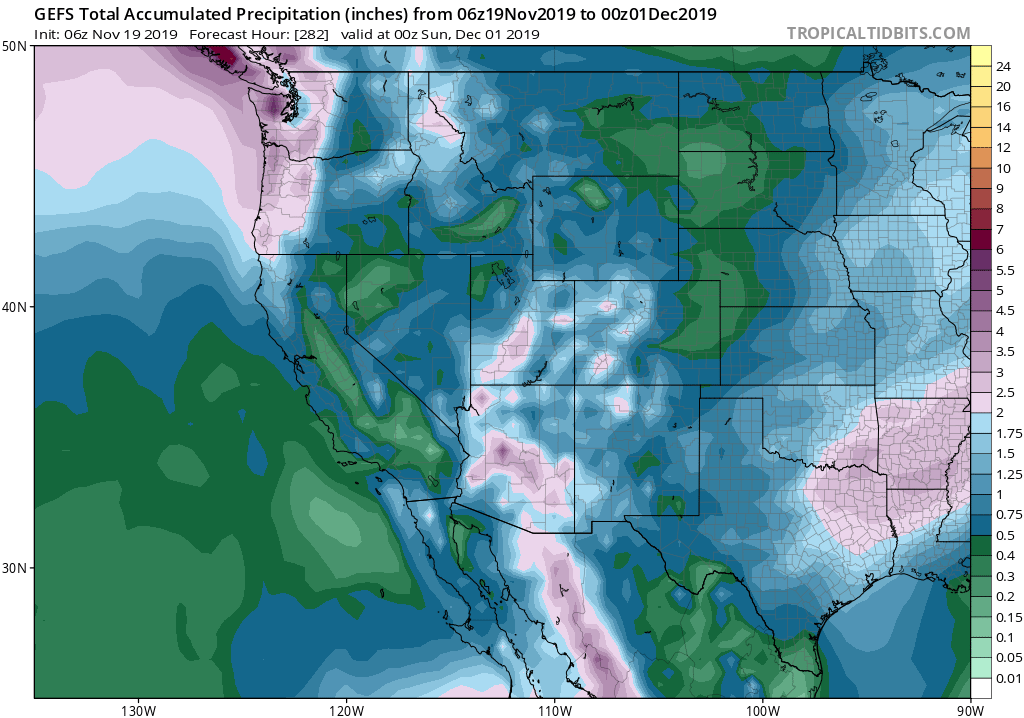
First, there’s a slight chance that a weak secondary low pressure system will briefly pop up off the central coast, perhaps bringing a chance of showers late this week to the immediate coastline south of the Bay Area (although this is not especially likely). After that, things calm down until the middle of next week–when another cold system appears likely to affect the state. The tricky part: models have recently suggested this system could take an “inside slider” trajectory, which would bring only a chance of showers to the mountains and the potential for an even stronger north wind event than is expected tomorrow. In fact, the potential for yet another substantial and widespread fire weather event in NorCal–including the potential for another round of PSPS–exists for the early-middle portion of next week.
Thereafter, however, it does appear that some relatively weak systems will have an increasingly good chance of making progress into NorCal, hopefully bringing at least some light rain and mountain snow that will help to shut down fire season. This is still a bit tenuous, since multi-model ensembles are *not* suggesting widespread heavy precipitation, and we’ve seen the can kicked down the road several times already this autumn. But for now, I’m cautiously optimistic that we might finally see some fire season-attenuating rainfall in NorCal around Thanksgiving, or shortly thereafter. (And hopefully tomorrow’s precipitation will have that effect across portions of SoCal.) Fingers crossed!
Discover more from Weather West
Subscribe to get the latest posts sent to your email.