An exceptionally hot summer so far
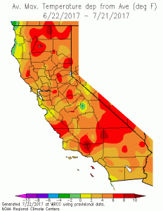
Despite a mild spring across most of California, summer 2017 has been truly searing across most of California away from the immediate coastline. Numerous, prolonged heatwaves have brought an extended period of well above-average temperatures at the height of summer, with temperature falling to around average for only brief periods. There has been an exception to the unrelenting heat in California’s interior: regions within 5-10 miles of the Pacific ocean have experienced greatly muted effects from these heatwaves, as they (so far) have not coincided with periods of strong offshore flow. Still, ocean surface temperatures have started to rise in response to persistent heat and weak coastal upwelling–and even the beaches have started to experience anomalously warm temperatures in recent days. This is especially true in Southern California, where SSTs into the 70s in some spots have greatly curtailed the typical seabreeze circulation, raised surface humidity into uncomfortable territory, and have prevented overnight temperatures from falling much below 70 degrees.
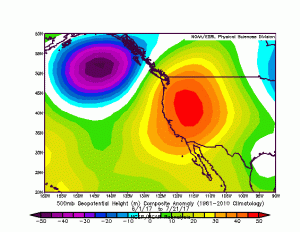
What’s causing this extreme inland heat and unusual/uncomfortable SoCal humidity? An unusually persistent ridge has developed somewhat to the west of its typical summertime position over the Desert Southwest, which has favored the occurrence of numerous heatwaves across the CA interior. It has been an exceptionally hot summer so far across the entire American West–not just California–though in recent days a robust monsoonal moisture surge has moderated temperatures across Arizona and Nevada. This ridge is not located quite far enough west to bring very hot coastal temperatures, although it has acted to inhibit the northwesterly winds that normally induce cold water upwelling along the coast and has thereby caused coastal SSTs to rise and overnight coastal temperatures to creep upward.
Increasing monsoonal influence; rising heat
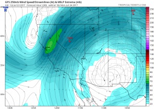
Unfortunately, it appears that this pattern over the next 10+ days will bring more of the same–more heat, and rising humidity–though there will be the potential for some interesting weather at times. As of this writing, an upper-level low pressure center was located off the coast of Northern California, and is expected to move slowly inland through Monday. As it does so, sufficient moisture and elevated instability exists over much of the NorCal interior for potentially widespread thunderstorms later Sunday and Monday across the higher terrain. While much less likely, some isolated storms could occur over the Central Valley or North Coast region given the presence of a somewhat moist airmass. The potential for widespread lightning–even if much of it occurs with wetting rains–is a significant fire weather concern, given the existence of numerous large wildfires already throughout California and the lack of firefighting resources available to address new fires.
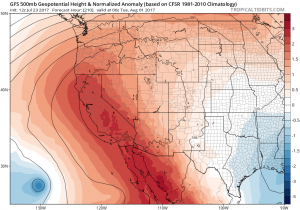
Early this week, a stronger push of monsoonal moisture will also move into Southern California. Mountain and desert thunderstorms are a good bet, and there is also a slight chance of storms all the way to the coast. There is still pretty dramatic inter-model disagreement regarding the westward extent of this moisture in SoCal on Monday and Tuesday, which could mean the difference between unremarkable conditions and a pretty active weather period. At this point, it’s not clear which scenario will win–though it’s worth noting that the global models have done an especially poor job simulating westward monsoonal moisture incursions so far this summer. While such events are always difficult to simulate given California’s position at the far western margin of the monsoon region and the highly stabilizing effect of a relatively cold nearby ocean, it seems that the extreme persistence of anomalous West Coast ridging mentioned earlier has inhibited what otherwise might have been more impressive events so far this year.
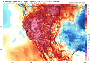
Regardless of the degree of monsoonal moisture that overspreads California, however, there seems to be agreement that the ridge will re-strengthen over California–and that well above-average temperatures will return later this week after a brief lull.
Eastern Pacific extremely active; a tropical “slingshot” possible
Later this week and into next weekend, all eyes turn toward the eastern tropical Pacific Ocean. This region has recently been producing an exceptional number of tropical cyclones (i.e. tropical storms and hurricanes), and activity is actually expected to further increase in the coming days. Unlike recent storms, which have headed almost due westward into the remote Pacific, additional tropical development over the next 7-10 days is expected to take a more northwesterly track. This will potentially put several decaying hurricanes/tropical storms in a position that has historically been favorable for the advection of moisture into California from the south/southwest.
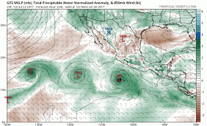
Intriguingly, the GFS has been consistently suggesting the potential for a very unusual interaction to occur between two of these East Pacific tropical cyclones later this week. The animation below shows what is known as a “Fujiwhara interaction” between two such storms west of Baja California, in which two tropical cyclones move close enough to one another to influence each other’s circulation and begin to rotate around a common center. As this occurs, storm motion can become highly nonlinear and very hard to predict, and occasionally results in the smaller storm being “ejected” from the broader gyre in “slingshot” fashion. For what it’s worth, I can’t personally recall a model forecast calling for such an event to occur so close to California (it’s more common in the West Pacific, where typhoons are quite common).
What does this mean for California? At this point, it’s hard to say–tropical influences in California weather are always hard to project more than a few days in advance, and this is doubly true with the potential for such an unusual multi-storm interaction as discussed above. But it does appear there is a pretty good chance that tropical moisture (perhaps complimented by enhanced monsoonal moisture under stronger southeasterly flow) will eventually make it to California in the 5-10 day period. The most direct consequence of this will be a potentially dramatic increase in humidity–which may make the upcoming heat even more miserable. This moisture, however, will also make mountain/desert thunderstorms likely, and may bring a risk of showers/thunderstorms even to coastal areas. There are presently no indications that a tropical rainfall event as substantial as that associated with the remnants of Hurricane Dolores in 2015 is in store–but the situation certainly does bear watching. All in all, it appears that the next couple of weeks have the potential to become pretty interesting by California summer standards.
Discover more from Weather West
Subscribe to get the latest posts sent to your email.