Quiet late spring conditions prevail; snowmelt and subtle warmth continues

Weather-wise, conditions across most of California have been rather quiescent in recent weeks. Despite a record-wet Water Year to date across much of Northern California, it has been a dry (and warm) spring across Southern California. Some early season warmth (in some spots, marginally record-breaking) has allowed for an acceleration in Sierra Nevada snowmelt, and many snow-fed rivers in California and Nevada are currently running high and cold. So far, though, only minor flooding has resulted from snowpack melting in recent days. This is partly because a lot of the snow on the ground has already melted at lower elevations, despite a hefty upper-elevation snowpack–in fact, relatively warm temperatures led to lower elevation snowmelt even during the middle of winter earlier this year.
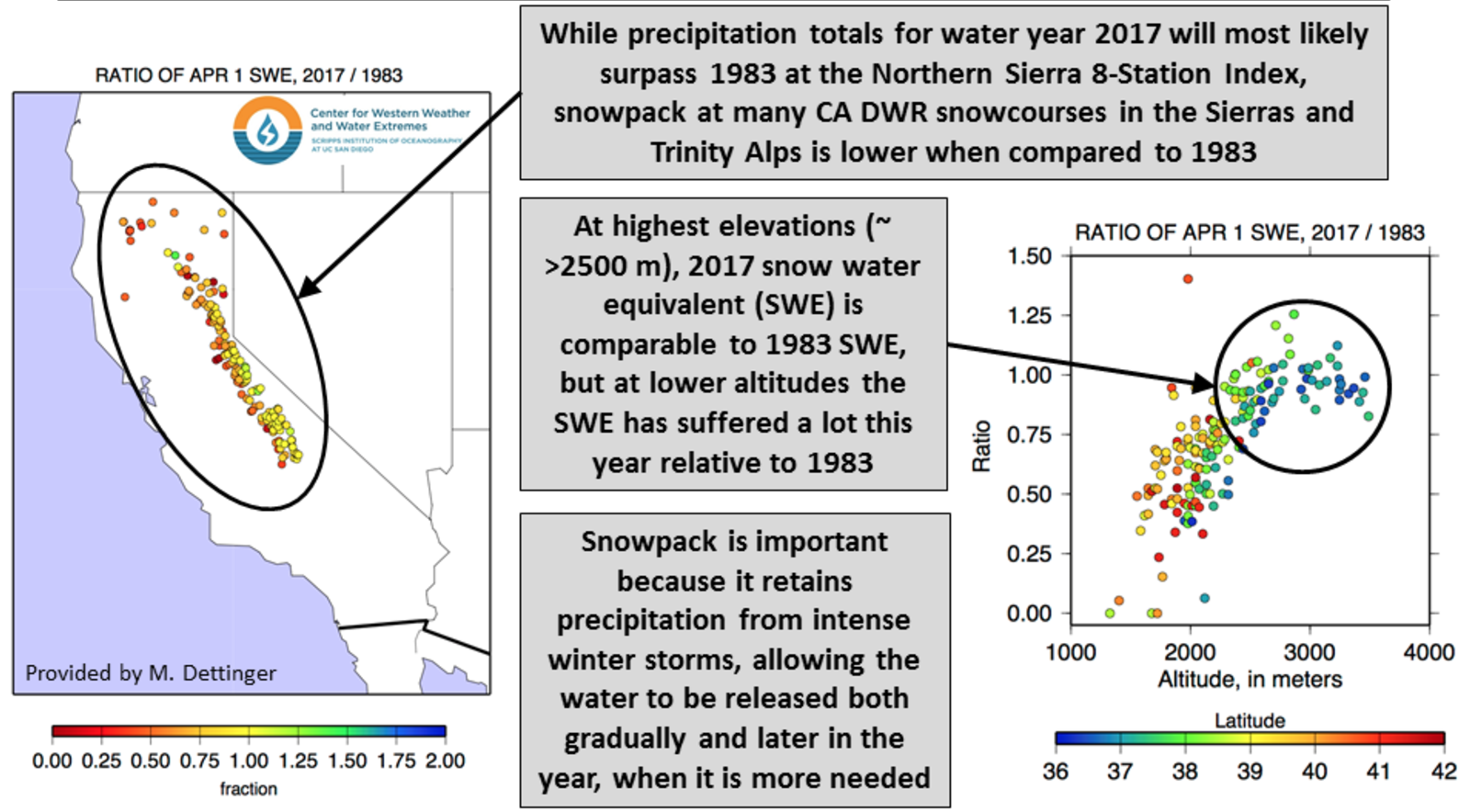
The rather striking graphic above demonstrates just how strong this elevational snowpack gradient has been in 2017–with near-record snow water equivalent comparable to 1983 at the highest elevations and dramatically less accumulation further down the slopes. While not as visually dramatic as the near-total lack of snow in 2015, 2017 featured at least the fifth consecutive winter where a below-average fraction of precipitation fell as snow (as opposed to rain). A flurry of recent research strongly suggests that recent observations like these are indeed linked to California’s long-term warming trend–and that snowpack losses are expected to accelerate further over the next few decades.
Typical early-summer conditions likely to persist across California
At the moment, there is multi-model ensemble agreement that relatively quiet conditions are likely to continue across California for the next couple of weeks. This is not too surprising, as late May/early June is historically one of the most stable periods of the year across most of the state, as the winter rainy season has fully tapered off and the peak of the summer heat wave and “monsoonal surge” season has yet to begin. There is, however, a fair bit of agreement that conditions will continue to be at least somewhat warmer than average across most of the state, especially in the north (and with the exception of coastal Southern California, where persistent a “June Gloom” marine layer will keep things cool). No big heatwaves are currently on the horizon, but persistent warmth will keep snowmelt going at a fairly rapid pace.
Some thoughts regarding the coming summer and beyond
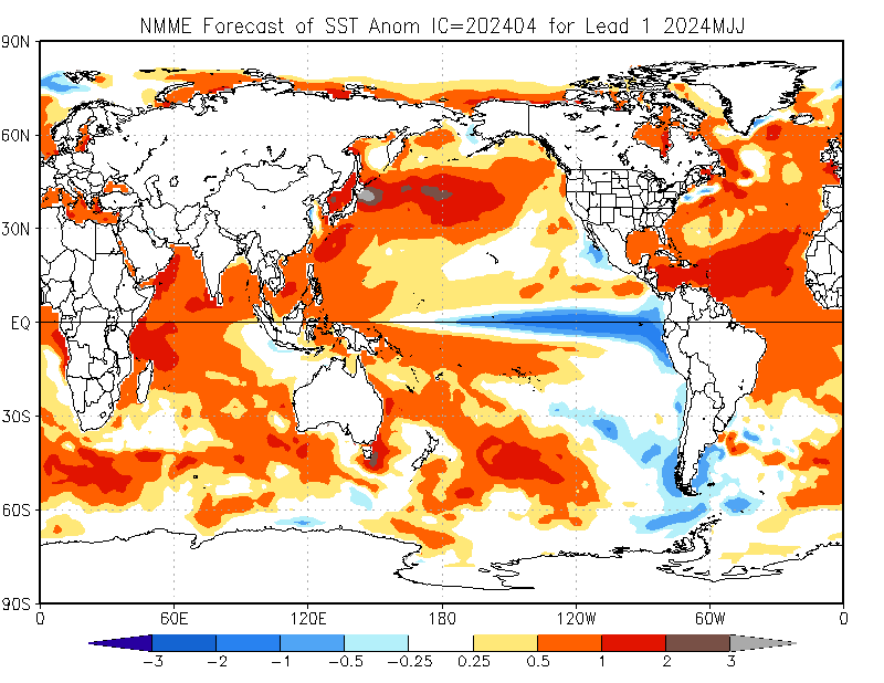
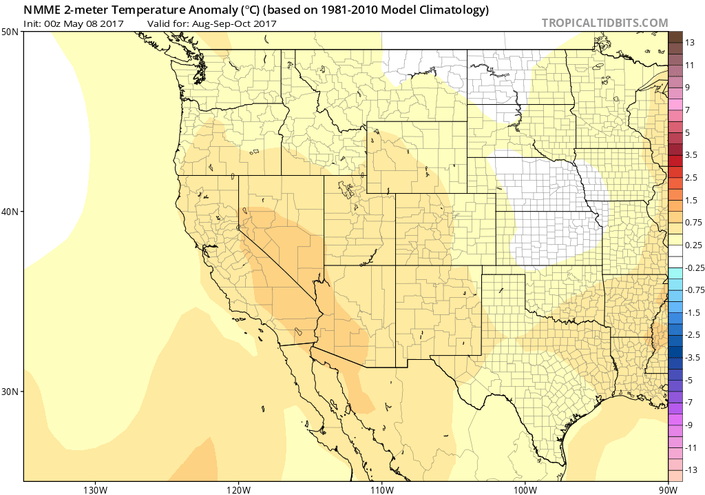
The North American Multi-Model Ensemble (which does, in fact, exhibit pretty good predictive skill for summer temperatures in the American West) is presently suggesting a high likelihood of a warmer-than-average summer in California (and, indeed, most of the Northern Hemisphere). Much of this is likely a product of temperatures in the subtropical Pacific Ocean, which remain warmer than average for this time of year. While this doesn’t necessarily portend more extreme heatwaves than usual, the multi-model mean also suggest that anomalous warmth will persist over California during the late summer and early autumn–a time when coastal heatwaves are far more likely. So while a hearty marine layer may keep things comfortably cool in the coming weeks, more substantial heat may be on tap later in the summer.
And what’s going on in the tropical Pacific Ocean? Well, as we start to emerge from the Spring Predictability Barrier, the coupled ocean-atmosphere have indeed changed their tune. While most models were calling fairly aggressively for a significant “traditional’ (i.e. east-centered) El Niño event by late summer and autumn, they’re now hinting at warm event centered in the Central Pacific (closer to an El Niño Modoki). It’s still too early to say with any confidence how things are going to evolve this summer, but it’s worth noting that from a California perspective it matters a great deal where the region of maximum tropical warming is located. I’ll continue to revisit developments in the tropical Pacific through the summer.
And finally, a minor announcement regarding the Weather West site itself. Historically, the substantial and growing costs associated with maintaining and operating Weather West have been covered by the inclusion of web-based advertisements on the site. In response to reader feedback and in attempt to improve site experience via reduced ad coverage, I’m experimenting with a voluntary crowdsourced contribution model. To be clear: all Weather West content will continue to remain freely available to everyone, but if you’re interested in helping to subsidize a better experience for all readers, please check out the Weather West Patreon page. Thanks!
Discover more from Weather West
Subscribe to get the latest posts sent to your email.