Following a ridiculous ridge in March and associated record-shattering warmth, a more transient pattern has established in April
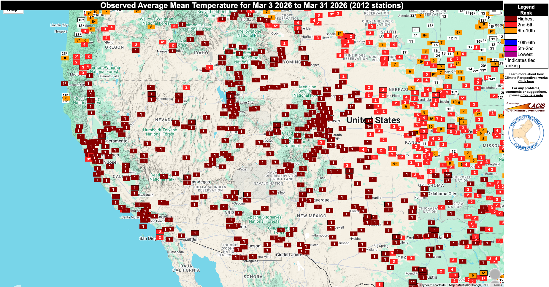
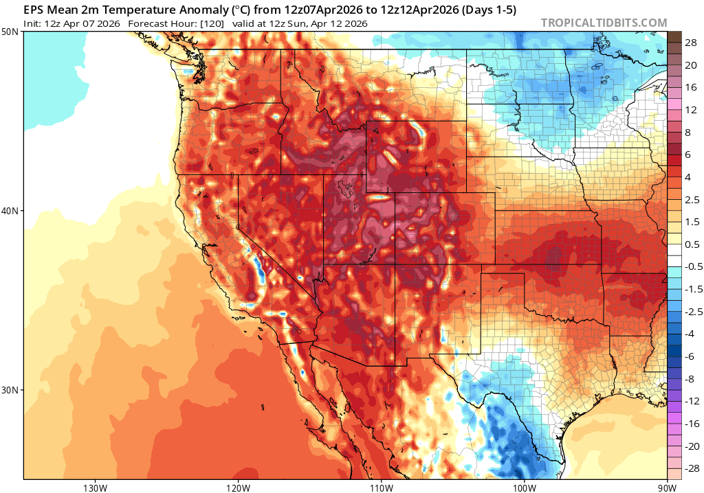
Well, I won’t belabor the point: March 2026 was a month that will long be remembered for its astonishing warmth across California and the broader West. Snowpack in most regions is now near or below all-time record lows for early April as a result, despite a very modest recent boost. And temperatures have once again rebounded to somewhere between “much warmer than average” and “record breaking” in recent days (though, it is worth noting, far from “record shattering” this time earound), so April has generally been off to a very warm start once again.
But April is not shaping up to be like March in the West, fortunately, despite the warm start. As the sections below describe, April is shaping up to be a much more active month, storm activity wise, and temperatures will alternate between warm and cool as opposed to being stuck seemingly at the very top of the thermometer for weeks on end.
An unusual warm-sector thunderstorm threat Wed-Fri across NorCal, with a few severe storms possible
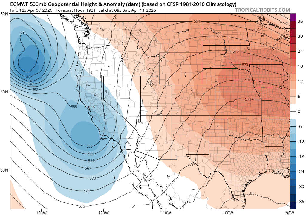
I am sitting here late on Tuesday evening trying to get this blog post out before tomorrow, because the next 3 days will likely feature some very interesting and unusual weather across much of NorCal. By Wednesday afternoon, a slow-moving cut-off low pressure system will drift toward the coastline. This system will be associated with a modest subtropical moisture tap, but perhaps more notably it will drift into what is already an exceptionally warm airmass. The combination of very warm and moist near-surface air (by California standards), somewhat colder air aloft, and a favorable cyclonically-curved upper-level flow pattern over NorCal will bring an increasing potential for thunderstorm activity each afternoon from Wednesday into Friday. On Wednesday, the highest chance of thunderstorms will be over the northern Sacramento Valley, northern Coast Ranges, and northern Sierra foothills. But on Thursday and especially Friday, the potential for more widespread thunderstorm activity will grow to encompass the entire Central Valley, much of the SF Bay Area, and all NorCal mountains.
In fact, there will probably be at least a couple (and perhaps more than a couple) severe thunderstorms, including an isolated photogenic supercell or two, somewhere over NorCal during this period. The highest odds will be in the Central Valley, especially the northern Sacramento Valley, where warmer/moister air will likely pool, but in such an unusually warm, moist and unstable airmass boundary interactions could lead to stronger storms just about anywhere. CAPE could locally reach or exceed 1,000-1,500 J/kg during this period, which is more than adequate for robust California thunderstorm activity.
The first wave of this system will feel notably “weird” by Northern California April standards: it will be fairly warm and muggy with potentially dramatic cumulonimbus clouds about. That kind of weather is common in spring in many parts of the world, but not usually this one!
Unsettled conditions continue at least through this weekend, with some Sierra snow accumulation likely
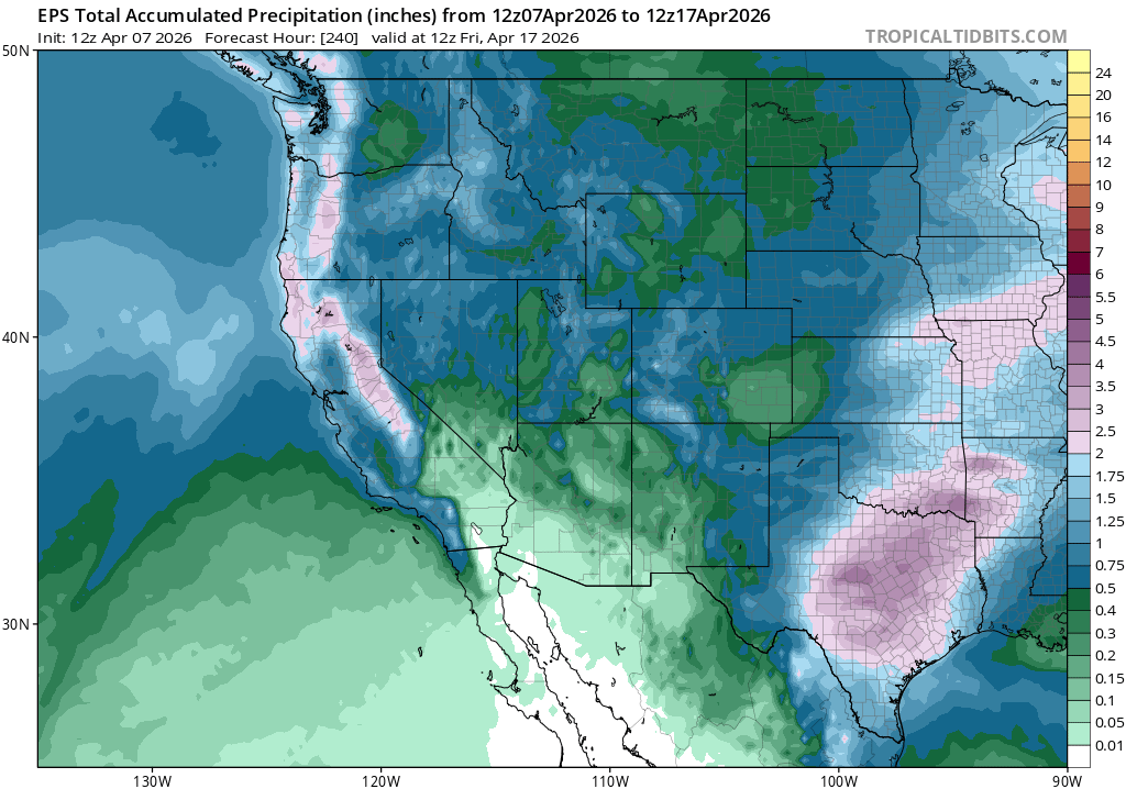
The active weather pattern doesn’t end there. On Saturday, a secondary low pressure system will approach the CA coast. This one will be colder, and will have better dynamical support (but will also have less moisture, and will move through faster). This second system will bring a more consolidated wave of organized showers to coastal/valley regions, and probably at least some isolated thunderstorms once again as a cyclonically curved jet streak generates upper-level divergence in its left front quadrant. This low will likely bring some precipitation to SoCal as well as NorCal. Some briefly heavy downpours and isolated thunderstorms will be possible further south, as well.
The first system will bring all rain, even to the highest Sierra peaks, Wed-Fri. The second system will start out quite warm (7-8k + snow levels), but colder air aloft will quickly filter in and eventually drop snow levels below 6k feet (and perhaps briefly down to 4.5-5k ft). Snow accumulations are likely, mostly at very high elevations but some is certainly possible lower on the back end of this system. So it seems almost inevitable, given that essentially no snow fell last month, that April will be a definitely snowier month than March this year in the Sierra Nevada. But it’s worth noting that this Sierra precipitation will be beneficial whether it falls as rain or snow; given the exceptionally poor snowpack, at this point anything that bolsters late-season soil moisture and runoff will be helpful moving forward.
Wild times ahead in the tropical Pacific portend chaos not just in April, but potentially well beyond
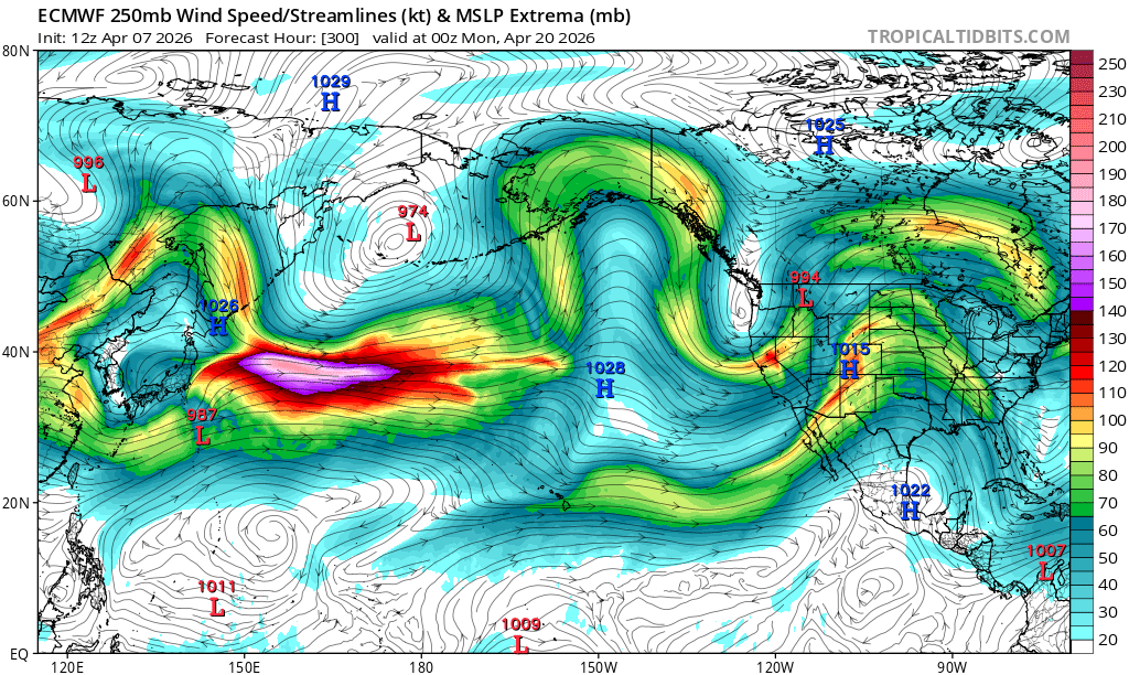
And the drama may not end there! There is major uncertainty regarding what happens beyond this weekend’s secondary and colder low pressure system. The subtropical jet stream over the North Pacific is looking unusually active for spring, and this is likely at least indirectly related to various happenings in the more tropical part of the Pacific Basin. A Very strong westerly wind burst (WWB) is now ongoing, which will likely further increase the likelihood that a major El Niño event develops in the coming weeks and months by reinforcing an eastward-propagating subsurface Kelvin wave. Part of the reason for this current WWB is the development of a rare cross-equatorial trio of tropical cyclones, which is acting as a “slingshot” to accelerate these west-to-east tropical winds. The northern hemisphere typhoon, which is expected to intensity considerably in the coming days, will likely recurve into the mid-latitudes east of Japan in about a week.
As this typhoon recurves, it appears likely this localized injection of energy and moisture in the West Pacific will substantially perturb the Pacific jet–perhaps leading to a pronounced late-season jet extension. When this happens in autumn or spring–as has occurred repeatedly in recent years–it tends to lead to various flavors of “North Pacific drama” by perturbing the overall flow pattern and increasing its amplitude, or “waviness.” This often has two effects: 1) It can generate strong-to-extreme ridge and trough anomalies between Japan and the western U.S., and 2) it can result in a highly volatile weather forecast. The latter follows from the former, as the exact longitude of subsequently amplified ridges and troughs can mean the difference between anomalous heat and dryness vs a rare late season stormy pattern.
Right now, a high degree of uncertainty is apparent in ensemble forecasts, with a very wide range of outcomes ranging from quite warm and dry to notably wet by April standards. At the moment, I have no idea which will win out. So for now: enjoy the cloud watching this week, the rain and even some higher mountain snow this weekend, and let’s check in again next week.
YouTube livestream on April 8th at 2pm PT to discuss inbound thunderstorm potential, broader April pattern, and offer an update on recent federal developments in the weather and climate world
See many of you there!
Discover more from Weather West
Subscribe to get the latest posts sent to your email.