An extremely warm and very moist airmass over California to start the week; record low Sierra snowpack persists
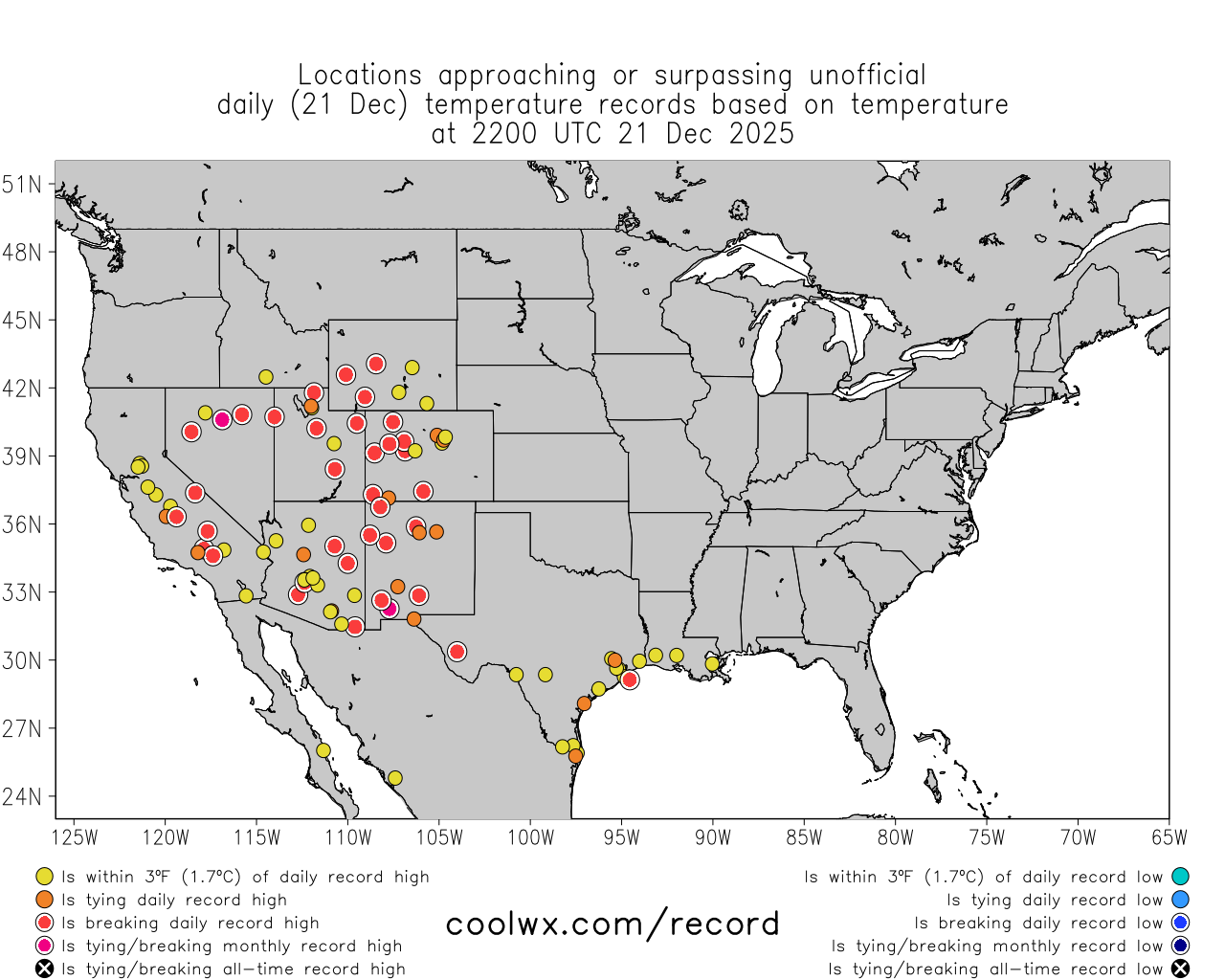
Well, the last 3-4 weeks sure have been exceptionally warm across most of the Western United States. Record warmth has occurred literally every day across a substantial chunk of the western third of the country. Accordingly, December 2025 is likely to end up as the warmest on record across a wide region; snowpack in most basins is at record or near-record lows. Even as I write this blog post, numerous locations are once again experiencing record warmth across the West (including a couple of locations even reaching or exceeding December monthly records). Notably, today this does include portions of California’s Central Valley. This is in stark contrast to the last 3+ weeks, which featured a localized but very persistent region of dense tule fog/stratus and unusually cool temperatures for days on end. Today, however, a few places in the San Joaquin Valley are experiencing daily record *high* temperatures–finally getting a taste of the record warm airmass that has been sitting just a few thousand feet above the surface for weeks.
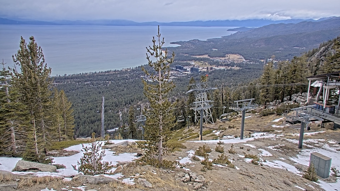
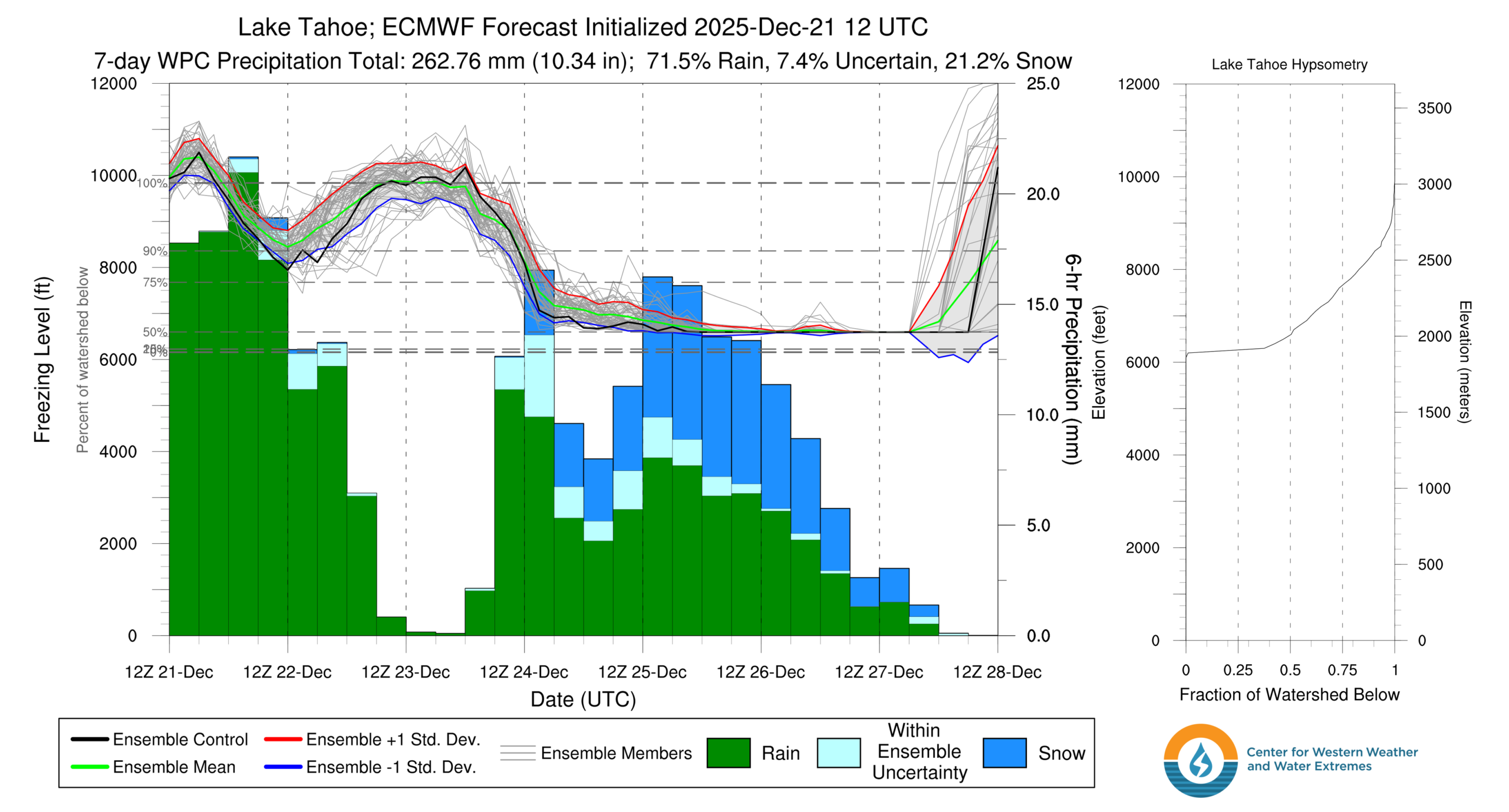
In the Sierra Nevada, particularly in the central and northern part of the mountain chain (which is both somewhat lower in elevation, and thus warmer on average, than the southern portion–and which also did not receive the record-breaking early-season precipitation in Oct-Nov that occurred in the south), snowpack is currently at record low levels for the late December date. At many observing sites below 7,000 feet elevation, this means there is literally zero measurable snow on the ground. At some higher elevation locations, this means there is some very shallow and actively melting snow (mainly on north-facing slopes, and in the shade). This is evidenced by the actual snow course data, but can also be plainly seen (despite the protestations in my inbox this week that things are “totally normal” at Tahoe) by looking at the live web camera views from Sierra ski resorts. I’ve included a striking screenshot from the camera overlooking South Lake Tahoe from the top of the Heavenly tram (which is at ~8,250 feet elevation). I’ll leave it to the reader to determine whether this is a “totally normal” view from 8,250 feet in late December in the Sierra Nevada…
Slow-moving and warm/moist but dynamically weak atmospheric river shifts to more classic winter storm pattern by Wed
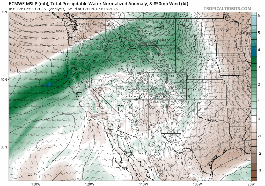
Since Friday, a persistent, very warm, and very moist plume of water vapor transport (also known as an “atmospheric river”) has been largely stalled over Northern California. This atmospheric river has subtropical origins, and its inherent warmth is being further boosted by anomalously warm ocean surface temperatures along and offshore the entire California coast. This atmospheric river is pretty impressive when viewed from a temperature and total column water vapor perspective–it’s an exceptionally warm and moist airmass–but much less so when it comes to its “dynamics.” In other words, there’s a whole lot of moisture and latent energy in this airmass, but there is little ambient upward motion in the atmosphere to “squeeze out” all that moisture as precipitation. This is, therefore, a classic example of a very moist but dynamics-starved atmospheric river than can produce (and has produced) long periods of heavy orographic precipitation in favored mountain areas (since the mountains themselves act as the source of precipitation-inducing uplift), but relatively little precipitation elsewhere (near sea level and in rain-shadowed valleys). So while there has been a lot of rain–and even some flooding–on the west slope of the northern Sierra, much of the SF Bay Area has seen much more modest rainfall totals (and warm/dry conditions prevail south of there).
It is worth noting that there has been some locally more significant flooding in NorCal today, including in the Redding area this evening (where a very localized but very persistent convergence zone has produced a nearly stationary axis of torrential downpours right in town, leading to flash flooding and even swiftwater rescues) and very high flows/local flooding along some smaller/faster-responding northern Sierra west slope watersheds (where the extremely high snow levels are contributing to more runoff than would usually be the case with precipitation of this magnitude). There have also been some issues in NW CA, especially during high tide near the coast where smaller rivers and streams drain into the Pacific . The possibility of this type of locally more significant flooding will persist through much of the week; while minor flood risk will be widespread, localized convergence bands, thunderstorm or convective downpours, and/or high-elevation runoff in places that rarely see rain in winter could potentially bring about more localized but also more problematic hydro issues.
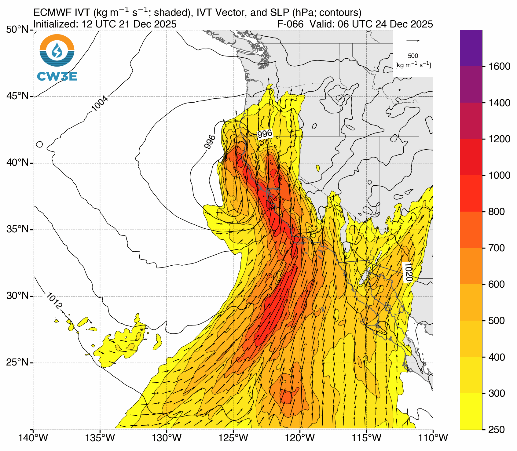
All of this will change rather dramatically, however, by later on Tuesday in Northern California and by early Wednesday in Southern California. A deepening surface low west of the SF Bay Area will phase with the ongoing warm/moist atmospheric river later on Tuesday, bringing a dynamic and strengthening cold front into NorCal Tuesday night and SoCal Wednesday morning. Unlike the relatively gradual/mainly orographic rains from this extremely warm AR thus far in NorCal, the Tue/Wed storm will be much more “dramatic”–bringing heavy rainfall and strong, gusty winds to most areas (including both NorCal and SoCal). There may also be some thunderstorms associated with this front, and the storm to follow (more on that below). And finally, once the cold front moves through later Tue into Wed, temperatures in the Sierra Nevada will finally crash–allowing snow levels to plummet to much more reasonable levels (likely 5-6k feet for the rest of the week thereafter).
Flood risk widespread but generally low-severity in NorCal; Potentially more serious flood concerns in SoCal on Wed
Overall, it appears that there will essentially be two precipitation maxima associated with this week’s California storms: one extending from Mendocino County northeastward into the Shasta/northern Sierra region and another across SoCal’s Traverse Ranges (and some portions of the northern/central coastal plain below). The NWS has issued Flood Watches for much of the state, and I would actually expect these to expand further later this week to encompass almost everyone. But the magnitude of flooding expected in NorCal is, for the most part, pretty modest–mostly rapid within-bank rises or minor flooding on smaller rivers, scattered urban/road/small creek flooding with the cold front on Tue-Wed, and probably some rockslides/mudslides in steep terrain. In SoCal, however, there is more concern regarding the potential for a window of more significant flood risk.
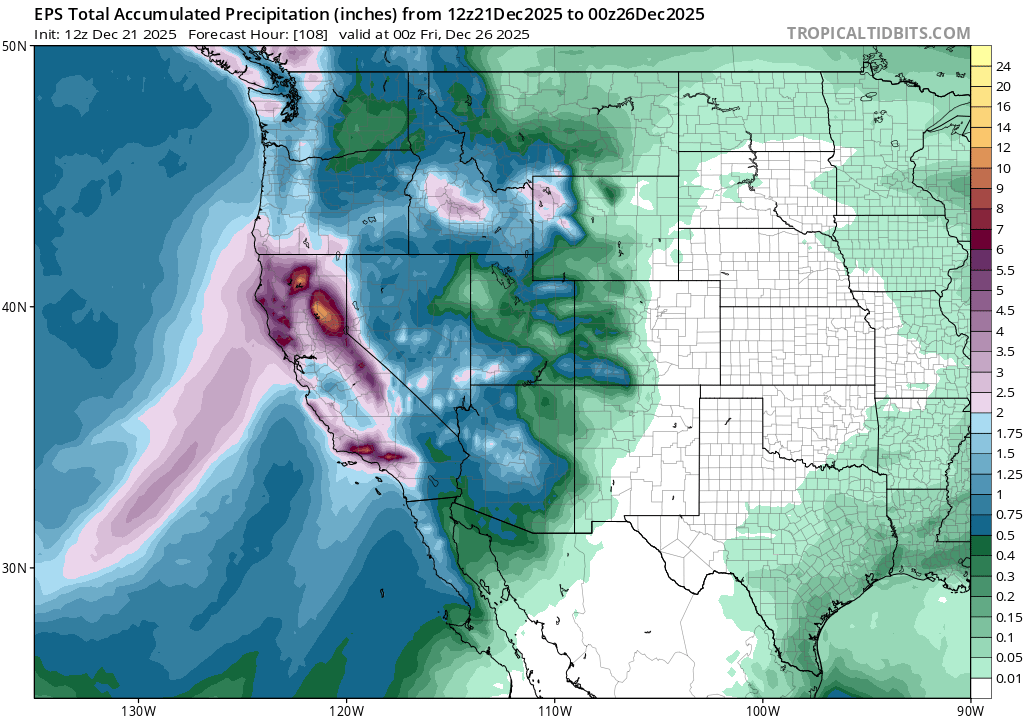
In SoCal, conditions have been dry in recent weeks (a mitigating factor). But soils will nonetheless saturate fairly quickly in many areas following exceptionally wet conditions in Oct-Nov (record wet, in some locations). And more importantly, a very strong cold frontal passage is expected on Wednesday–bringing a 2-6 hour period of widespread heavy and locally intense rainfall with some embedded thunderstorms. That will likely be enough for at least some flash flooding and debris flow to occur, mainly in steeper terrain and near recent wildfire burn areas, but also fairly widespread urban/roadway flooding during daytime on a major holiday travel date. So, all things considered, this could be a pretty high-impact rain event in SoCal.
There will be a secondary front, late Wed into Thu, that will again sweep from NorCal toward SoCal and bring an additional but briefer period of rain (locally heavy) during that window. Although precipitation totals with this shorter and colder second wave will be much less than the first, it may also be associated with locally torrential downpours from convective activity and isolated thunderstorms in a fairly unstable airmass. So although widespread flooding is less likely with this second round vs the first, there could nonetheless be some localized hydro issues again Wed night into Thu.
Strong, gusty winds from surface low off of NorCal and probably also some isolated thunderstorms (some strong)
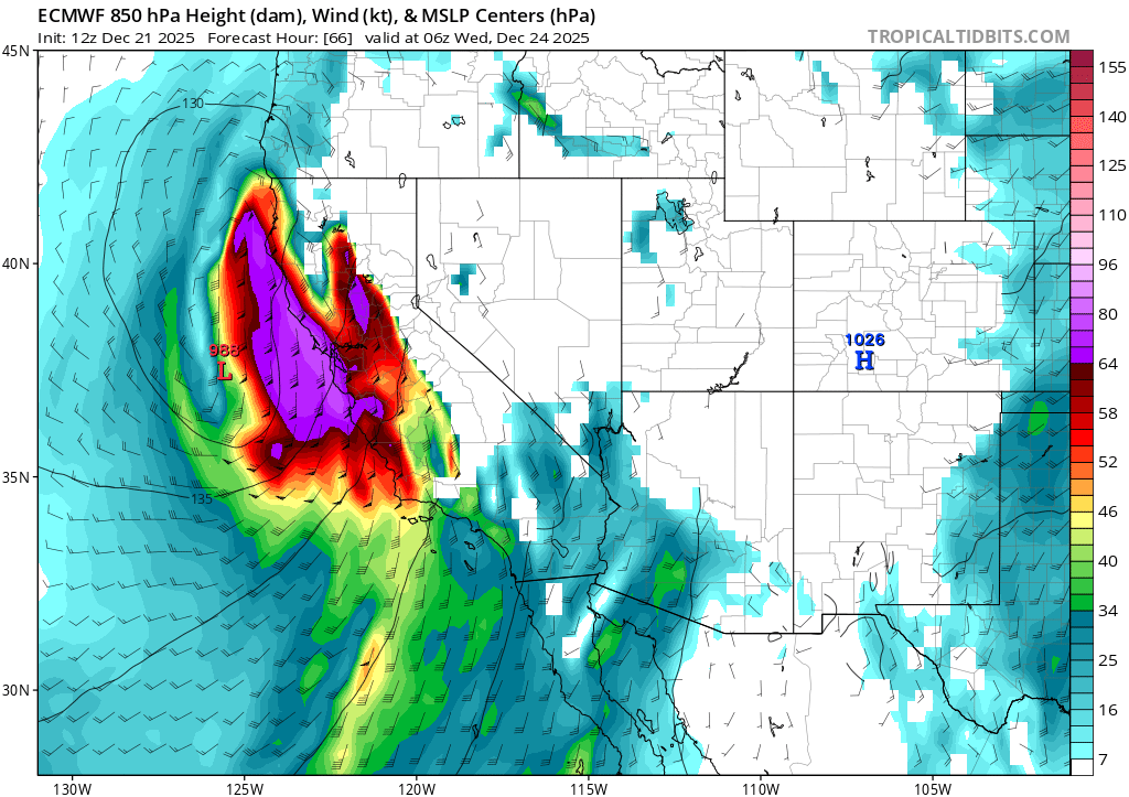
The Tue-Thu period will also feature periods of strong and gusty winds, especially in coastal NorCal but also extending locally inland and across portions of SoCal. There is presently some uncertainty regarding the magnitude of wind gusts along the CA coast from about Monterey northward to the Oregon border due to inter-model differences regarding the degree of deepening of the offshore surface low–which will be pretty close to the coast as it makes its closest approach. Right now, I’m thinking “strong, but not extreme” wind gusts are most likely across the SF Bay Region, with widespread gusts of 40-50 mph and higher gusts over 60 mph in the usual locations (exposed ridgelines and along the immediate coast). But there is some potential for even stronger gusts, especially along the immediate coast. These winds will be enough to possibly cause some downed tree branches and lead to scattered power outages, but the greater impact will likely be to road and air travel later Tue into early Wed and then again late Wed into early Thu. The wind forecast is subject to change considerably if the surface low evolution is a bit different than expected, so stay tuned!
Finally, as noted above, there will be a notably elevated possibility of thunderstorms will all incoming systems this week. Strong dynamics associated with the cold front and later subsequent spokes of vorticity moving ashore, combined with much colder air aloft and exceptionally warm surface temperatures (especially near the Pacific coast and offshore, as ocean surface temperatures remain exceptionally above average along the entire CA coast) will create an unstable atmosphere favorable for deeper updrafts and stronger convection. I would not be surprised to see a few strong to severe thunderstorms, mainly along the coast, at times from late Tue into Thu. The main risk would be locally strong/damaging winds (stronger than the broader wind field would suggest) and also locally torrential downpours (leading to some flash flood risk, especially in SoCal) , but a brief waterspout or tornadic spin-up can’t be ruled out. I’ll be watching this possibility of strong to severe thunderstorms over the next 48 hours as this system develops.
Exceptional Sierra Nevada warmth and record low snowpack to start week, but much colder air and heavy snow by Thu
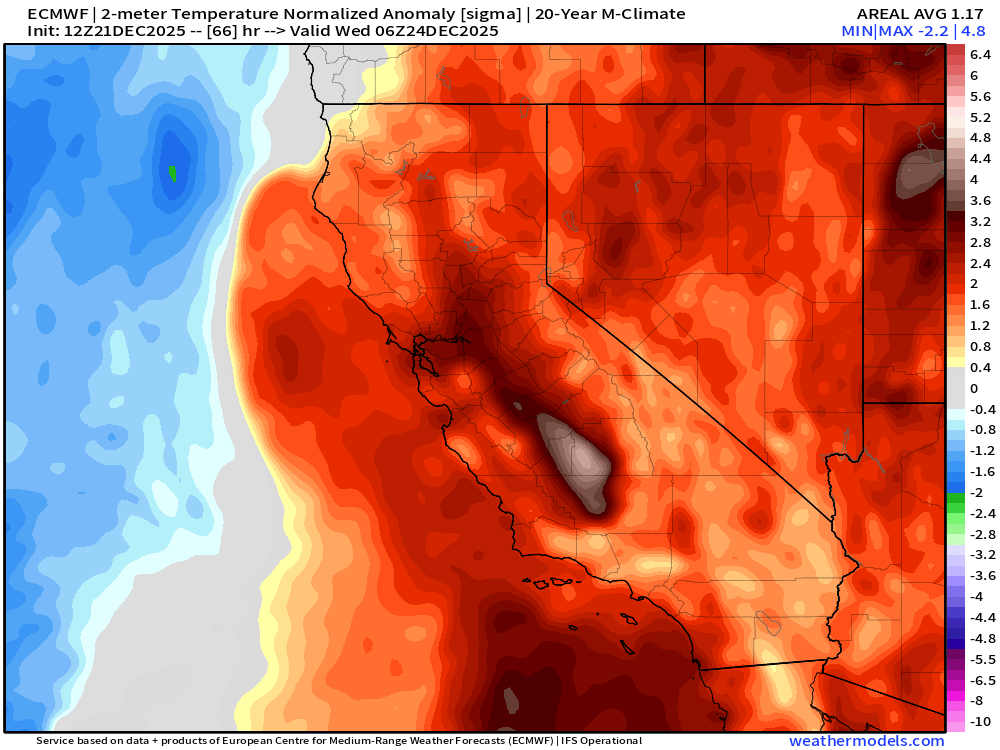
Finally, I just wanted to take a moment to emphasize how remarkable the ambient warmth of the current airmass over California–and much of the West–actually is. Even amid widespread rainfall, temperatures across NorCal are far above average and are keeping mountain snow levels exceptionally high. Rain has been occurring today as high as 10-11k feet in the northern/central Sierra, and as high as 12-13k feet in the Southern Sierra. That means that only the tops of the very highest peaks of the Southern Sierra have been seeing snow today, as opposed to rain virtually everywhere else.
Snow levels will remain extremely high–8k to 10k feet or even higher–until early Wednesday when they will (finally!) begin to fall behind the strong cold front. Until then, nearly the entire Sierra will see rain (quite heavy, in some cases, which will further erode whatever snowpack remains below 9-10k feet). From early Wednesday onward, however, a much more seasonable airmass will allow snow levels to fall considerably to around 6k feet (or locally lower). That means that Lake Tahoe and surrounding ski resorts should finally see meaningful snowfall during this period–and that the high Sierra will see very heavy snowfall in the multiple feet. So…for the next 48-72 hours, warm rains will continue and most of the mountain chain will be rebuilding its snowpack essentially from scratch. But I promise that Sierra snow is coming later this week!
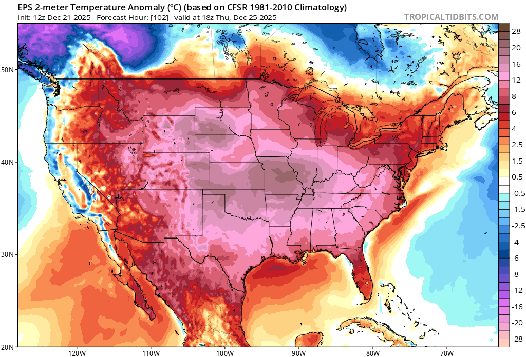
Once the colder system finally moves into California by mid-week, scouring out this record warm and also very moist airmass, historic warmth will shift eastward. As a result, the Central U.S. will likely see its warmest December 25th (Christmas Day) on record, and in fact due to the fact this anomalous warmth will extend nearly from the Pacific to Atlantic coasts it’s quite possible this will be the warmest Christmas on record for the contiguous U.S. This huge region of (quite frankly) ridiculous warmth will likely persist until and past the new year–before possibly expanding back westward toward California again in early January (for now, that last bit remains TBD).
Live virtual office hour to discuss incoming storm, flood risk, snowpack, and NCAR
I’ll discuss the upcoming storm activity, associated flood risk, the remarkable upcoming mountain snowpack transition, and also offer an update on recent news surrounding threatened dismantling of the NSF National Center for Atmospheric Research (NCAR) during a lunch hour livestream on Monday, Dec 22 (noon Pacific Time). See you there!
Discover more from Weather West
Subscribe to get the latest posts sent to your email.