Recent Weather Summary
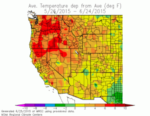
California experienced a cooler-than-average May in 2015–becoming the first month with below average temperatures in many months. However, those comfortably cool spring temperatures are now long gone, and June has turned out to be a very warm month across nearly the entire state. Several heat waves have brought very hot temperatures at times, and the warmth has been especially relentless across parts of the Central Valley, where the number of 100-degree days so far this calendar year already exceeds the total experienced during some recent full summers!
Impressive (and, in some cases, record-breaking) warmth has, in fact, expanded to encompass nearly the entire West Coast of North America, from Alaska to Northern Mexico. Large swaths of the Pacific Northwest and British Columbia are on track to experience their warmest (and, in some cases, driest) June (and combined May-June periods) on record. Fire season, despite getting off to an unexpectedly slow start in some regions, has roared to life in recent weeks–especially in California, where a number of large wildfires are currently spreading.
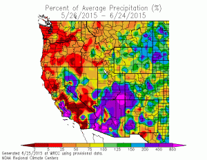
June has also been a fairly active month precipitation-wise. An active thunderstorm pattern has been in place for much of the month in the Sierra Nevada, with more widespread showers and thunderstorms occurring earlier this month in association with the remnants of East Pacific Hurricane Blanca. Precipitation from remnant East Pacific hurricanes is not all that rare in the late summer and fall months in California, but it certainly is in the first half of June–and this may be a portent of things to come later this summer, since sea surface temperatures off the west coast of Mexico remain far above average.
A powerful Western ridge builds; will bring prolonged period of heat (and local thunderstorms)
Those looking for a relief from the heat along the West Coast won’t like this outlook: an already strong ridge is expected to strengthen further and expand to encompass much of the Western U.S. (and also western Canada) in the coming days.
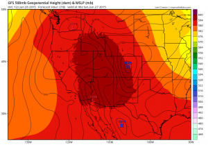
A very persistent region of southeasterly flow will remain anchored over California for the foreseeable future, bringing nearly unbroken heat to far inland areas, frequent periods of mountain and desert thunderstorms, and occasional coastal heat waves (and, perhaps, occasional chances for elevated convection and thunderstorms across California’s lowlands). Large-scale anticyclonic circulation over the Desert Southwest is to be expected during the summer months, but the upcoming pattern will be an unusually strong, expansive, and persistent version of the familiar “4-Corners High” that typically pops up each year during the North American Monsoon.
The next surge of heat and possible thunderstorms will occur today through this weekend. Hot temperatures can be expected nearly everywhere Friday and lingering inland into Saturday, before brief cooling occurs early next week. More concerning is the increasing risk of thunderstorms across nearly all mountainous regions in the state–not only across the Sierra Nevada but also including the coastal ranges. There is some risk that elevated convection (and associated lightning with little/no precipitation) could occur in lower elevation spots over the next few days, though at the moment this risk looks very modest. More widespread dry or nearly dry lightning is possible over the Northern and Eastern Sierra Nevada, where Red Flag Warnings are currently flying.
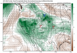
Additional surges of heat and possible convective activity will continue for at least the next 7-10 days as the strong ridge waxes and wanes slightly, and as spokes of energy (and possibly an easterly wave or two) rotate clockwise around the high. Mountain thunderstorms will be fairly widespread throughout the period, and the models appear to be keying in on a period of increased risk for coastal/valley convection around the July 4th weekend (which would obviously present huge fire weather concerns). Additionally, total atmospheric moisture will remain consistently elevated over California for at least the next 10 days, meaning that heat index values will be high than usual and overnight low temperatures may remain uncomfortably elevated. The details of this pattern are hard to discern more than a few days in advance, but all in all it looks like our relatively active summer weather pattern in California is set to continue.
Extreme fire weather conditions to worsen
Dire prognostications about the 2015 fire season have (fortunately) not yet come to fruition. An unusually cool May in California and an unusually wet early spring in the Pacific Northwest helped to temper the early season fire potential.
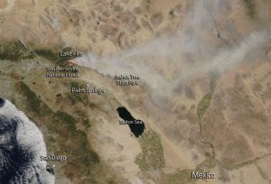
The situation is rapidly changing for the worse, however, and there has been a huge surge in fire activity across California over the past two weeks. With a prolonged, widespread heatwave in the forecast for the West Coast with co-occurring lightning outbreaks, fire season is likely to shift into very high gear in the coming days. Given the extremely dry state of fuels due to California’s exceptional multi-year drought (and the also exceptional “snow drought” in the Pacific Northwest and British Columbia), large fire potential will be quite high for the foreseeable future. It’s also worth noting that the peak of California’s traditional fire season is still a couple of months in the future–from later in August through early October.
A brief mid-summer outlook
Looking forward into July: long-range outlooks suggest the potential for a rather active pattern to persist for much of the summer in California and across much of the American Southwest. The CFS currently foresees far above-normal chances of precipitation along the CA coast during July, though it’s important to keep in mind that average precipitation this time of year is near zero, so even a small amount of rainfall would lead to far above-average totals in a relative sense.
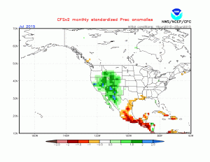
It’s not clear at the moment whether this unusual warm season precipitation signal is coming from an active monsoonal flow pattern (which we are currently experiencing) or from more tropical sources (in the form of remnant energy/moisture from the eastern Pacific Ocean). Hurricane season in the East Pacific has already gotten off to a record-breaking and hyperactive start–and this high degree of activity is expected to continue for the rest of the summer and fall as ocean surface temperatures remain exceptionally warm. It is worth noting that summer during which strong El Niño conditions are in place tend to feature at least a handful of interesting warm season weather events in California.
Micro El Niño update
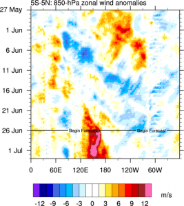
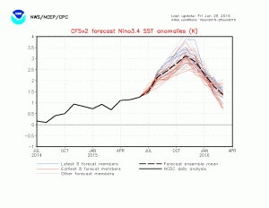
With each passing week, it seems more and more likely that the world will experience a strong El Niño event in 2015. We’re almost there already–observed conditions are right at the official threshold for declaring a “strong event.” All major dynamical models suggest further strengthening, and several of the best models are still suggesting the potential for quite a bit of additional strengthening.
The latest runs of the CFS are continuing to call for the strongest El Niño event on record by the fall months–and this is starting to look more plausible as we have now mostly emerged from the so-called Spring Predictability Barrier. As of this writing, a new, powerful westerly wind burst was just beginning in the far West Pacific–a very strong sign that a third major Kelvin Wave may be on the way and that this El Niño event will continue to intensify for at least the next 3 months. I’ll continue to follow El Niño developments–in addition to California’s unusually active warm season weather conditions–through the summer. Stay tuned!
© 2015 WEATHER WEST
Discover more from Weather West
Subscribe to get the latest posts sent to your email.