Hurricane Hilary will weaken dramatically on approach, but will bring major and even historic impacts in some parts of Southern California

I’ll waste no time in this introduction except to say: the possibility of “interesting weather” from the remnants of tropical storms I mentioned in the last post is certainly coming to pass, and in rather dramatic fashion! Hurricane Hilary is now churning over the far eastern Pacific Ocean southwest of Baja California–currently a Category 4 storm with sustained winds of 130 mph or greater. It rapidly intensified yesterday into a major hurricane, and is likely peaking in intensity as of this writing. Beginning later tonight or certainly by tomorrow morning, Hilary will begin a rapid weakening trend as it starts to accelerate north/northwestward–essentially paralleling the coast and making a bee line for Southern California. As the storm moves away from warm tropical waters and into an ambient atmosphere that is rather hostile to warm core (tropical) cyclones, Hilary should drop below major hurricane status and below hurricane status (defined as having sustained winds of at least 75 mph) by Sunday afternoon.
However, because of Hilary’s fast forward speed and its presently great intensity, the storm will not have time to completely “spin down” before it reaches Southern California. In fact, it may retain tropical storm strength and characteristics as far north as San Diego or even Los Angeles–meaning that there is a substantial possibility (at or above 50%) that California will experience its first landfalling tropical storm since such a storm made landfall near Long Beach in 1939. In a notable historic first, the National Weather Service and National Hurricane Center have jointly issued a Tropical Storm Watch for much of Southern California, including the entire coastline from San Diego up through Ventura County as well as some additional mountainous regions. (The service as it existed back in the 1930s did not issue such warnings.) The only other known tropical cyclone to actually make coastal landfall in California was the 1858 San Diego Hurricane. There have been other tropical cyclone remnant events (as recently as Kay last year in 2022, and memorably for some folks Kathleen in 1976) that have brought major summer storm and flood-related impacts over the decades, but in terms of actual tropical cyclone landfalls, Hilary would be only the third in California since the mid 1800s and the first in the era of SoCal’s massive population growth.
Greatest risk, by far, will be severe to “catastrophic” flash flood risk in eastern San Bernardino and San Diego counties as well as high/low deserts along an axis from Calexico to Death Valley

Significant summer rainfall is likely throughout Southern California during this event, and some rain will fall across portions of central CA as well (though chances will be highest south and east of Sacramento and the SF Bay Area). Fairly widespread heavy rainfall of 1-3 inches will fall west of the mountains in SoCal, but dramatically heavier totals could accumulate in the Peninsular Ranges and in both the high and low deserts. Widespread totals on the eastern slopes of the SoCal mountains and in some orographically favored parts of both the high and low deserts could be in the 3-7 inch range, with local totals well in excess of 10 inches possible. The heavy desert rainfall will actually come in two waves–the first in the form of a very rare (for CA) tropical “predecessor rain event” (PRE) that will begin by Sat PM in the SE portion of CA, and a second (and likely more intense) wave associated with the actual tropical storm itself on Sunday into Monday.
3-10+ inches of rainfall might represent an impressive but hardly historic rain event on the south-facing slopes of the Transverse Ranges of SoCal. But on the eastern slopes and in the desert, this represents an astonishing amount of water. Some desert locations along an axis from the Imperial Valley to Death Valley may see anywhere from 1-3 years’ worth of precipitation in just 2-3 days. As a result, the risk of widespread flash flooding is high. Much of this flooding will go far beyond “nuisance” level (i.e., ponding and flowing washes) and has the potential to reach major to catastrophic/historic levels locally (I’m borrowing language directly from NOAA here). That means that life-threatening inundation of both low and high desert regions is likely, and that major damage/destruction of infrastructure–including major roads and highways–is possible in the hardest hit areas. Death Valley and Joshua Tree National Parks in particular could be very hard hit, though all populated areas east of the mountains are also at very high risk during this event.
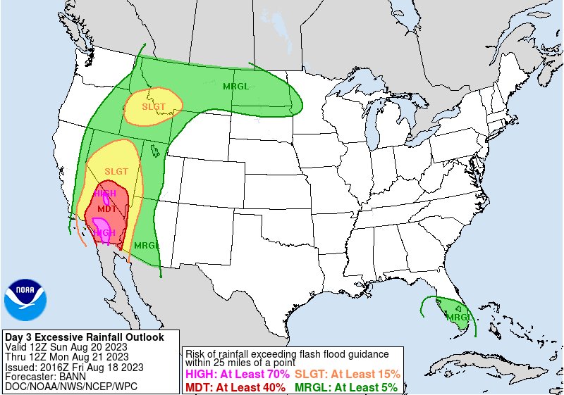
Flooding could match or exceed that experienced in SE CA during Kathleen in 1976 in some areas. 100+ year floodplains and debris flow/alluvial fansheds could locally become active. This has a high potential to be a very serious and widespread flood event in the SE CA deserts, and I would strongly advise anyone potentially in harm’s way in this region to prepare accordingly. If you live near streams/washes/debris flow corridors that have been active at any point in recent decades, or in some cases even well outside of them, you could potentially be at risk during this event.
Lesser flooding (mainly road flooding and minor to moderate small stream flood issues, plus the possibility of debris flows–things SoCal sees every year, though rarely in August) is likely in the SoCal metro areas–the exact magnitude of which will depend on the precise track of the low pressure center. I do not believe this will be an extreme/historic flood event for the LA/San Diego areas. But it could very well become so for areas in and east of the mountains (i.e., the Transverse and Peninsular Ranges), so there may be a pretty sharp contrast in impacts.

Some fascinating related trivia: Hilary will likely bring both the moistest airmass (in terms of column precipitable water) and the largest water vapor fluxes (i.e., IVT–more commonly used to quantify atmospheric rivers) ever observed in SoCal during summer–and possibly at any time of year.
Lesser but still notable risk of strong and gusty winds along the coast and in SoCal mountains as well as minor storm surge and high surf
Tropical Storm Watches are in effect for–you guessed it–the potential for widespread tropical storm force winds. Technically, that includes sustained winds from 39-74 mph–but I would strongly suspect that they will mostly end up at the lower end of that range, especially at lower elevations. However, widespread gusts of 35-60 mph are not out of the question, and some mountain areas could see much stronger gusts (similar to what occurred during Kay’s near miss last summer, when the mountains of SD County saw gusts over 100 mph). I don’t generally expect to see widespread significant wind damage from this storm, though some minor damage and power outages are certainly possible.
These wind impacts, as well as oceanic effects, will depend greatly on the exact track of the low pressure center. If it tracks east of San Diego, into far northern Baja CA, wind impacts will be greatly reduced for coastal SoCal but increased in the Imperial Valley. Likewise, the occurence of unusual southeasterly swells and perhaps a 1-3 foot minor storm surge could cause coastal flooding issues–including in some unusual spots, like the east-facing sides of the Channel Islands. Generally, however, I strongly suspect inland flooding from potentially extreme rainfall will be by far the greatest hazard associated with Hilary.
Possibility of locally severe thunderstorms and isolated tornadic spin-ups
Tropical cyclones often feature swirling bands of convection (squall lines) that rotate around the center of the storm (the eye)–and Hilary will likely be no exception. The storm may lose much of its deep convection before arriving in SoCal, but there will probably still be at least a few intense bands of showers/thunderstorms swirling around the center. These bands could contain lightning and wind gusts over 60 mph–which would qualify as severe thunderstorms, as the NWS SPC has highlighted. Additionally, given the enhanced low level vorticity and local wind shear present in the TC environment, there will exist at least a modest possibility of a few isolated tornadoes or waterspouts over SoCal. These could occur essentially anywhere, but might be most likely near the coast of San Diego, Orange, or Los Angeles counties. While I don’t expect this to be a major/widespread phenomena, it could locally increase the risk of storm related damage or other impacts.
Why is such a rare event unfolding right now, meteorologically speaking?

There are typically three key barriers to tropical cyclones making landfall in California:
- Cool ocean temperatures. Warm, tropical oceans serve as “hurricane fuel,” and even in a warm year California’s near-shore ocean temperatures are far below the necessary threshold.
- Prevailing tropical easterly winds, which tend to steer East Pacific hurricanes westward into the open ocean (and away from California).
- A stable atmosphere, characterized by mean subsidence (i.e., downward-moving air on average) due to California’s position on the edge of the subtropics. An unstable atmosphere and upward vertical motion are required for the formation of clouds, precipitation, and storms.
The main reason why Hilary is going to make such a close approach is that barrier #2 is unusually weak due to a rare atmospheric circulation setup over North America. Due to the combination of a very large and (by the weekend) record-strength ridge of high pressure extending across the entire central third of the continent and a persistent cut-off low pressure system west of California, the usual east-to-west flow is inhibited and steering currents are instead oriented south-to-north over the Southwest. This anomalous flow will Hilary to get picked up in this poleward air current, coming directly over California.
A secondary reason is that, despite near-average coastal ocean temperatures in SoCal, barrier #1 is weaker than usual as well due to well above ocean temperatures in the primary tropical cyclogenesis region west of Mexico (waters are 2-4C warmer than average this month). This has allowed Hilary to become a formidable major hurricane, and that means the system will take longer than usual to weaken on its approach to CA.
An oft-asked question this week: will global warming increase the odds of landfalling tropical cyclones in California? My answer: It’s plausible, to a modest but probably not very large degree. However, there have not yet been any formal studies looking into this. So why do I say it’s plausible, but as yet undemonstrated? Well, warming oceans will probably somewhat weaken barrier #1. Oceans near California still won’t be warm enough to sustain tropical cyclogenesis even in a much warmer climate, but they may allow storms with a favorable trajectory to weaken less quickly (especially during strong El Nino years, like the present). The other two barriers, however, will likely remain largely intact–meaning that such events will most likely remain rare, but perhaps somewhat less so. (I’ll update this hypothesis in the future if relevant studies pop up!)
Follow me on YouTube (and Twitter) for real-time updates
I just finished a YouTube livestream this afternoon, and will likely do additional livestreams between Sat and Tue. All will be recorded and can be viewed after the fact. Exact times are TBD and will be announced later. I’ll also be active on Twitter to the best of my ability (although the extreme volume of hate messages, personal threats, and climate denial has become overwhelming in recent days and is now, for the first time, actively limiting my ability to use the platform as an effective tool).
Discover more from Weather West
Subscribe to get the latest posts sent to your email.