Short-term outlook: NorCal lightning outbreak likely
California’s very active summer pattern (see below) is set to continue over the next few days. As of Sunday afternoon, a well-defined cutoff low had set up shop about 150 miles northwest of San Francisco.
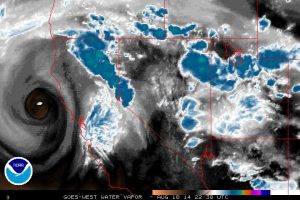
This low–which is rather deep for the late-summer months–has actually begun to retrograde (move back westward) while sending some spokes of energy northward around the east side of its circulation center. This low is quite moisture-starved, with convective activity thus far mostly confined to the west slopes of the Sierra Nevada and near Mt. Shasta. However, a few lightning strikes have recently been detected near the low center ~100 miles NW of San Francisco over the open ocean, which suggests that significant elevated instability is starting to overcome the very dry environment near the low center.
In many ways, the current setup closely matches the classic scenario for widespread late summer/early fall lightning events across Northern California. The deep, slow-moving offshore low is positioned favorably to maximize both instability and upper-level divergence, though (as mentioned previously) moisture appears to be severely lacking. The atmospheric forecast models have a relatively poor historical track record with these sorts of events, and this pattern is often recognized by California meteorologists one that has the potential to produce fairly widespread convection even if model forecasts do not explicitly project such activity. Thus, it’s tricky to say exactly where lightning will occur over the next 48-72 hours, but there’s an excellent chance that it will be fairly widespread and be associated with relatively little precipitation.
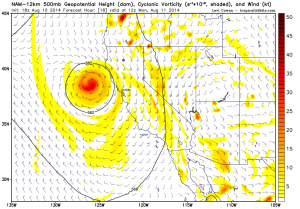
All of Northern California appears to be at risk of dry or marginally wet thunderstorms over the next 72 hours, and it now also appears that Southern California will be at risk of (mostly wet) storms on Monday and Tuesday (possibly including coastal and valley locations) as a subtropical moisture starts to become entrained into the far eastern periphery of the circulation. The San Francisco Bay Area may actually be sandwiched in between these two more favorable regions for convective activity and thus actually stands a lower chance of lightning over the next 72 hours, but I still think isolated storms will be possible given the proximity of the low and the tendency for the models to underestimate spatial coverage of convective activity in situations like this.
High risk of major wildfire outbreak next 72+ hours
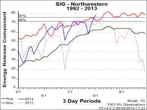
Wildfire activity in California has increased pretty dramatically over the past several weeks, especially in the far northern portion of the state. Most of these starts have been caused by lightning, and I expect to see many new ones spring up during and after the impending lightning event. Since vegetation in NorCal is near or exceeding record-dry levels and wildfire risk is exceptionally high for this time of year due to California’s extreme drought, this event could easily lead to a very significant and widespread wildfire outbreak in Northern California and also over much of Oregon. Wildland firefighters in the American West often speak of “lightning sieges” that occurred in various years, and it’s starting to look like August 2014 is headed in that direction for California and Oregon.
The North American Monsoon in 2014: unusually active so far
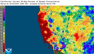
Recent weeks have featured many consecutive days of enhanced thunderstorm activity over mountain and desert regions in California (and occasionally elsewhere), bringing locally very intense rainfall and in at least once instance a remarkable and deadly flash flood event. A few localized regions in the Sierra Nevada and in the mountains of Southern California have picked up very substantial precipitation over the past two months–enough to locally and temporarily reduce wildfire risk in these regions. It should be noted that this recent precipitation, while locally impressive, has done very little to ease long-term drought conditions in California (and none of California’s major reservoirs have responded at all to these localized thunderstorm downpours).
Persistent ridging returns: a West Pacific legacy?
Nonetheless, this very active monsoonal pattern in California has been fairly remarkable for several reasons. First, it appears that a persistent middle-atmospheric ridge is once again favoring the West Coast of North America as it has for the better part of 18 months now. While the ridge amplitude has not recently been as high as during the heyday of the Ridiculously Resilient Ridge, the persistence of the present ridging over weeks (and even months) is once again eyebrow-raising. How has this RRR-like feature managed to stick around into the summer months this year, unlike last summer when it temporarily dissipated during the warm season?
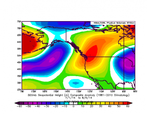
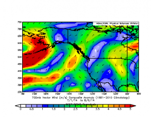
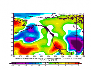
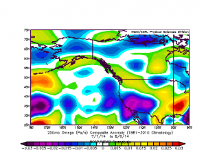
The answer may lie in the far western tropical Pacific, where a remarkable series of powerful typhoons have managed to develop and recurve into the extratropical mean westerly flow over the past couple of months. The injection of latent energy into upper levels of the atmosphere by West Pacific tropical cyclones is a fairly well-known mechanism for exciting an amplified atmospheric Rossby wave train over the downstream North Pacific Ocean, and this appears to be the reason why we’ve been so consistently locked into the now-infamous “North American Dipole” (Warm West/Cold East) pattern since late June.
Interestingly, the actual effects of persistent large-scale ridging in summer is quite different than in winter over California and across much of the Desert Southwest. Observations since July 1st suggest the presence of a very coherent pattern of increased monsoonal activity in these regions, including strong east-to-west wind anomalies, large positive moisture anomalies, and a remarkably large region of anomalous upward vertical motion. While the easterly/anticyclonic anomalies are similar to those observed in winter, the positive moisture and upward motion anomalies are opposite in sign, which is exactly what one might expected given the seasonal reversal in wind patterns that defines the North American Monsoon.
New typhoons are continuing to develop and recurve in the West Pacific, which suggests that a continuation of the North American Dipole pattern is likely for at least the next few weeks. Thus, I would expect there to be a continued chance for more a more active monsoonal pattern for the rest of summer (especially when combined with the fact that northeastern Pacific sea surface temperatures are far above normal).
Keep an eye (or two) to the sky!
© 2014 WEATHER WEST
Discover more from Weather West
Subscribe to get the latest posts sent to your email.