Summary of recent weather conditions
The past couple of weeks have been warm and dry across nearly the entire state.
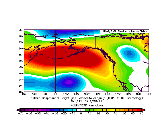
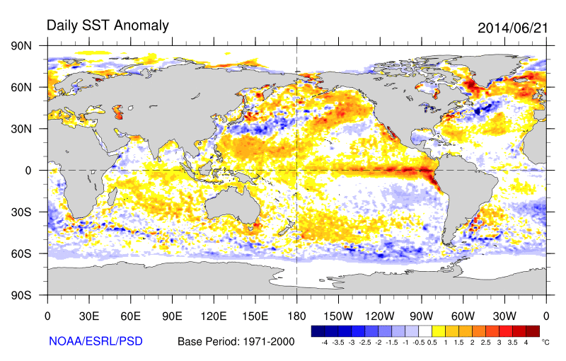
While no widespread major heat waves occurred, certain regions (particularly in the Sacramento Valley) did set new daily record highs on a couple of occasions since my last post, and most other regions have averaged at least several degrees above normal for this time of year. “June gloom”–or the marine stratus and low clouds that are typically prevalent near the California coastline during early summer–has been less extensive than usual so far this summer. On a possibly related note, sea surface temperatures (SSTs) are warmer than normal along the coast of Southern California (by as much as +3-4 F).
The near-term future: perhaps some showers, then a classic California heat wave
There does appear to be a bit of a temporary pattern shift coming to the East Pacific over the next few days. While the entire region has been dominated by a persistent ridge of high pressure and high atmospheric heights over the past several weeks (and, really, the past couple of months), an unusually strong trough and associated series of weak disturbances is expected to develop northwest of California later this week. The numerical models have been struggling considerably with this development, with a handful of ensemble member suggest the potential for some significant precipitation across Northern California by the end of June and the majority suggesting little to no precipitation. Disagreement–even between successive runs of the same model–remains high, so the forecast for the coming week in NorCal remains characterized by high uncertainty.
At the moment, the likeliest outcome appears to be the occurrence of some (probably light) showers across the northern third of the state later this week, possibly associated with isolated thunderstorms if stratiform cloudiness isn’t too thick to prevent surface heating. This event does not appear to be a repeat of last year’s rather extraordinary mid-summer atmospheric river event, which produced significant precipitation in regions unaccustomed to seeing such conditions during the typically well-defined dry season. Thus, a best estimate at the moment is that the primary effect of this week’s pattern change may be to very briefly reduce wildfire risk in the far northern reaches of the state, though this could be negated if lightning strikes occur or gusty winds develop behind the departing weak low pressure areas (which currently appears likely). That said, these sorts of disturbances bear watching during the summer months, since they are not favored climatologically and can occasionally lead to surprises.
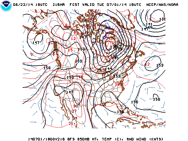
There’s actually more confidence in the long-term forecast at the moment, since there have been pretty consistent signals in the models over the past week or so that a rather large and intense region of heat associated with strong ridging over the Desert Southwest/Four Corners region will develop by early July. California will be on the northwestern periphery of this big ridge (as is typical for this time of year). This pattern will likely be conducive to persistently hot/very hot conditions inland and occasional bursts of hot conditions closer to the coast, especially in Southern California. Also: while it’s still pretty early to be talking about monsoonal moisture incursions into the Golden State, it does appear that some southeasterly flow may develop during week 2 of the current forecast cycle and thus I would not be entirely surprised to see some early-season mountain/desert thunderstorms around the 4th of July weekend.
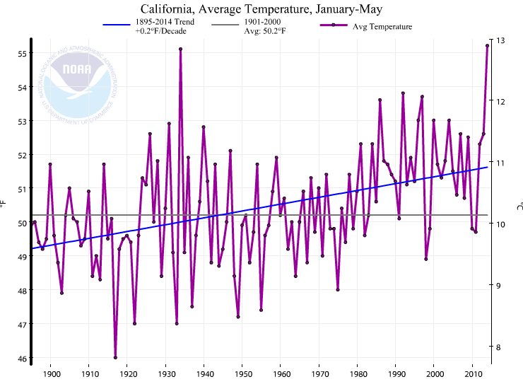
2014 California’s all-time record warmest year to date; exceptional drought region expands
California’s exceptional drought continues to make national and international headlines, and for good reason. 2014 has been (and remains) California’s warmest year to date in at least 118 years of record-keeping (and this follows the superlative warmest winter on record in 2013-2014). While the Water Year totals are not year in, 2013-2014 is destined to be among the top 3 driest Water Years on record, and this follows the all-time driest calendar year on record (by far) in 2013.
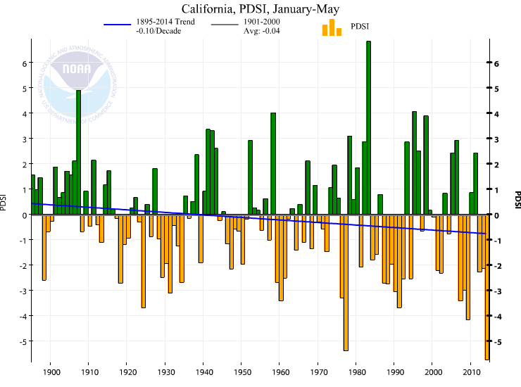
Parallels have increasingly been drawn between the current event and both the much-remembered mid-1970s drought and the less-remembered but perhaps even more intense 1930s drought (which was associated with a much broader event across much of North America, including the devastating Dust Bowl conditions in the Great Plains). Given the fact that conditions during the present event are occurring in the broader context of record-warm temperatures–with associated record-high evaporation and soil/vegetation dryness–by some measures the hydrological intensity of the current drought is exceeding that of any recorded historical drought in California. And it’s also worth keeping in mind that we don’t yet know when the current drought will end: as many have noted, even a wetter-than-normal winter in 2014-2015 would almost certainly not be able to erase the phenomenal water deficits that currently exist around the state.
El Niño update: the tropical atmosphere might finally be getting its act together
The evolving El Niño event in the tropical Pacific Ocean continues to garner considerable media attention, and along with this heightened level of interest has come a rather wide array of dubious and often conflicting information. What follows is a quick recap of the relevant events thus far.
In early 2014, a very strong (and possibly record-breaking) oceanic Kelvin wave was initiated by a series of westerly wind bursts in the western tropical Pacific Ocean. The downwelling (warming) portion of this slow-moving wave propagated eastward towards the western coast of South America during the spring, and the warm temperature anomalies associated with this wave have now surfaced in the East Pacific. Substantial positive SST anomalies developed in April and May in the vicinity of the Galapagos Islands, and have since expanded in all directions (but most notably back westward along the equator). At the same time, westerly wind anomalies decreased in the West Pacific (with a total absence of observed synoptic-scale westerly wind bursts), which means that no new Kelvin waves have been generated since the very large one earlier this year. There has been some recent concern that the atmosphere was not reflecting the developing El Niño conditions in the tropical ocean, and some have suggested that this may be a sign that El Niño’s development may have stalled or even fallen apart. Coupled ocean-atmosphere model projections suggested a slight weakening in the expected intensity of El Niño conditions to be observed during fall/winter 2014-2015.
However, over the past week, a remarkable (and rather surprising) rise in SST anomalies across much of the equatorial East Pacific Ocean caused the Nino 3.4 Index (the SST index typically used to characterize the state of ENSO) to rise well above the El Niño threshold of +0.5 C: the value on June 21st now stands at +1.05 C. This value is well above that projected by most models to occur for the rest of the summer. While the possibility exist that this is merely a transient spike in SST and that ocean surface temperatures will decrease again before rising later this summer, this may be a suggestion that the dynamical models are underestimating the potential strength of the developing event.
Another piece of interesting news on the El Niño front is that the large-scale atmospheric conditions in the tropical Pacific appear to be becoming rapidly more favorable for the development of westerly wind anomalies (and bursts) over the coming weeks and thus in reinforcing the developing warm SST anomalies in the canonical El Niño region. While considerable uncertainty remains, most models currently project an eastward propagation of the Madden-Julian Oscillation (sidebar: the MJO is the predominant mode of intraseasonal atmospheric variability in the tropical Indian/Pacific oceans) signal into the West Pacific, which would provide additional evidence of El Niño’s impending reinforcement. Should these forecasts indeed come to pass, a new equatorial Kelvin wave will likely be generated, which would help to reinforce El Niño toward the end of summer just when reinforcement will be most needed. Very recent model projections appear to be taking this evolution into account, since there has once again been an upswing in projected Nino 3.4 region anomalies for the fall/winter months.
What is the most important message at the moment regarding El Niño? Well, El Niño is essentially already underway, though its potential intensity during the fall/winter months remains uncertain. While the dynamical models project a peak likelihood of a moderate-strength event, a strong event remains eminently possible given recent atmosphere/ocean observations and the possibility that even our best models may have a tendency to under-predict strong El Niño events. Finally, as I’ve pointed out frequently in the recent past: El Niño generally does not equate drought relief in California, though a particularly strong event would most likely prevent another dry year from occurring. And either way, the fact remains: we’ve still got a long, dry summer ahead. Stay tuned.
© 2014 WEATHER WEST
Discover more from Weather West
Subscribe to get the latest posts sent to your email.