Recent conditions: mercifully cool and damp in NorCal, but severe drought is intensifying once again
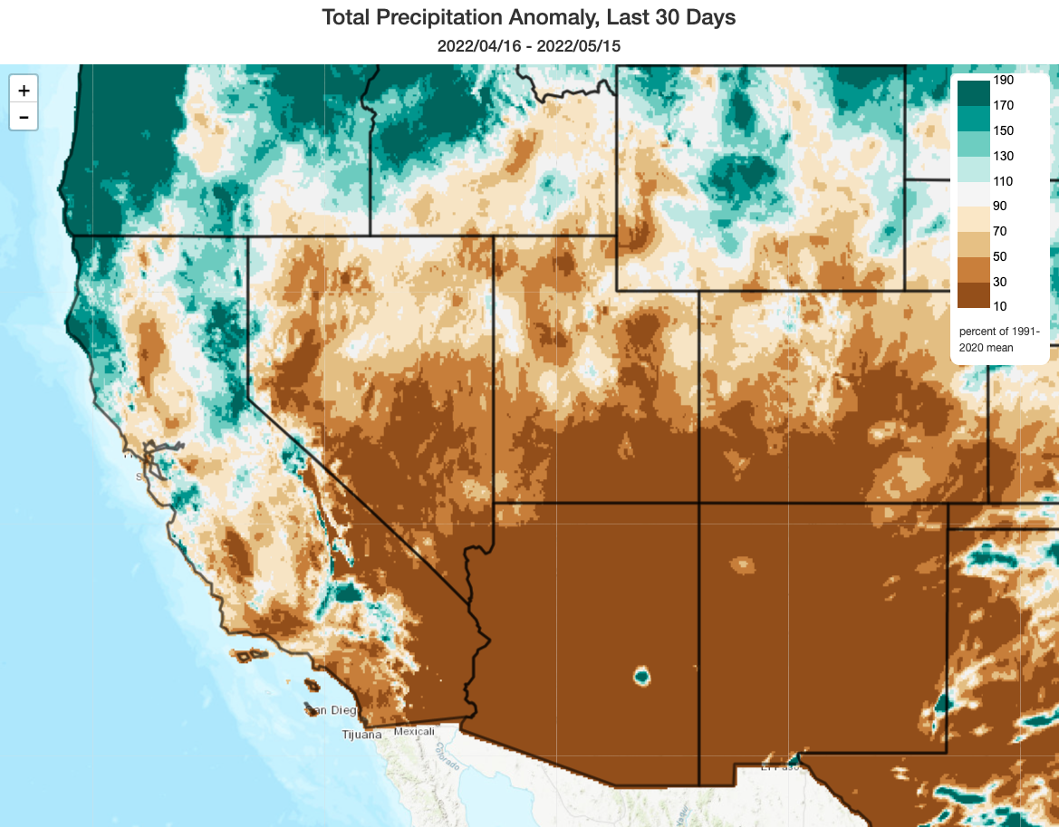
It has been a truly bizarre Water Year thus far in California. With all-time record wet conditions in October in Norcal, followed by very snowy conditions in the Sierra during December, then all-time record dry and warm conditions during the height of the erstwhile “wet season” from January though March throughout much of the state, just about everything has occurred out of seasonal order and in rather bewildering sequence. Most recently, NorCal actually witnessed a 30 day period with near to slightly above average precipitation (!), but perhaps more impressively a very anomalously cool and windy period as well. In fact, some places along the North Coast saw their coolest April and early May period in at least 40 years! We don’t see weather like that too often these days.
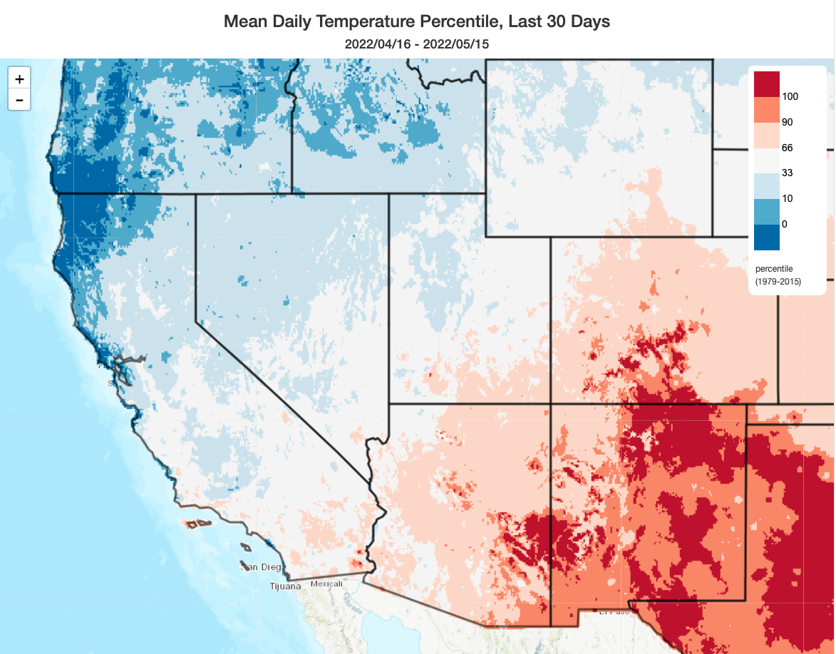
Despite the winds, this precipitation combined with cool temperatures helped to (temporarily) defuse what is otherwise looking like a severe fire season in northern California. And it did, briefly, also help to stem the dramatic snowpack losses that have been occurring since December. But that effect has not persisted, since today’s measurements suggest statewide snowpack is already down to only 17% of average (and only 7% of average in the southern Sierra). This is consistent with multiple overall indicators suggesting that despite the recent precipitation and coolness, California’s drought has actually intensified overall since December.
Persistently warmer and drier weather on the way for second half of May
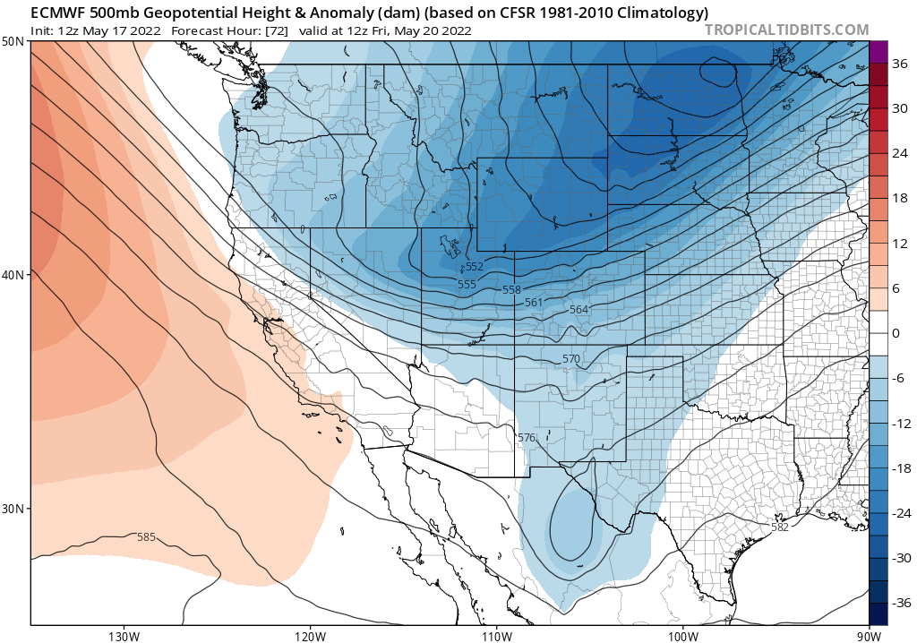
The relative dampness and coolness of recent weeks does appear to be largely in the rear view window, especially across inland areas. Conditions this week will remain on the reasonably mild side before warming up considerably next week as a subtropical ridge builds across the northeastern Pacific, with the season’s first triple digits expected across inland valley areas (and some model members are suggesting the potential for a more intense heatwave, but that isn’t the most likely outcome at this time).
Before that pronounced warming trend next, though, an Inside Slider-type system will bring a ~48 hour period of strong & gusty north winds to NorCal, along with a very dry airmass. This will dry out drought-stressed vegetation in a hurry, and will lead to a fairly sudden and dramatic increase in wildfire risk.
At the moment, warmer than average conditions appear likely to persist through the end of May, and most places in CA will remain completely dry during that period. The low/zero precipitation is really not all that unusual for the time of year, though conditions will probably be anomalously warm.
Thoughts about the summer to come: another year of extreme inland heat but relatively mild coast?
Now that summer is rapidly approaching, I thought I’d offer a few thoughts. First of all, it is now very clear that La Niña conditions are going to persist across the eastern tropical Pacific Ocean through the summer, and most likely into the autumn. Historically, this would have increased hopes of a slightly cooler than average summer, but long-term warming has wiped out that previous relationship. There is, however, for this reason a stronger signal that Arizona and New Mexico might see a decent monsoon this year–which would perhaps offer some modest mid-summer drought relief there. Then there is the legacy of the expanding and intensifying multi-decadal “megadrought” over the continental interior of the American West–bringing extremely dry antecedent soil conditions and low mountain snowpacks to start the season.
Putting all of that together, what am I expecting? Well, in California overall, I would expect this to be yet another warmer than average summer (when is it not, these days?), but there’s a pretty good chance we’re going to see another “bifurcated season” where places more than 20-30 miles from the coast are frequently very hot but conditions right along the immediate coast may actually end up close to average due to a robust marine layer and onshore flow. As in several recent summers, this might lead to a situation where much of the land area of California experiences record/near record heat but most of its coast-centic population does not. In other words: I think it’s likely we’ll see further amplification of the pre-existing “cool coast/warm inland” pattern that typically occurs during California summers. That, of course, has major implications for wildfire risk, since peak summer burning conditions usually occur precisely in those regions expected to be most anomalously hot and dry (i.e., the Central Valley foothills, Sierra Nevada, and southern Cascades).
Although it’s impossible to predict dry lightning events weeks/months in advance, this will definitely be something to watch out for later this summer/fall, since vegetation may once again be approaching record dryness levels by July/Aug and will be very receptive to lightning ignitions.
The immediate coast has a much higher likelihood of becoming hot/warmer than average during late summer/early fall–once again, an amplification of the usual seasonal cycle. At this time, wildfire risk will expand westward to include the coastal forests as well as the inland ones–and there is some potential for an enhancement of offshore winds (once again) this coming fall if La Niña persists, as is now favored.
I won’t spend any time considering next winter at this point, since it’s just too early. But there are some growing signs of a very rare “triple dip” La Niña continuing into its third Water Year–which would have significant implications for California and the rest of the West.
And finally, in case you missed it, a spectacular weather image from Oklahoma
Discover more from Weather West
Subscribe to get the latest posts sent to your email.