Overview of recent conditions: exceptional drought continues
Warm and dry conditions have been the rule across California over the past two weeks, with the exception of a few high-mountain springtime thunderstorms fueled by weak atmospheric disturbances and moisture from melting of the meager Sierra Nevada snowpack.
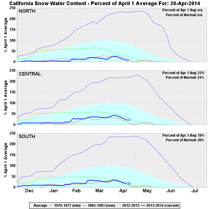
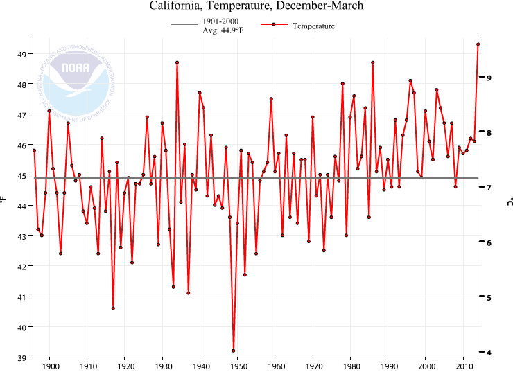
The recent rate of loss of snow water equivalent (SWE) in the Sierra Nevada (since April 1st) is among the highest on record, which has acted to push the already exceptionally low snowpack water content back into record territory. In fact, the Northern Sierra SWE currently sits at 9% (!) of normal for this time of year–yes, you read that correctly: fully 91% below average. The state-wide average is modestly higher–at a positively bountiful 19% of average–but these incredibly low values are likely to translate into record-low inflows into the state’s reservoirs over the next several months and peak streamflow/runoff values that occur much earlier in the year than has historically been observed. Precipitation during February and March did help to alleviate some of the most acute short-term impacts of the ongoing drought, but by nearly any metric California remains in the grip of exceptional drought conditions. The 2013-2014 Water Year is now among the driest on record in the state of California, which immediately follows the driest calendar year on record in 2013 and the warmest winter on record during December 2013-March 2014.
April showers (and perhaps a bit more than that) headed for California
It does now appear that there will be at least one more rain event to close out the current very disappointing rainy season here in California. A series of Pacific storm systems are expected to break down the ridging that has persisted over the past several weeks over the Eastern Pacific, bringing the potential for periodic precipitation over the next 7-10 days. There is presently a considerable amount of disagreement among the different numerical forecast models regarding how substantial the upcoming precipitation may be and how much southward progress it will make. A couple of days ago, several models were bringing some fairly hefty late-April totals on the order of 2-3 inches in the northern part of the state over a 7-day period and up to an inch further south. Recent simulations have backed off these higher values, and now overall totals are expected to be relatively modest (light to locally moderate) over most of the state (except perhaps the North Coast), with very low totals across Southern California.
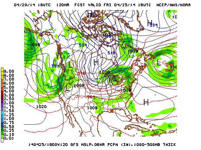
These lower totals are more in line with what would climatologically be expected this time of year. Still, it will be interesting to see how the the upcoming pattern change evolves in the coming days. Also worth noting is that–as is the case with most systems this time of year–there will be a risk of thunderstorms (especially over the Central Valley and Sierra Nevada foothills), first with the Tuesday system and then perhaps a more widespread risk of convection associated with the Friday/Saturday system. Regardless of the precise pattern evolution over the next two weeks: any rain (and late-season snow), while much-welcomed, won’t substantially change the extremely dry conditions now essentially locked in until next winter.
El Niño conditions increasingly likely by mid-summer
The developing El Niño conditions in tropical Pacific Ocean have received an increasing amount of media attention over the past several weeks. A number of recent headlines have used a rather eye-catching list of superlatives to this describe this impending event, detailing the risk of a “Super/Mega/Monster/Massive” El Niño in the coming months. Since there’s a lot of misinformation out there regarding the current state of the Pacific Ocean and the potential impacts of a strong El Niño event in California, I present a quick overview of these topics below. In the coming weeks and months, I’ll expand on these as more information becomes available and projections for next winter solidify.
- Is a “super El Niño” on the way?
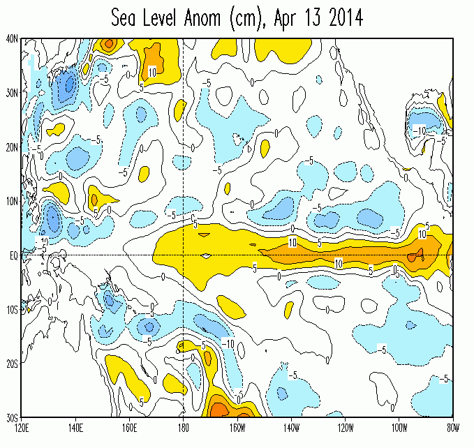
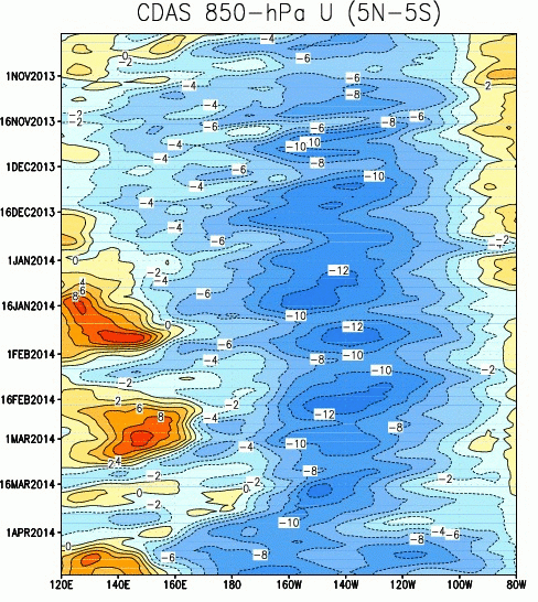
We know that the Pacific Ocean shows certain signs that El Niño conditions may be developing well before a full-blown event is actually underway. Current observations indicate that a number of these signs are becoming apparent, including the development of a very strong equatorial Kelvin wave, which appears to be the strongest since the one that immediately preceded the powerful 1997-1998 El Niño event. Other key indicators are the increasing occurrence of westerly wind bursts in the West Pacific and weakening easterly trade winds across the rest of the Pacific basin, with a subsequent shift in the location of tropical convection (thunderstorm activity) away from its climatologically-favored maximum. Sea surface temperature anomalies are not yet large, but have now trended positive across most of the equatorial Pacific. Thus, the most recent observational evidence does point toward the development of an El Niño event, with at least the potential for a strong event given the magnitude of subsurface heat anomalies.
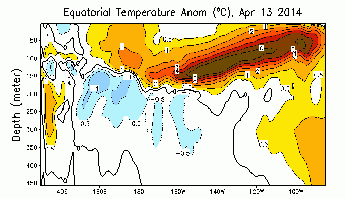
Another tool we can use in assessing the likelihood of an El Niño event this year is the operational ocean/atmosphere numerical models run by various meteorological agencies around the world. Right now, nearly all of the dynamical models (those models which explicitly include physical processes, rather than empirical relationships based upon observed historical conditions) project the development of El Niño conditions by fall 2014. Many of these models are projecting that sea surface temperature anomalies could exceed 1.5 degrees C in the Niño 3.4 region of the Eastern Pacific, which would qualify as a strong El Niño event. Thus, the fact that both observations and numerical models both support the imminent development of El Niño conditions, combined with the very large heat content anomalies both observed and projected, suggest that we will very likely experience El Niño conditions in 2014-2015 and that there’s a much above average chance that this event could be fairly powerful. It’s still too early to assert that we’re headed for a “Super El Niño” this year, but there’s a pretty respectable chance we’re headed for at least a strong one.
- Does El Niño always bring extreme precipitation and flooding to California? Will El Niño end the California drought?
Cool-season (winter) precipitation in the Southwestern United States is observed to vary semi-predictably with the state of the eastern tropical Pacific. When the Pacific Decadal Oscillation and ENSO are “in phase” (i.e. +PDO & El Niño or -PDO & La Niña), the relationship between ENSO and precipitation is much stronger, with El Niño events bringing above-normal precipitation and La Niña events below-normal precipitation. However, when the PDO and ENSO are out-of-phase, ENSO no longer has a highly predictable impact on precipitation, particularly in California. There’s more to the story than that, however. Strong El Niño events–particularly strong “East Pacific” events, like 1982-1983 and 1997-1998, where the ocean warming is concentrated in the easternmost part of the Pacific basin–have nearly always brought above-normal precipitation to California and have typically been associated with extreme precipitation/flood events. It’s still too early to know whether this event will be an East Pacific-centered event, even if it’s strong. There are some indications, though–namely, the continued eastward propagation of very large subsurface ocean temperature anomalies and the spatial structure of projected SST anomalies in the numerical models–that the impending event could well be a East Pacific event, rather than a Central Pacific event.
- When will we know more?
The oft-mentioned “Spring Predictability Barrier”–a term which describes the lower confidence atmospheric scientists have in numerical model projections for ENSO prior to the early summer months–significantly limits the specificity of forecasts that can be made prior to June. This is largely because the development of an El Niño event–even in the presence of very favorable oceanic conditions–requires that the overlying atmosphere become coupled to the ocean state such that the ongoing evolution of each becomes self-reinforcing (i.e. positive feedbacks develop between the ocean and atmosphere).
A non-trivial part of this “coupling” process involves stochastic (random) processes in the atmosphere, and for this reason until the developing event reaches a certain level of maturity later this summer there will remain a small chance that these highly-promising conditions could fall apart. While that appears to be the least likely outcome at this point, we probably won’t see high-confidence forecasts for the development of a strong El Niño event until perhaps mid-June. Until then, all eyes will remain on the tropical Pacific Ocean.
Administrative update: new site design
As you have probably noticed, the California Weather Blog now has a new look. All previous site functionality remains (and a few new things have been added), and hopefully the new layout makes for a simpler and more pleasant navigational experience. If you have any comments or complaints regarding the new site design, feel free to let me know in the comments thread on this post or via the contact form.
And on a final note: remember to follow Weather West on Twitter and Facebook for more frequent updates on California weather and climate! The Twitter account, in particular, is updated more frequently during periods of active weather (if you’re not a member, the post feed is also available in the right sidebar of the new Weather West site).
Thanks for reading!
© 2014 Weather West
Discover more from Weather West
Subscribe to get the latest posts sent to your email.