Extremely wet October in NorCal, then an extremely dry November…and a severe Western “snow drought”

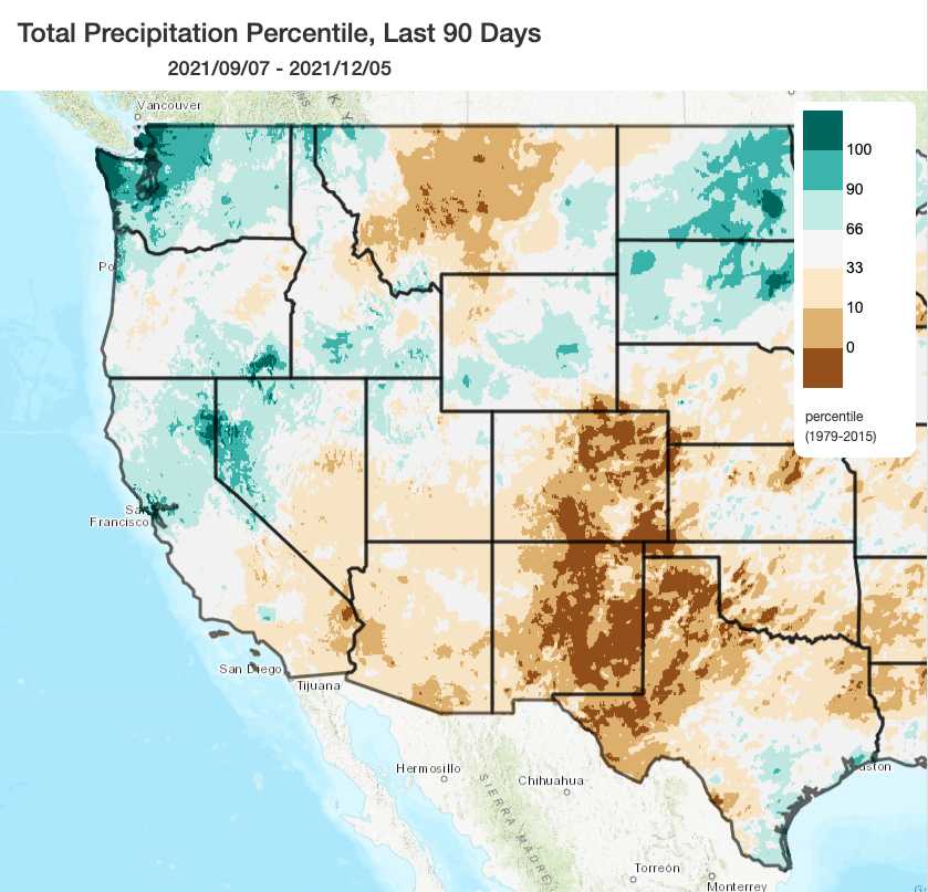
It has been a pretty interesting autumn, weather-wise, across much of North America. Record precipitation and severe flooding were observed in the Pacific Northwest and British Columbia; meanwhile, record warmth and dryness occurred across much of the interior West and Great Plains. In California, autumn 2021 proved to be a major departure from recent years, as a record-breaking atmospheric river event in October doused much of the northern half of state with extremely heavy rainfall that accounted for more than the entire average precipitation for the entire autumn season in just 2 days. Aside from that October event, though, precipitation has been very low statewide and temperatures have generally been well above average (except for some Central Valley folks stuck under a persistent layer of tule fog most days).
The net effect of all of this: California saw pretty minimal autumn wildfire activity due to relatively high soil and vegetation dampness and a lack of strong offshore wind events. NorCal saw some modest/partial drought relief, although precipitation deficits have further risen in SoCal. Accumulated precipitation from September 1 remains somewhat above average across much of NorCal (thanks to the big Oct. AR), but near or below average elsewhere following a long, multi-week dry spell during most of November into early December.
In a broader sense, the entire American West is presently experiencing a severe “snow drought” due to extremely warm (and, in many cases, also extremely dry) conditions this autumn. Snow water equivalent is well below average in every single major watershed from the Rocky Mountain Front Range to the Pacific Coast–a pretty extraordinary statistic. Interestingly, that includes PacNW watersheds that have actually received a lot of water this autumn–a product of warm atmospheric rivers that produced a lot of rain but very little snow due to high freezing levels. I do expect substantial improvement in this map along the Pacific Coast states over the next 2 weeks (including the Cascades and Sierra Nevada), although less so across the interior West.
Needed and welcomed precipitation on the (near-term) horizon
The good news is that there is a high likelihood of a major pattern change that will bring widespread rain (and mountain snow) to California over the next 10-14 days. A weak system moved in late Monday, bringing some local showers, but that’s likely to be just the appetizer. A second relatively weak system will move through CA on Thursday, bringing some more patchy light precipitation (which may actually skip much of NorCal, but bring some more substantial precip to parts of SoCal). But the real activity is slated to begin about 5-7 days from now, when a short series of cold and slow-moving storms may bring much more substantial rain and snow to the entire state.
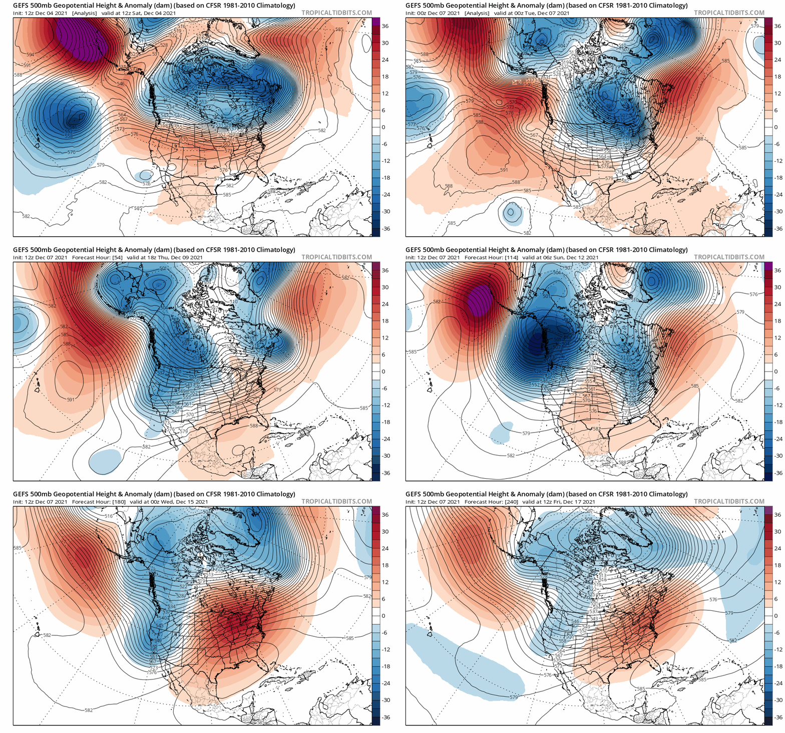
At macro-scale, this pattern shift will be brought about by a retrogression (westward movement) of the persistent ridge axis near the West Coast to a position in the Gulf of Alaska. This will allow meridional flow and cold air to take up residence near the West Coast, allowing for a series of storms to affect California in the medium term. Right now, these look likely relatively cold (though not extremely so) systems that could be big Sierra snow producers and could, perhaps, allow for some foothill accumulations as well above 2,500-3,000 feet. It’s pretty likely that precipitation will be widespread across California, including the southern third of the state where rain and snow are much-needed following another dry autumn.

Storms should help bolster very low snowpack and restore some streamflow
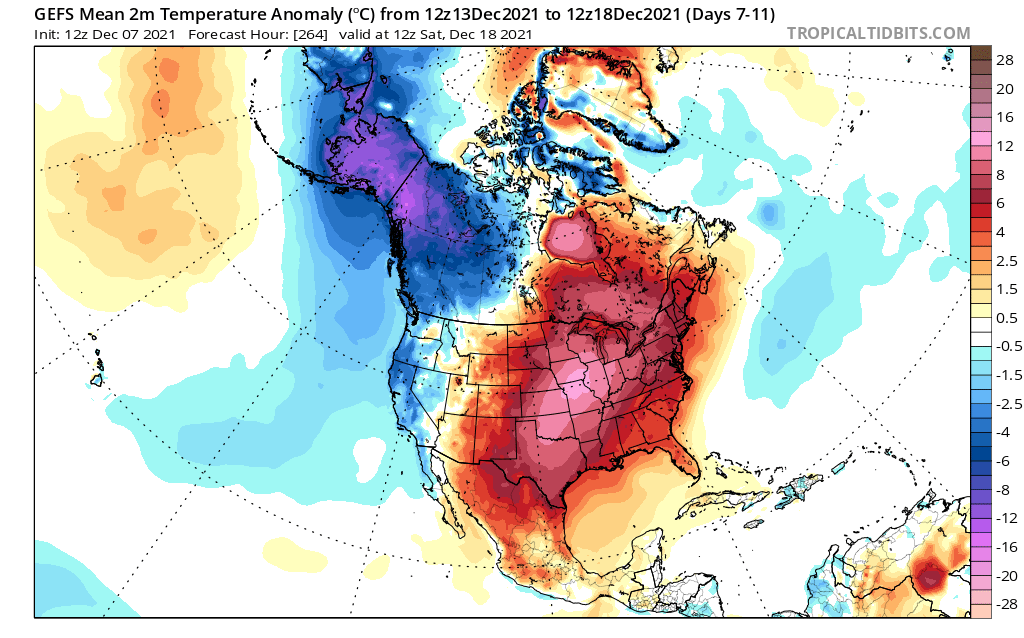
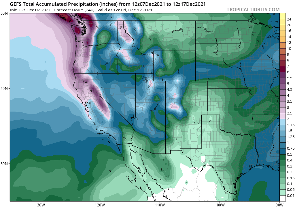
I am pretty optimistic that this pattern change, even if it ends up being relatively short-lived (as ensembles are hinting), could nevertheless greatly bolster Sierra snowpack over the course of just 7-10 days. 2-3+ feet of snow at Sierra pass level is possible over the next 10-14 days, and I would expect substantial (though lesser) accumulations at lower elevations as well. Widespread moderate to locally heavy precipitation is also plausible at lower elevations, hopefully raising streamflows and re-saturating the soils that have dried out since the big October AR.

Conditions will also be much cooler than they have been recently, although there are not presently strong indications of any kind of extreme cold (just modestly below average temperatures for 7-10 days). That is in great contrast with the extremely warm and likely record-breaking winter heatwave that is likely to develop over the Central U.S. during this same period–a product of upstream blocking that will help ensure that the California cold storms stick around long enough to deliver some substantial rain and snow.

At the moment, multi-model ensemble averages are depicting substantial and welcomed precipitation accumulations over the next 10-12 days, but nothing extraordinary (the ECMWF ensemble suggests that total precipitation over the next 2 weeks will be around 100-110% of average for most of California). But there are a few individual ensemble members that are depicting much more extreme precipitation totals (leading to widespread 4-6+ inch precip totals in NorCal and upward of 4 feet of Sierra snow accumulation). The key seems to be that these members tap into a subtropical moisture plume and produce a strong & slow-moving atmospheric river, while most others do not. Those members, including some recent operational runs, remain outliers–so while the probability of a very strong storm/very heavy snow accumulations is not zero, it remains an unlikely outcome at this point. Nonetheless, in a pattern characterized by highly meridional flow and both upstream and downstream blocking, there can sometimes be failures of even large ensembles to capture the dynamics correctly. So I will definitely be keeping an eye on the potential for this pattern change to be upgraded from “mostly beneficial/near-average precipitation over the next 2 weeks” to something greater. All in all, though, the most likely outcome is a well-timed “old school” cold storm sequence right before the end of the calendar year.
And now for…something I think is cool
You may have seen some images floating around the web generated using the new artificial intelligence-based synthetic art tool floating around (via wombo.art). It turns out that the visual representations of some of the more evocative atmospheric science terms in “AI dreamworld” are actually…quite cool. If you’re interested, check out my brief thread of images below…or try it out yourself!
Discover more from Weather West
Subscribe to get the latest posts sent to your email.