What a difference a week makes!

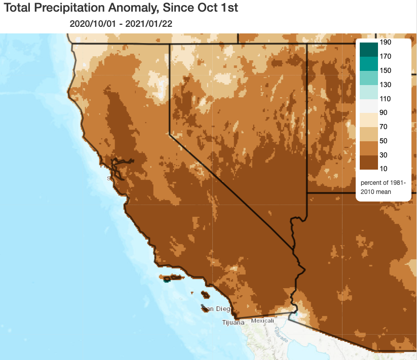
The first half of January didn’t feel much like winter across California. Much of the state experienced record high temperatures–in some places, up into the 80s and even 90s (across SoCal). Snowpack has now dropped to 40% of average for the date. Combined with the near-record dry start to the wet season, vegetation moisture levels dropped to a level that supported a surge in rare mid-winter wildfire activity–even across typically very wet parts of NorCal. This record warm and dry period was immediately followed by one of the more remarkable state-wide, mid-winter offshore wind events in recent memory. This wind event caused quite a bit of wind damage and ignited numerous fires on the Sierra Nevada western slopes and across other parts of central/southern California–Yosemite remains closed, as well as several other nearby parks, due to extensive damage caused by large falling trees.
Then, merely a week later, the still-smoldering winter wildfires in the Santa Cruz Mountains were dusted by snow as low as 2,000 feet elevation. Additional light snowfall will be possible over the next 36 hours as another cold/unstable system sweeps down the coast.
Very strong, cold storm to arrive by Tuesday evening across NorCal

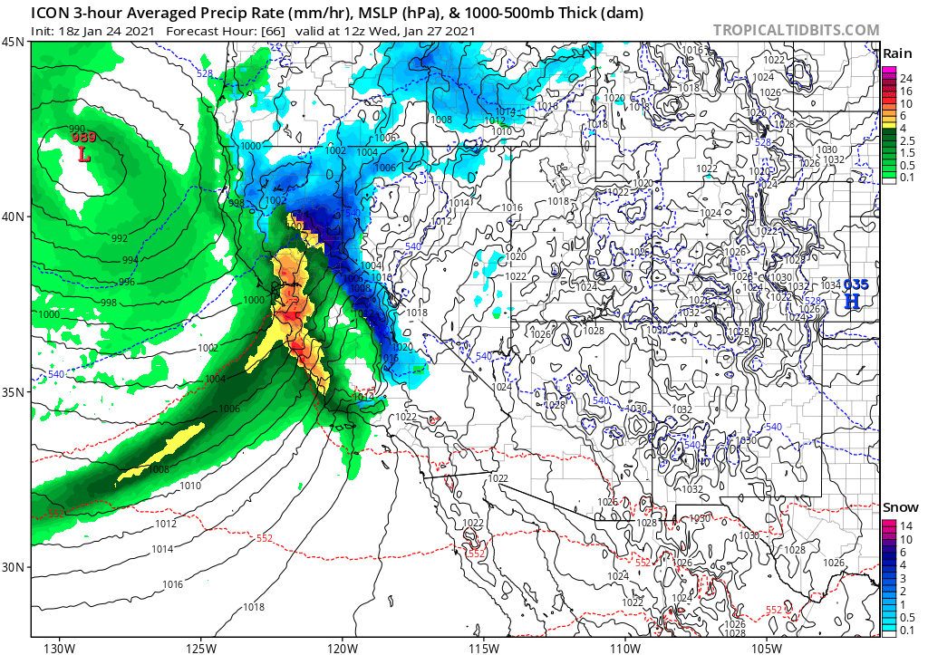
Well, get ready for another pretty dramatic change in the weather statewide this week. Another weak but cold storm Monday will bring widespread showers and isolated thunderstorms, with snow levels locally as low as 2,000 feet. But the main event is still slated for mid-week–from late Tuesday into Thursday. A very strong, cold storm system will drop southeastward toward California on Tuesday. As a surface low deepens well north of California, a powerful cold front will strengthen quickly as it progresses southward from the North Coast toward the San Francisco Bay Area. Given a favorable upper jet structure and a pre-existing cold airmass, this system will have some pretty impressive dynamics to work with–and will feature a much sharper surface temperature differential than is common in California winter storms.
As the strengthening cold front moves across the SF Bay Area, it will begin to tap a pool of subtropical moisture moving up from the southwest, forming a moderate-strength atmospheric river. But this storm is likely to be stronger than the “moderate” classification of the AR might suggest due to the very favorable dynamics mentioned above–which will lead to strong upward vertical motion along the cold front and the potential for very high rainfall rates, strong wind gusts, and maybe even some embedded lightning.
Thus, most folks north of Monterey can expect a pretty dramatic storm overnight Tuesday into Wednesday, with a multi-hour period of heavy precipitation and strong winds. Because this AR will coincide with strong atmospheric dynamics, I would expect significantly less rain shadowing than usual in valleys and lee-side areas that are often shielded by topography–meaning that even lower elevation urban areas should see heavy precipitation as well as the coastal hills/western slopes.
Winds may be pretty notable with this system as well–I would expect pretty widespread gusts of 50-60 mph across almost all of NorCal and parts of coastal SoCal, including some usually wind-sheltered areas as heavy precipitation mixes gusts to the surface. This is high enough to cause power outages and downed trees. Even higher gusts may be possible along the coast and near Monterey, which is currently shaping up to be the “bullseye” for wind maxima in this event.
Massive Sierra Nevada snowfall, and also some Sac Valley low elevation accumulation?

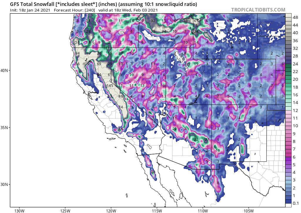
This multi-day event is going to bring enormous Sierra Nevada snow accumulations–certainly on the order of feet, and perhaps many feet. I would not be surprised to see a few reports of snowfall exceeding 100 inches (8 feet!) at the snowiest spots in the high Sierra over the next 7 days or so. Snow levels will be pretty low throughout this event (never really rising much above 4,000 feet), but will start out very low indeed for such as strong storm (perhaps 2,000 feet, or locally even lower).
In fact, there are signs that the precipitation across the far northern Sacramento Valley could start out as heavy, wet snow Tuesday evening before changing over to rain later at night. It’s very unclear at this point whether significant snow accumulations will occur in places like Redding and Red Bluff, but it appears possible. “Flakes in air” are possible even south of that, perhaps down to the central Sac Valley, but accumulations are exceedingly unlikely that far south. There has been some buzz regarding the potential for a major Redding/Red Bluff snowstorm, and while I don’t think that’s the likeliest outcome, it does appear there is at least a small chance of this happening.
Over the Sierra Nevada, where long-duration heavy snowfall is a sure bet, travel disruptions will be extreme. It will likely be impossible to travel on I-80 between Reno and Sacramento for a portion of this week, possibly for several days, so plan accordingly. The good news is that current snowpack is abysmally low, so these huge accumulations will offer a major boost to California’s snowpack water storage.
Atmospheric river will bring flash flood/debris flow, especially near SF Bay-Central Coast burn scars
This pattern change has a good chance to be a net beneficial snowpack and water supply booster–with the major, glaring exception of the risk it poses near recent wildfire burn scars. The record-setting 2020 wildfire season burned around 4.5 million acres in California. Of that total area burned, certain subsets are highly vulnerable to post-fire debris flows and flash flood events. Generally, the highest risk is in portions of these burn scars where fires burned at a particularly high intensity and created “hydrophobic” soil conditions, and/or in places of particularly steep topography subject to rapid erosion during heavy rainfall.
During the Wednesday/Thursday cold frontal passage, it is more likely than not that hourly rainfall rates will exceed thresholds capable of triggering significant debris flows over portions of the LNU Complex, CZU Complex, SCU Complex, and Dolan Fire burn scars from 2020. The highest risks to people may be in/near the LNU/CZU scars due to proximity to populated areas, but the highest meteorological risk may actually be in Monterey County.
This is because the front and associated AR is expected to stall somewhere along the Monterey/SLO County coast on Wednesday before lifting slightly back *northward* by Wednesday night as a mesoscale frontal wave develops. It’s still not 100% clear exactly where this stall will occur, but I would expect a swath of widespread 5-10 inch rainfall where this occurs (and locally 15 inches or more in orographically favored parts of the stall zone). Some flooding could occur even outside of wildfire risk zones around the location of this stall. Right now, Monterey County looks like the most likely bullseye for this–but it could happen as far north as Santa Cruz County. Even absent a stall, rain rates across the Santa Cruz Mountain burn scar will be concerning–but if the AR does find its way back north for a second pass, local concerns will be further exacerbated.
Eventually, this whole system will once again start progressing southward/eastward. Moderate to heavy rain and some strong winds are then likely across most of SoCal as the system moves across the regions. Impacts are likely to be somewhat less than across NorCal, but there is still some level of concern regarding debris flows across the 2020 burn scars.
More active weather to follow: cold/wet pattern for at least ~10 days

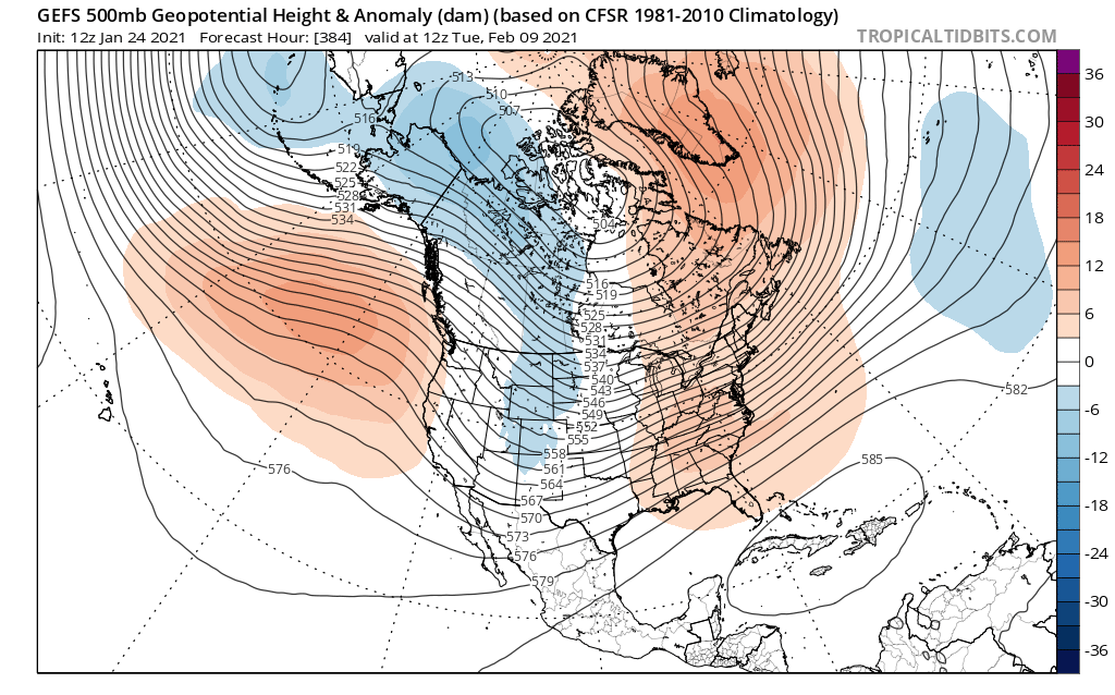
This does not appear to be a “one and done” storm system. Instead, multi-model ensembles are in pretty good agreement that there will be at least 1-2 additional cold systems that will affect the state during this cold/wet pattern shift. These follow-on storms will be weaker than the mid-week storm, but could still produce substantial Sierra Nevada snowfall and may add as much as a few additional feet of snowpack-bolstering high elevation accumulation. There are currently hints that a dry pattern could return by the end of the first week in February, but for now let’s focus on the large amount of rain and snow to come over the next 7-10 days. Enjoy the storms this week–and stay safe out there! This precipitation will be very beneficial for much of the state–hopefully, we can manage to avoid any major debris flows/flash flood events this week in the fire scar zones.
Discover more from Weather West
Subscribe to get the latest posts sent to your email.