A bone-dry February compounds dry start to winter

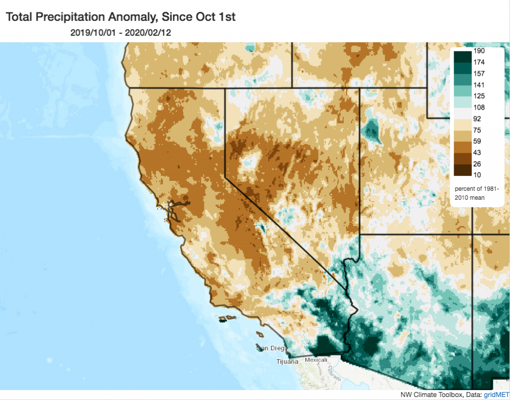
Autumn 2019 was record dry across parts of northern California. Despite an early December reprieve (especially in southern California), conditions have increasingly become increasingly dry across most of the state since that time. Parts of California have now gone 3-4 consecutive weeks without any meaningful precipitation during what is typically the wettest month of the year. As a result, increasingly wide swaths of the state have fallen well below typical seasonal precipitation accumulations–many locations in the northern half of the state are running below 50% of the Oct 1-Feb 12 average. Recent record warmth in some areas has compounded this dryness, further reducing Sierra Nevada snowpack and even allowing regional vegetation to support a (low) level of potential wildfire activity.
Next 2 weeks look very dry (still)
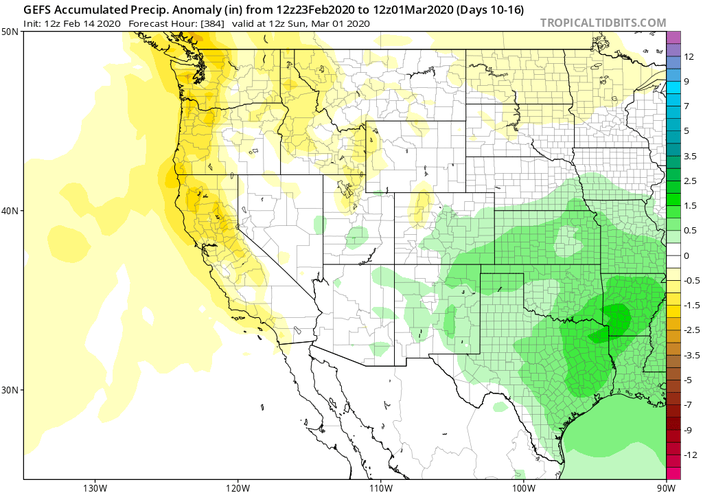
Unfortunately, there’s very little (if any) relief on the horizon over the next 10+ days. The next 7 days may feature completely dry conditions across 85% or more of California; the following week may feature a chance of showers in some spots, but will very likely be mostly dry in most places. That will bring us to the end of February without any widespread significant precipitation–meaning that existing precipitation and snowpack deficits will continue to grow.
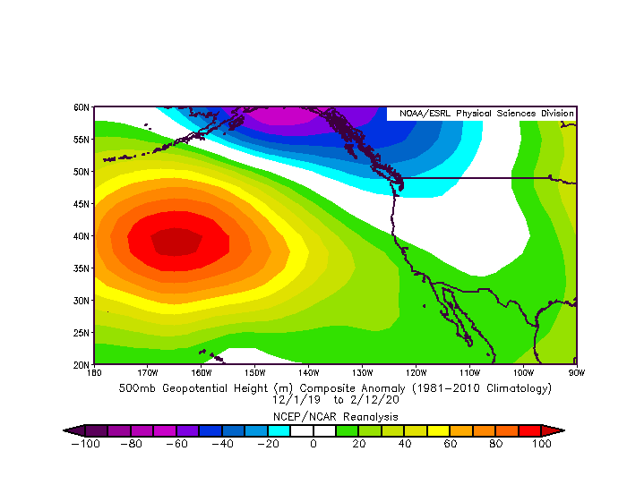
What’s going on over the Pacific Ocean? (Regular readers will already have a sense of where this is going). Well, a persistent ridge of high pressure has been holding relatively steady over the far northeastern Pacific over the past 5-6 weeks, and is expected to persist for at least 1-2 more. The mean ridge axis has been shifting slowly eastward over the past couple of months, but still hasn’t quite made it all the way to the West Coast. As noted in the previous blog post, this particular ridge position is favorable for dry (but not completely so) and generally cool conditions. While such a ridge effectively blocks the primary Pacific storm track, it does allow cold/dry systems to drop southward from Canada and bring mostly cold temperatures and wind to California, outside of occasional scattered mountain and southern California showers. Until there is a major pattern shift, this same kind of recurring pattern can be expected to continue for the foreseeable future.

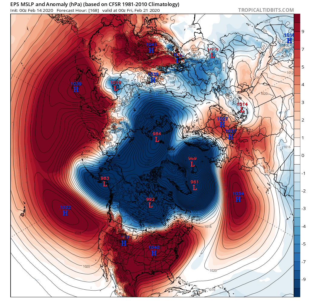
Right now, there are perhaps modest signs that the prevailing ridge could weaken in early March, though there are no clear signs of impending breakdown. Interestingly, California is not alone in its high pressure plight at the moment–nearly all of the Northern Hemisphere mid-latitudes are experiencing similarly “ridgey” conditions right now. Much of this can be blamed on the presently record-strength positive phase of the Arctic Oscillation. This essentially means that (in great contrast to recent years) both the stratospheric and tropospheric polar vortex are exceptionally strong at the moment, which is keeping Arctic air locked up tightly in the high latitudes. One consequence of this record-strength AO is a broad displacement of atmospheric mass from the Arctic to the mid-latitudes (in other words, unusually low pressure in the Arctic and unusually high pressure essentially everywhere else). The ECMWF model suggests that the AO may go even higher over the next 7 days–shattering the previous record (set just last week) by an even wider margin.

Has the Ridiculously Resilient Ridge returned?
Understandably, I’ve started to see this question floating around with increased frequency in recent days. Drought anxieties are running high, given such recent experience with the worst drought in California history (during 2013-2016).
My answer, right now, is that we’re not quite there yet–but we’re getting closer. Multi-week dry spells are neither that unusual nor particularly worrying in California–mid-winter lulls are just part of the intrinsic climate here. But now that we’re seeing multi-month persistence of high pressure and far below average precipitation, the story’s starting to change a bit. At this point, it’s exceptionally unlikely (given the current forecast, and historical precipitation climatology for the rest of the season) that we’ll be able to erase the accumulated precipitation deficit by the end of the rainy season–so it is virtually certain (even with a “Miracle March”) that we’ll end up drier than average this year. But if we do see a wet spring, some of those impacts will be temporarily mitigated.

Presently, storage in California’s surface water reservoirs is sufficient to carry the state over until the next wet season even if the precipitation spigot were to completely shut off as of today (which is unlikely). That should ease drought concerns for urban and agricultural areas, at least for this year. On the other hand, the natural landscape does not benefit from water stored in man-made reservoirs–so if the rains don’t pick up soon California will start seeing significant impacts to ecosystems, and therefore vegetation and subsequent wildfire risk this summer and coming autumn. It’s still too early to discuss those potential impacts in detail, since much will hinge on March and April. Stay tuned.
New research on atmospheric rivers!
For the presently precipitation-starved: you might be interested in checking our recently published research on improving atmospheric model simulations of extreme atmospheric rivers. Some of you might be able to pick out your favorite California (or West Coast) storms from the past ~4 decades from the lineup! Ultimately, this work forms the basis of additional research focused on how the most intense winter storms in California will change in a warming climate. (That paper is still currently in revision–I’ll be sure to write a full blog post on that one when it becomes available). For now, check out the public Twitter thread below or visit the journal website directly: shorturl.at/CJZ47
Discover more from Weather West
Subscribe to get the latest posts sent to your email.