A dry autumn to date in most of California! But hydroclimate whiplash to come…
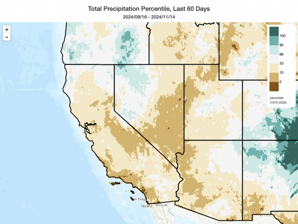
It did turn out to be a much drier than average autumn across most of California and the Southwest after all (except the northernmost part of the state). Well, that has been true through mid-November, at least–though it’s going to change dramatically later this week. (Perhaps there’s a kernel in there about the wisdom of using canonical 3-month seasons to define meteorological seasons in California…but that’s a conversation for another day!)
Notably, the second most destructive wildfire of the year (from a structure loss perspective)–the 20,000 acre Mountain Fire in Ventura County, which destroyed around 250 structures–occurred during the major Santa Ana wind event discussed in the last blog post. The 2024 California fire season was ultimately quite a destructive one overall by historical standards, with four separate fires burning over 100 structures each and around 1,700 destroyed overall (a little over 1 million acres burned in total–well above the contemporary historical average). This very active fire season was facilitated by a one-two punch of extremely wet conditions during 2023 (and 2024 in some locations, especially central and southern CA coastal regions) yielding abundant vegetation growth, followed record-breaking heatwaves periodically during summer and autumn drying vegetation at lower elevations out to near or exceeding record levels during periods of elevated fire weather conditions.
It’s now looking like 2024 will feature yet another autumn-to-winter transition featuring a rather dramatic period of “hydroclimate whiplash”–a rapid swing from anomalously dry to anomalously wet conditions–across much of CA and other portions of the West. Is it true that California’s seasonal transitions, especially in autumn, are often characterized by rapid transitions? Sure! But in this case, I’m talking about swings from dry to wet that are especially large in magnitude, or suddenness, relative to the already elevated norms in this part of the world–and which are anticipated to become even sharper in a warming world. If you find this interesting, I’ll have much more to say on the topic in early 2025 when a major publication we’ve been working on for 3 years is finally published!
Strong, moist, and very slow-moving atmospheric river headed for NorCal/southern Oregon
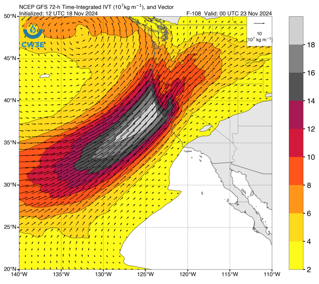
The upcoming atmospheric river event will be a very long duration event for portions of Northern California north of the SF Bay Area. It will also be strong, with rather high instantaneous integrated vapor transport (IVT) levels at multiple time points. This combination of “long duration” and “strong intensity” will yield an overall rain event that will be, in many ways, more impressive than the sum of its parts. Right now, this event appears to be a solid “AR-Cat 4” (out of 5) event, but given its duration it might end up being closer to a Cat 5 event in some locations. That’s a pretty big deal. The above plot shows three day accumulated IVT (i.e., this is not a snapshot of the AR at any single point in time, but rather a measure of the accumulated atmospheric water vapor fluxes over the most intense 3 days of the event). These are extremely high accumulated IVT values between about Sonoma County and Del Norte County, and this is where the most notable very heavy to extreme rainfall is likely to occur (especially on orographically favored slopes). As discussed below, this AR will stall over NorCal for at least 2-3 days and bring successive waves of renewed heavy precipitation as various frontal waves and mesoscale features cause the “firehose” to flail up and down the coast.
This system will also develop, in its later phases, a pretty robust subtropical moisture tap extending to just north of Hawaii–so this event will become even warmer as the storm drags on and could entrain quite moist air amid persistent onshore flow into CA. This also has the signature of an event (again, see further discussion below) that may persist for somewhat longer than currently indicated, and therefore could have somewhat greater rain/flood impacts than the current median outcome suggests.
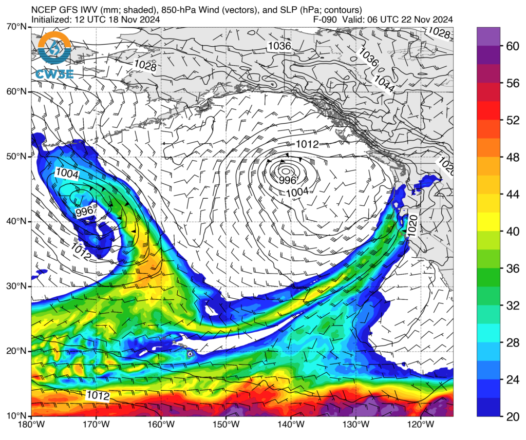
Yes, there will be a “bomb cyclone” in the northeastern Pacific again…and it’ll be a doozy.
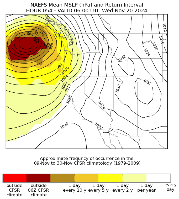
Is “bomb cyclone” a real scientific term? Yes. Will there actually be a bomb cyclone off the West Coast this week? Yes–most definitely! A bomb cyclone simply refers to a low pressure system that deepens very rapidly; the quantitative definition varies by latitude, but at a latitude of ~Portland, OR is approximately 18-20mb or hPa per 24 hour period. This particular system will blow right past that–deepening by 60-70mb in a 24-36 hour period! In fact, this will likely be among the fastest if not the singularly fastest-deepening low pressure system on record in this region. And with an estimated minimum central pressure near 940mb (maybe even a bit below that!), this will also likely become among the most intense low pressure systems on record in this region.
Science communication advice and meteorological tangent: I have no issue calling this a “bomb cyclone” as it will undoubtedly undergo the process of “bombogenesis” (i.e., exceeding the “deepening per 24 hr” benchmark above. It’s going to be a textbook example of such a storm! But it is also important to convey that just because a storm qualifies as a “bomb cyclone” does not necessarily mean it will have any particular level of impacts. This will be a major storm for the West Coast, but not nearly as severe of an event had the low pressure center been closer to the coast when it “bombed out” (see next section). Also, I do think it’s misleading to compare possible 940mb minimum central pressure readings to a “Category 4 hurricane.” Although these minimum pressures may technically be similar, this storm will not be a tropical cyclone, and will not bring wind speeds (even over the open ocean) nearly as strong as a Category 4 hurricane (which, definitionally, have sustained winds of 130-156 mph!). The main reasons for this difference? The maximum pressure gradients in a mid-latitude cyclone (like this one) are much weaker than in a tropical cyclone (like a hurricane), and also they tend to lack the kind of vigorous eyewall convection that can mix extremely strong winds aloft to the surface.
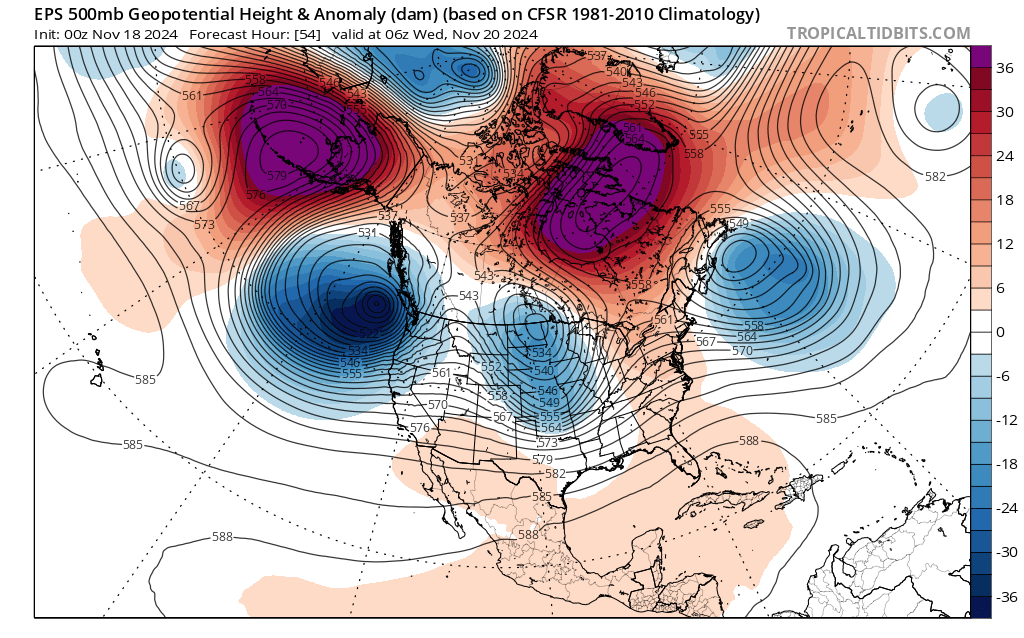
Dynamically speaking, the upcoming pattern is a rather classic one for a warm/wet AR setup in OR/CA: strong and persistent atmospheric blocking in the sub-Arctic (two lobes, one over the Aleutian Islands and the over west of Greenland) will lead to a highly meridional (latitudinally-oriented) jet stream orientation and thereby generate strong baroclinic instability downstream (most dramatically in this case yielding a “bomb cyclone” west of Oregon). This pattern, notably, does not feature an especially strong Pacific jet stream over most of the basin–but instead results from a relatively regionalized zone of strong horizontal temperature contrasts and the subsequent development of a very strong storm system/regional flow pattern that favors very active West Coast weather. This pattern is also a fairly persistent one, so I would not be too surprised if the period of active weather sticks around a bit longer than is currently indicated.
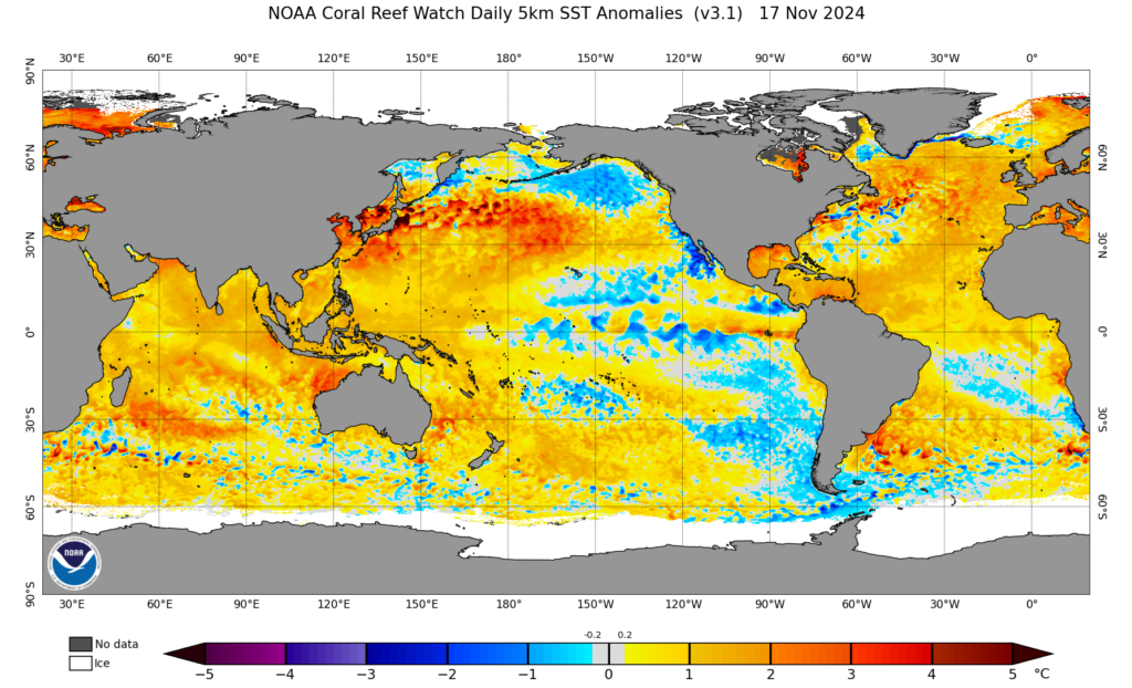
It is also worth noting that global oceans remain exceptionally to record warm in many regions. In fact, one of the largest and most anomalous warm areas of the global ocean surface is along the exact trajectory this week’s atmospheric river will take from the central North Pacific just north of Hawaii east and northeastward toward northern California. Although SSTs along the immediate CA coast are actually a bit cooler than average at the moment, it’s likely that this long overwater trajectory over water ~2-4+F warmer than average will add some extra “juice” (i.e., lower tropospheric moisture) to the inbound AR and perhaps make it a degree or two warmer than it would have been otherwise. It is also, arguably, a potential contributor to the potential magnitude of rapid strengthening of the parent low pressure system (as warmer oceans to the south of the storm formation region can yield stronger thermal contrasts with colder air masses moving in from the north, and also facilitate greater latent heat release from increased condensation in the developing storm).
Flood, wind, and wave impacts: Where, when, and to what degree?
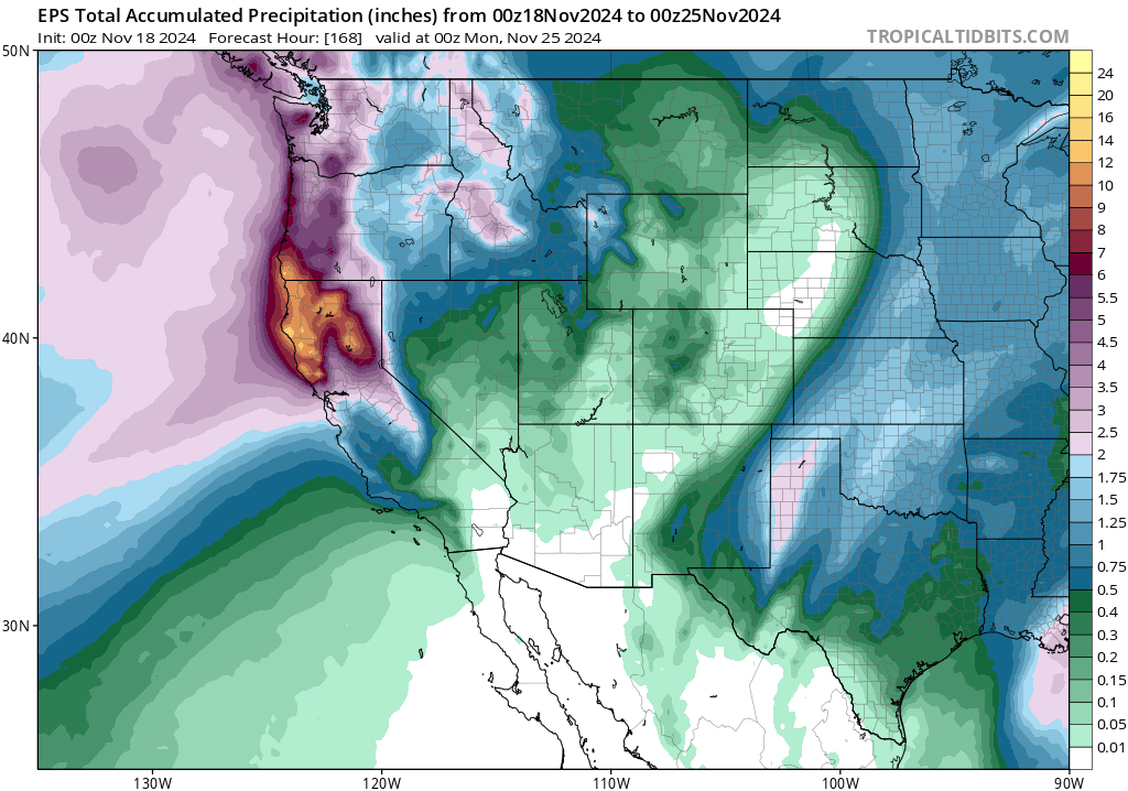
There is always uncertainty regarding the exact locations that will experience the heaviest rainfall from slow-moving atmospheric river setups that involve one or more frontal waves, as the upcoming event undoubtedly will. With each such wave, and there may be as many as 3 with this event, the axis of the AR can wiggle up (northward) or down (southward) along the coast like a flailing firehose–returning to areas previously deluged earlier in the event. Given the near-guarantee at this point that the strong and warm AR will stall out somewhere over NorCal later this week, with multiple frontal waves causing some flailing, we still don’t know where the axis of maximum rainfall will occur. It has already shifted southward from southern Oregon to far NorCal, and could shift again either back northward slightly or farther southward (and thereby encompass more of the Interstate 80/SF Bay Area corridor). What is clear is that much of NorCal from about Sonoma County northward will see a prolonged period (3-4+ days, depending on how things play out) of sustained moderate to heavy rainfall. Widespread rainfall accumulations along the North Coast (and extending eastward to the Shasta/northern mountains and southward to Mendocino/northern Sonoma) of 8-15 inches are likely; the wettest spots may end up above 20 inches over a 5-7 day period (likely orographically favored peaks). This is more than enough rainfall to cause widespread urban and small stream flooding, and likely also some river flooding. It’s too early to know whether river flooding up north will be of the minor to moderate variety (it does help that this is the first widespread rain event of the season, and soils are not yet completely saturated nor river levels running high…yet) or more significant. If the AR does truly stall out for a fully 3-4 days over the same area, it is plausible that more significant river flooding could occur (especially in far Norcal/far southern Oregon), but that remains TBD. Also of note is the high potential for flash flooding, rockslides, and perhaps debris flows in and near recent wildfire burn areas in far NorCal, especially the very large Park Fire footprint.
Farther south, there is much more uncertainty regarding how much rain will actually fall. There will likely be a sharp cutoff from north to south, perhaps somewhere near the central or southern SF Bay Area, separating the region of heavy rain from the region of merely light to moderate rain (at least during the initial stages of the event). If that line sneaks southward, the risk of some flooding could extend farther south toward SF Bay (though I do not think this is likely to be a significant flood event in this part of the state because rainfall is expected to be lower than further north and antecedent conditions are even drier.
SoCal, for its part, may stay mostly or entirely dry through the first half of this event as the strong/warm/moist AR remains stuck over NorCal for days. Heading into the weekend and early next week, there is even greater uncertainty and thus a winder range of potential weather outcomes. Some model runs have indicated a higher potential for a decent rain event to occur all the way south to LA/San Diego if the parent low pressure system can make enough south/eastward progress, perhaps dragging a continued atmospheric river of some strength along with it. It would probably be a pretty warm storm, if it occurs, and bring fewer impacts than up north. But it is something to keep an eye on, as this is a highly dynamic flow pattern and things can change pretty dramatically 5-7 days out under such conditions. Stay tuned!
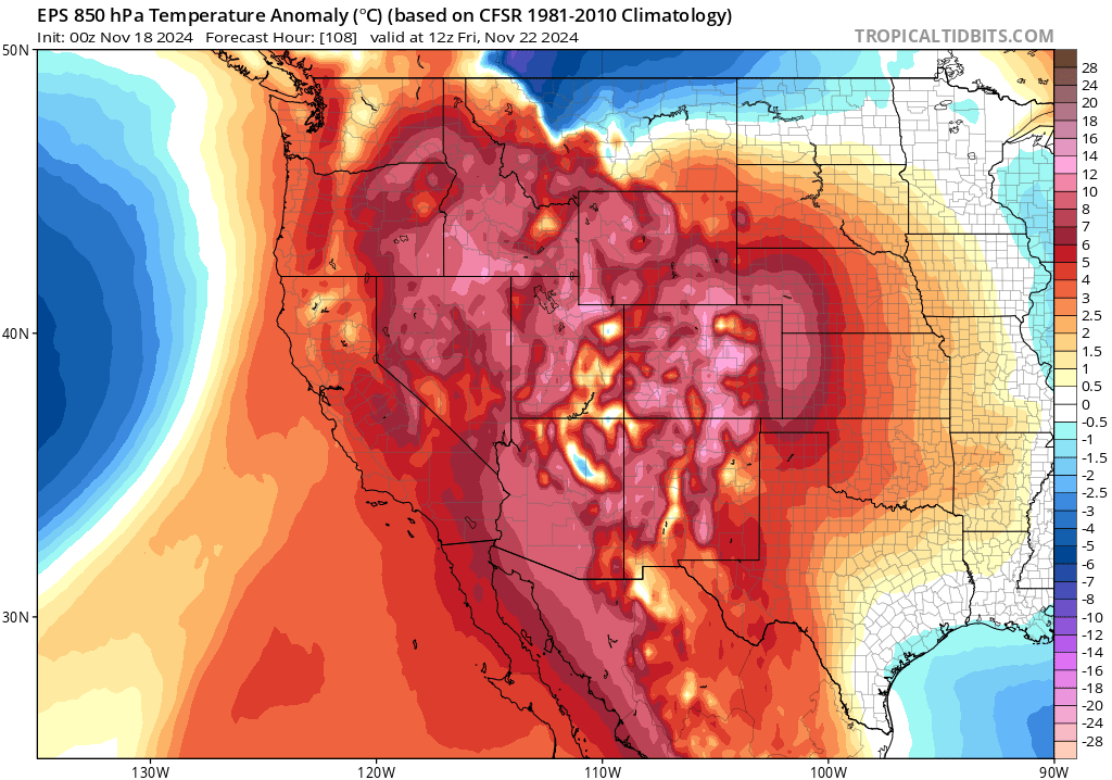
Also notable: this storm, and the weaker storm that will precede it this week, will start out with a fairly cold airmass in place; local snow accumulation is initially going to be possible down to 2,500-3,000 feet elevation in far NorCal and southern Oregon. As much warmer subtropical air overspreads the region amid very strong warm advection later in the event, snow levels will rise dramatically (but there may still be some pockets of trapped colder air near the surface in mountain valleys up north, yielding a brief period of heavier wet snow or even a bit of freezing rain). This does mean, though, that the vast majority of the precipitation from this prolonged AR event will fall as rain (rather than snow) nearly everywhere but the highest mountain regions. So don’t expect much net snow accumulation except for some “Sierra cement” above 8-9k feet (could be somewhat lower snow levels at the very back end of the event when a more substantial cold front finally moves through, but it won’t amount to much SWE). This is very much looking like a warm, very wet, rain event for the most part.
With a low pressure center possibly dropping to near (or even below!) ~940mb, there will be very strong winds well offshore of BC/OR/WA/NorCal. Fortunately, the strongest winds will likely remain offshore (this does not look like a worst-case wind event for the West Coast, despite the extremely low pressure, because the low pressure center will stay well offshore when it’s at peak strength). Still, though, sustained hurricane force (~74mph or greater) winds will occur over the open ocean and very strong/damaging wind gusts are still possible along the Oregon coast (80-90+ mph gusts possible) and the far NorCal coast (mainly North Coast, where I would not be surprised to see 70-80+ mph gusts). Ocean waves of 50-60 feet (!) are likely, and some might even even end up larger depending on exact storm trajectory. Winds of this magnitude will probably cause power outages and tree damage on land–but we are fortunate the explosive deepening of this low pressure system is not expected to occur closer to the coast or otherwise we’d potentially be talking about a windstorm of historic magnitude in these same places.
Farther south, it will be windy even into the SF Bay Area and central CA when the AR and cold front pass through–but I do not expect widespread damaging winds that far south at this time. Given the very strong dynamics at play, though, there’s a slight chance that the expected wind magnitudes/locations will shift still so it’s worth keeping an eye on.
There may also be a few opportunities for some thunderstorms with this storm sequence. I don’t think this storm will be as “electrified” as those we’ve seen the past two winters (those were associated with much colder air aloft, with greater ambient instability), but the strength of the offshore low and associated frontal lifting plus a relatively warm/moist airmass in the AR plume could still generate some lightning or embedded torrential downpours locally (more likely the farther north you go along the coast).
I’ll be on YouTube, live, at 2pm Tuesday Nov 19 to discuss (and then again at TBD time later this week)
The title says it all: I’ll be talking atmospheric rivers, bomb cyclones, and potential uncertainties/impacts at 2pm Pacific Time on Tuesday, November 19th. I’ll also be taking questions via the live chat, as always. I also plan to run another live session later this week closer to the peak of the event (date/time TBD, so stay tuned).
Discover more from Weather West
Subscribe to get the latest posts sent to your email.