A mercifully mild summer (with a couple of major exceptions!)
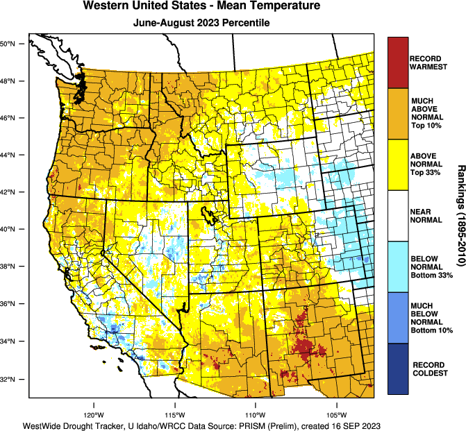
Well, Summer 2023 was a pretty remarkable one across California and the Western U.S.–but for rather different reasons than in recent seasons. Consistent with the long-term warming of the West, this summer was much warmer than the 20th century average in most places–especially in the Pacific Northwest and in Arizona/New Mexico. In California, conditions were actually cooler–close to the long-term average in many places, but also including regions of warmer than average in far NorCal and cooler than the long term average across portions of the coastal SoCal counties. It was not, however, record warm this summer anywhere in California–the first time that’s happened in a while, and a real testament to “shifting baseline syndrome:” a lot of folks felt this summer was pretty chilly in comparison to most of the past decade (which it was in a lot of highly populated parts of the state!), but in the longer term context this was not an especially cool summer.
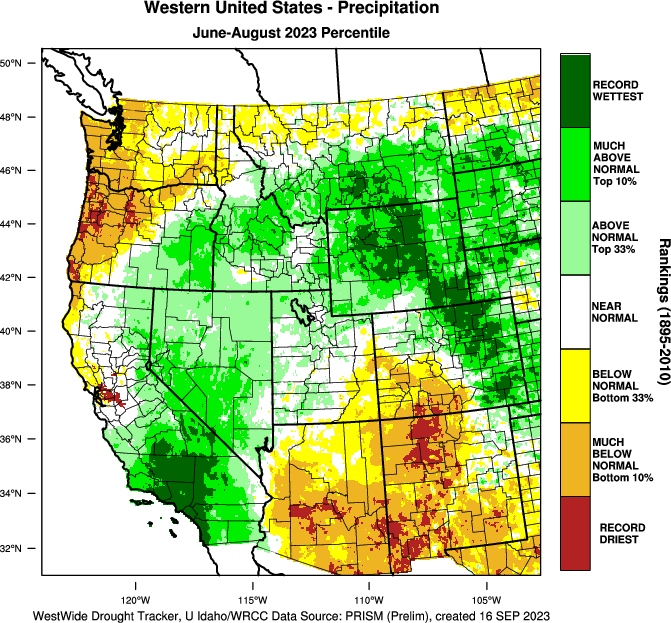
The real surprise, though, was on the precipitation side of things this summer: a remarkable alternating pattern of record dry (across portions of the Pacific Northwest and both AZ/NM) and record wet (across most of Southern California and in the Northern Rockies/Front Range of WY/CO). The swath of highly anomalous/record wet summer conditions across southern California and extending into the Great Basin was almost exclusively the product of heavy rainfall brought by the arrival of Tropical Storm Hilary–the first intact tropical cyclone over coastal Southern California in decades. That summer storm event broke (and in some cases shattered) daily, monthly, and even Jun-Aug summer seasonal rainfall records across some of California’s largest population centers, bringing locally major flooding and causing widespread disruption (though more extreme flooding, which was possible in such a scenario, was ultimately limited in scope). Meanwhile, the Pacific Northwest suffered through a worsening drought while parts of the interior Southwest saw their driest monsoon on record.
California’s wildfire season, with the notable exception of (ongoing) large fires burning in relatively dense forests of far northwestern CA, has been very mild to date. This was largely in line with seasonal predictions, which called for a much calmer fire season than recent years due to the remarkably cool and wet winter/spring that preceded it. Although climatological peak fire season is not over in California, the unusual summer wetness in SoCal and residual moisture from last winter/spring at higher elevations of NorCal, plus upcoming rainfall in the north (see sections below) suggest that the likelihood of major autumn fires in most of CA will be below average as well. The only possible exception will be portions of Central CA, which did not see much anomalous summer moisture and which will remain relatively susceptible to elevated fire risk during stronger wind events until the first major rainfall of the autumn (which is not yet on the horizon in that part of the state).
Autumn-like conditions emerging across CA: Some early season rain across portions of NorCal?
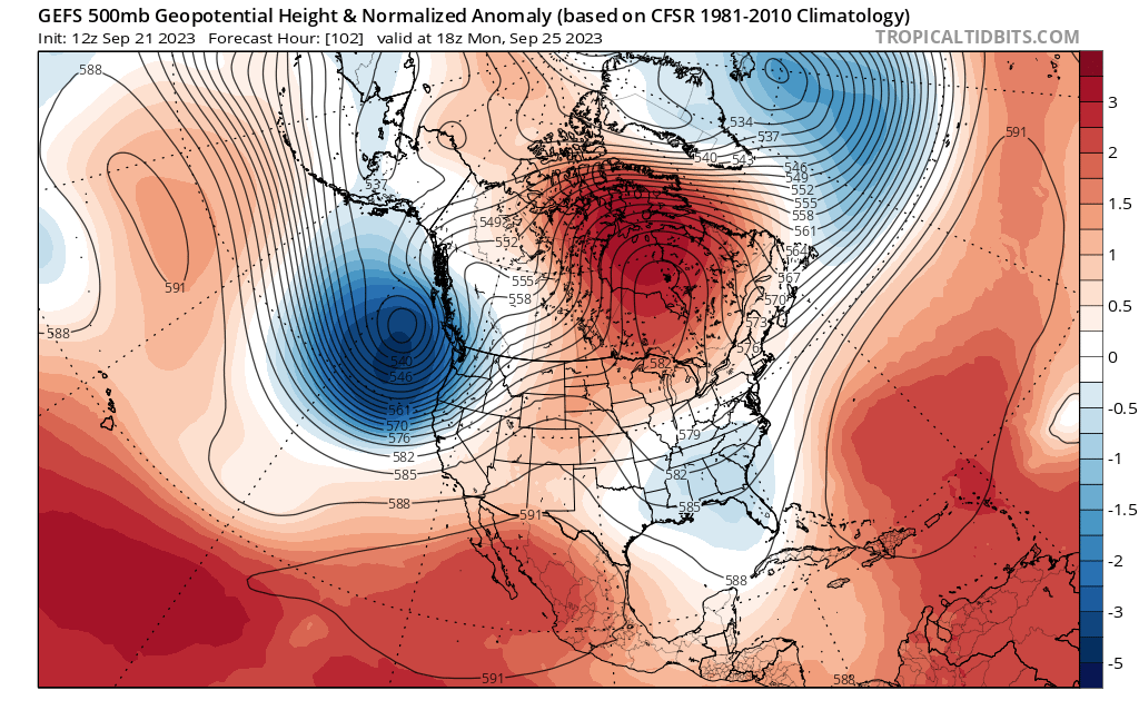
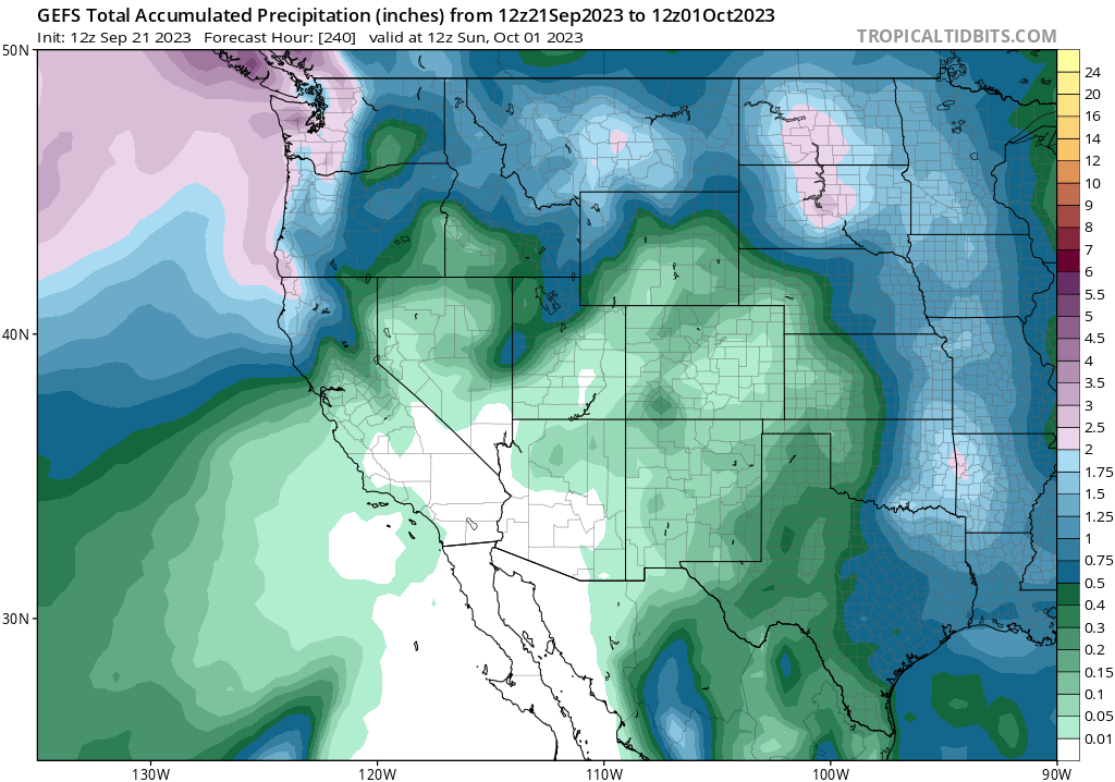
Well, I have some good news for those in NorCal dealing with lots of wildfire smoke this week: it’s on the way out, and an upcoming pattern change might prevent much more from being generated. An unusually strong early season low pressure system, and associated atmospheric river, will arrive in the Pacific Northwest by early next week. This will bring significant and likely fire-season altering/ending rainfall to parts of the PacNW coastal areas. The trailing front, while weakening, will also sweep across most of NorCal by Mon–bringing widespread rain to the North Coast and probably at least some showers farther south. A respectable 1-2 inches of rain could fall on the fire zone in NW CA–exactly what the doctor ordered there and really putting a damper on further fire growth/smoke production. Lighter showers may fall as far south as the Interstate 80 corridor or so, so a tenth of two of rain could fall as far south as the northern/central SF Bay region (though probably not much further south than that).
Will this rain end fire season? In parts of the PacNW and North Coast region of CA? Very possibly. In central California? Probably not–a strong offshore wind event later in Oct could potentially crank up fire risk again especially across coastal areas (though less so in the higher mountains, which remain moister than usual for this time of year). How about SoCal? Well, things are still damp in the wake of Hilary that far south–so although fire risk could reemerge if the coming weeks are very dry and/or windy, fire activity will likely remain pretty modest throughout much of CA during this period.
Cooler than average temperatures will be common over the next week over CA, though they may rise back to near or above seasonal levels by early Oct. Still, no big heatwaves of offshore flow events are currently on the horizon–making this Sep very different from recent ones.
Thoughts on the 2023-2024 winter to come: A strong El Niño event plus record global ocean warmth might make things interesting
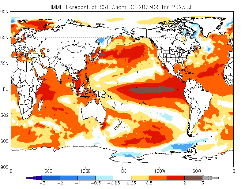
I did want to take some time today to discuss my thoughts regarding the upcoming winter (also the primary topic of discussion in my latest live YouTube weather and climate office hours session).
Overall, predictions of a strong to very strong El Niño event developing by late autumn appear to be bearing out–the Nino 3.4 region is now more than 1.5C warmer than average, which is generally considered to be the threshold for a strong event if sustained for a few months. But in addition to striking warmth in the eastern equatorial Pacific associated with this substantial and still strengthening event, there are also vast regions of remarkable non-tropical oceanic warmth elsewhere. In fact, record breaking (shattering?) marine heatwaves continue across both the North Pacific and North Atlantic as of this writing, and are not really expected to diminish greatly in the coming months. Thus, the current seasonal outlook involve El Niño event during Northern Hemisphere winter coincident with an extraordinary extent and magnitude of oceanic warmth in numerous other regions as well. That’s a global ocean configuration we’ve never seen before in recorded history, and definitely complicates the overall picture regarding what might happen with respect to Western U.S. hydroclimate in the coming months.
If a strong, east-based EN event were the only factor at play, I’d expect to see pretty classic/canonical El Niño teleconnections emerge: a strengthened Gulf of Alaksa low, enhanced subtropical jet over the eastern Pacific extending into the southern U.S., and substantially elevated odds of wetter than average conditions (especially later in winter/spring, from January trough March or April) across much of California (especially central and southern CA) as well as AZ/NM, with increased odds of unusually dry conditions in the Pacific Northwest (and Hawaii).
Overall, this is indeed what the seasonal models are depicting for the coming winter–though with substantial caveats and uncertainties. For reasons I discuss in greater detail during my last YouTube Office Hours session, the western U.S. hydroclimate response to ENSO is not only (or even primarily) due to the absolute ocean warmth. Instead, it’s in large part caused by changes in ocean/atmosphere temperature differentials and the longitudinal placement of displaced tropical thunderstorm activity–which generates Rossby wave trains (large scale undulations in the jet stream) that favor a deeper-than-usual Aleutian low and stronger than usual subtropical jet stream near California. Because the global oceans are extremely/record warm at present–not just in the El Niño region–that alters these differentials somewhat. I still think it’s likely we’ll see a large-scale response that at least somewhat resembles the classical “strong, east-based El Niño” one, with a strengthened Gulf of Alaska low and stronger subtropical jet over the northeastern Pacific. But there could be some adjustments given the extreme warmth of the non-tropical Pacific. That could 1) slightly offset the strengthened subtropical jet, but also 2) could also “juice up” any Pacific storms that do form by contributing extra moisture and latent heat.
So, what’s the TL;DR version? Well, there’s a lot going on in the global atmosphere/ocean sphere this year, with record-breaking oceanic warmth and a strong/very strong El Niño event very likely in place through mid-winter. That will raise the risk of worsening drought in the Pacific Northwest and Hawaii, but also increase the odds of a wetter than usual winter in California (particularly central and southern CA) and other parts of the interior Southwest. The odds of very heavy precipitation events will most likely be elevated beyond typical levels in California, particularly south of the Interstate 80 corridor. These effects, however, may not emerge until later in the season–from January onward, with little or no precipitation signal at this time for Oct-Dec in CA.
Of particular note may be the Southern Sierra and broader San Joaquin River watershed, which saw exceptional/record-breaking rain/snow in winter 2022-23 with major flood-related impacts (including the return of Tulare Lake). A second consecutive wet/very wet winter there could have amplified flood-related impacts, particularly if this winter’s storms are warmer than last years (which is pretty likely).
I’ll continuing to be following El Niño developments here on the blog as well as in my YouTube live sessions, so stay tuned!
Discover more from Weather West
Subscribe to get the latest posts sent to your email.