An autumn of precipitation whiplash in Northern California
For the first time in quite a few years, this was not an autumn of fire in California. Instead, the weather has been characterized by quite wet conditions in the northern 1/3 of the state–but nearly all that impressive autumn precipitation fell during a single 2-day storm event in October. That extreme atmospheric river event, which was the subject of the last blog post–broke numerous daily and some October monthly rainfall records throughout NorCal. Sacramento, for instance, experienced its single wettest calendar day on record since the 1800s. Despite this objectively extreme precipitation, resultant flooding was quite modest by comparison thanks to the antecedent extreme soil dryness and low river levels (courtesy of the early calendar date and the ongoing historic drought). This was–without a doubt–an example of an extreme precipitation event that was not a disaster given the context that surrounded it: it’s pretty clear this very intense storm brought more drought-mitigating benefits than flood-caused harms. Still, nearly all of NorCal, as of this writing, remains classed as experiencing severe to exceptional drought conditions–a designation that was only slightly reduced by all that October water.
On the other hand, while much of NorCal saw unusually wet (or even record wet) conditions in October, Southern California merely saw slightly wetter than average conditions. And November is shaping up to be a much drier month, in both relative and absolute terms, nearly statewide. SoCal has yet to see any precipitation this month (and, as I’ll discuss below, may not see any the rest of the month either. Temperature-wise, November has broadly been warmer than average (locally much warmer than average). But the spatial pattern of temperature anomalies has been striking in recent days: SoCal has been downright hot, with coastal temperatures approaching 100 degrees on some days. Much of interior NorCal, especially near the coast and in the foothills/mountains, have seen quite warm daytime temperatures as well. But much of the Central Valley has been socked in by very dense tule fog–resulting in daytime temperatures staying only in the 50s under grey skies with local drizzle. Tule fog is not an unusual winter occurrence when the ground is damp and atmospheric conditions stable, but it is pretty unusual to see it with ambient temperatures so warm (i.e., the foothills have been sunny and in the 70s while the Valley is stuck in the 50s under the fog layer).
Some modest NorCal showers this week, but otherwise quite dry for 2+ weeks statewide
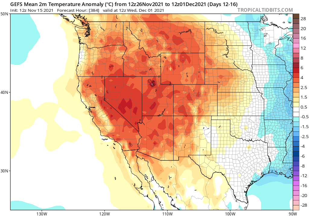
I’ll cut to the chase: the next 2+ weeks are looking quite dry for most of California, especially across the southern 2/3 of the state. There will be some modest showers this week in NorCal, and very light precipitation/sprinkles could make it as far south as the SF Bay Area, but the entire state is highly likely to experience below-average precipitation for the next 2-3 weeks.
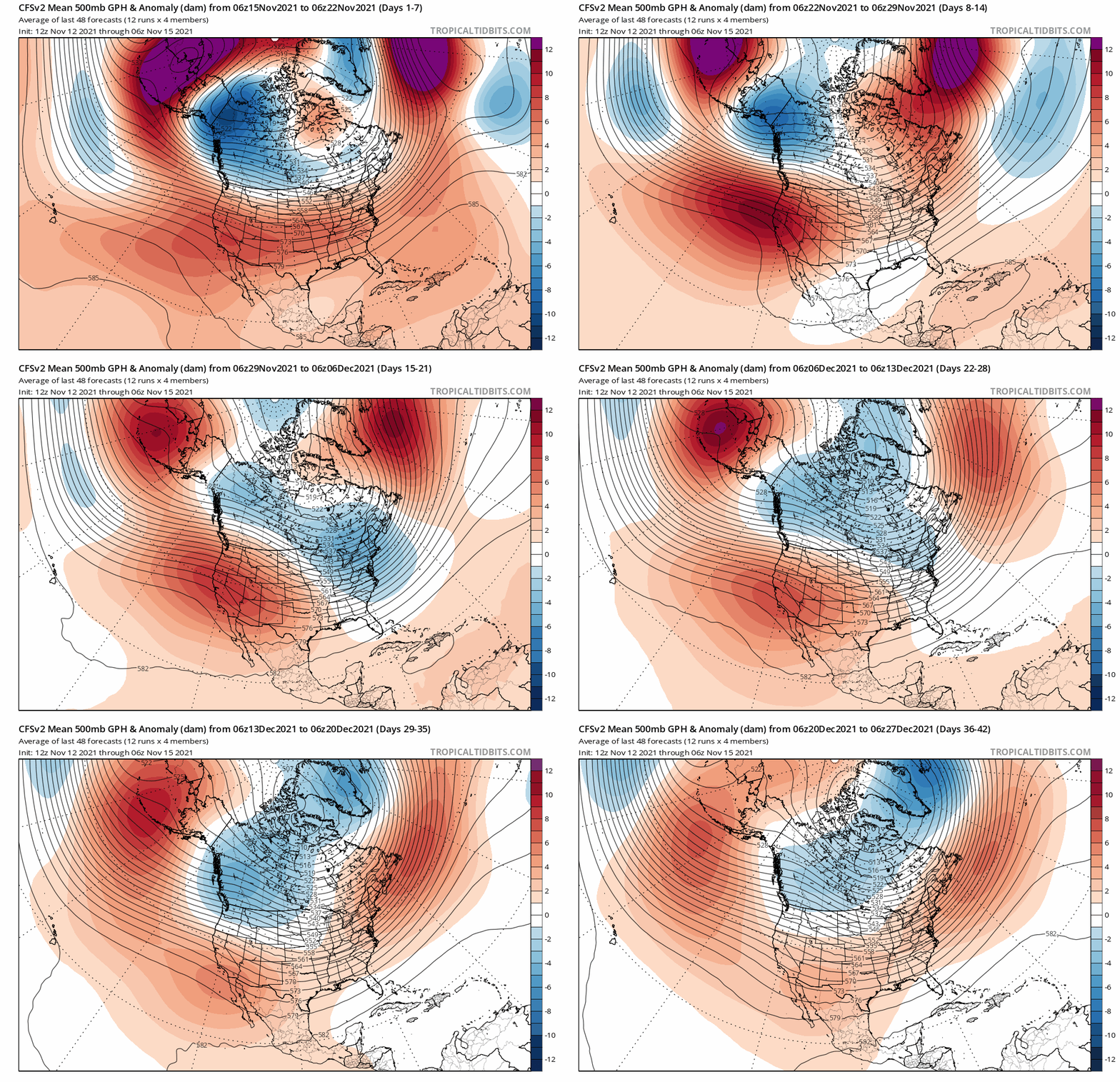
Persistent and rather strong ridging is expected to develop along or near the West Coast over that period, deflecting the Pacific storm track well to the north of CA. This could pose a big problem for parts of Washington and southern British Columbia, which are presently experiencing record wet conditions and widespread, severe, and worsening flooding. (Notably, some of the towns currently being completely evacuated due to flood and mudslide risk were also evacuated during the extreme wildfires in the very same river valleys this past summer following the record-shattering Pacific Northwest heatwave in June.)
Sub-seasonal outlooks continue to suggest an increased likelihood of NE Pacific ridging in a position that would likely keep much of California drier and warmer than average heading into at least the first week of December. This probably doesn’t mean a total “shut-out” for NorCal, as some relatively weak systems will probably break through the ridge at times to bring light precipitation. But it could very well spell a multi-week continuation of the warm and dry spell in southern California.

Drier-than-average winter still most likely outcome for most of California, though Oct rains bring silver lining
The good news about the extreme October atmospheric river is that, from a seasonal precipitation perspective, NorCal will be able to essentially keep pace with average even if the entire next month is dry. That’s because the Oct event brought 2+ months of precipitation in some areas over the course of just two days–pushing those spots well ahead of season-to-date averages. Not only did that moisten the landscape and end fire season up north, but it also provided a bit of a seasonal buffer against upcoming ridging.

But that buffer will last only so long–especially in the context of the very severe long-term drought. Seasonal models continue to sing the same tune as they have for months now, pointing to a rather high likelihood of a drier-than-average winter and spring to come (if anything, they are more adamant today than they were a couple of months ago). That is not too surprising, as La Nina has continued to strengthen and the West Pacific warm pool continues to provide a strong longitudinal ocean temperature gradient–a pattern very favorable for North Pacific ridging. I am reasonably optimistic that this year will probably not be as extreme dry as last year (this is already a foregone conclusion in a few NorCal spots that saw nearly as much rain from the Oct AR as during the entire Water Year last season), but on the other hand I don’t believe a major reversal of severe to exceptional drought conditions is likely across most of California or the interior West this winter. (Far NorCal, including the North Coast, stand the best chance of some continued modest improvement in drought conditions this winter). I’ll keep my eyes peeled for the next change of widespread significant precipitation, but at the moment, there really isn’t any on the horizon. Stay tuned!
Discover more from Weather West
Subscribe to get the latest posts sent to your email.