Stronger cold storm this weekend in NorCal, then warmer and quieter weather to follow. Plus: seasonal outlook and El Niño update…
Record-warm December in parts of California (and much of the U.S.), with abysmal Sierra Nevada snowpack, despite record downpours on Central Coast
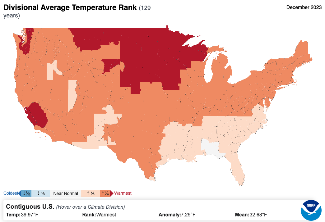
December was an extraordinarily warm month globally and nationally (the warmest December on record both globally and generally across the United States). All of California experienced a much warmer than average month, and some regions (particularly in central CA, including the San Joaquin Valley and Central Coast region) also experienced their warmest December on record.
Precipitation was much more of a mixed bag, ranging from drier than average across the Sierra to wetter than average along the Central Coast. Notably, extreme thunderstorm downpours from a slow-moving cut-off low pressure system, characterized by unusually unstable air (aided in part by unusually warm near-shore ocean temperature) and a robust subtropical jet (perhaps thanks to El Nino and other tropical goings on) produced some of the heaviest hourly rainfall ever observed in non-mountainous California: over 3 inches in a single hour in and near Ventura. (Exactly where this falls in the record books will be the subject of some investigation and debate to come, but there’s no doubt it caused widespread and locally severe flash flooding across Ventura County.)
Sierra snowpack was…well, pretty abysmal, with some areas having almost no snow on the ground on New Year’s. 2023 brought either the worst or second worst start to the snow water accumulation season on record in some parts of California (as well as other parts of the Southwest) due to this combination of extremely warm temperatures and low precipitation. Snowpack conditions have improved modestly in recent days as colder storms have finally arrived, but unfortunately the sudden arrival of a couple of feet of drier powder atop a very thin and icy base layer may have destabilized the snowpack and set the stage for what appears to have been a deadly avalanche at Palisades Tahoe this morning.
Stronger, colder storm for NorCal this weekend as dramatic Arctic outbreak narrowly misses CA to east
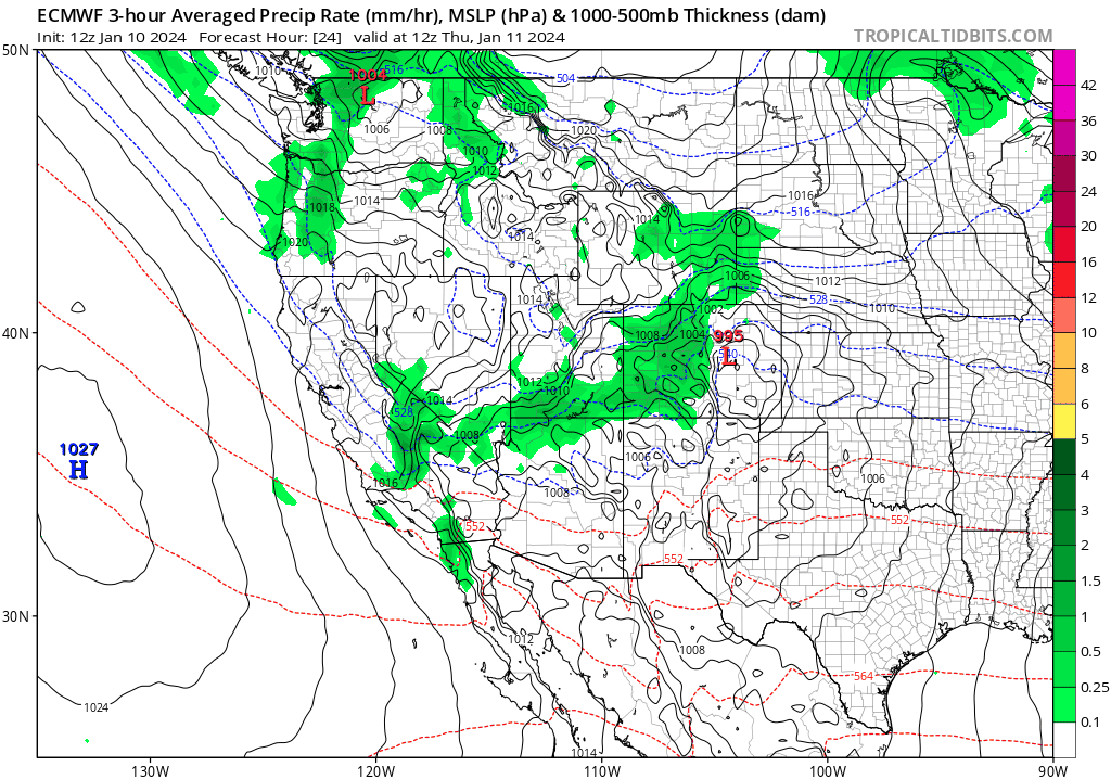
In the short term, there is good news for NorCal: a pretty healthy and rather cold system is slated to move though at least the northern half of the state Friday into Saturday. This system will be interacting with a bitterly cold continental Arctic airmass that is spilling southward out of Canada and may bring lowland snowfall to parts of the Pacific Northwest and perhaps historic blizzard conditions across the upper Midwest in the coming days. In California, this storm will be decidedly less extreme. But where there is some drama is the striking difference between the GFS and ECMWF (and their respective ensembles’) depictions of the incoming storm. The GFS is generally weaker and farther north, bringing a weak to moderate system to NorCal characterized by moderate to briefly heavy precipitation and some breezy winds. The ECMWF, however, has been hinting at the potential for a moderate to strong storm and associated robust atmospheric river making landfall this weekend, which could bring more widespread and prolonged heavy rainfall (with local/minor North Coast/NorCal flood issues), stronger wind gusts, and blizzard conditions to portions of the Sierra Nevada. These distinct inter-model differences have persisted for several days, which is unusual, and suggests that one of them (probably the ECMWF, given its more advanced data assimilation system) is probably honing in more correctly on some details in the initial atmospheric conditions that result in significant forecast differences just 48 hours out. In this case, I’d lean toward the ECMWF depiction of a pretty strong storm affecting NorCal Fri and Sat, with a very healthy dose of lowland rainfall and mountain snowfall along with gusty winds.
Unfortunately, as has been the case recently, this system will weaken and mostly wash out before making it to Southern California–so while some light showers are possible the bigger story might (once again) be cool temperatures and gusty winds down south. Not an especially Nino-like pattern at the moment, I’m afraid!
A trend toward warmer and (even) drier later in January. (Yes, yes, I know)
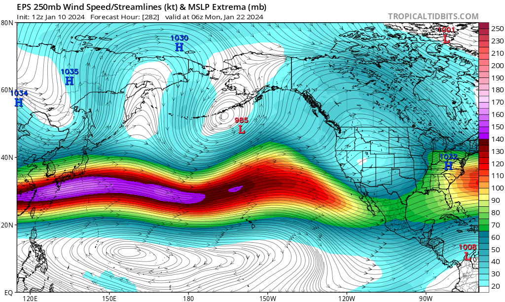
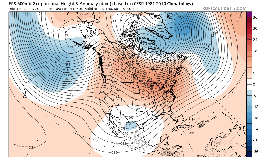
So…what about the weeks to come? Well, the model ensembles are suggesting renewed potential for a pacific jet stream extension, reaching at least the Central Pacific by later in January. But as we know all too well from recent experience, that extension can be a double-edged sword: if it makes it all the way to the West coast, a wet and active storm track can result. But if it terminates too far offshore, it can actually help pump up a ridge just upstream (to the east) that deflects storms away from California. And at least initially, that unfortunately looks like what’s most probably going to happen: despite a robust Pacific jet and enhanced subtropical jet south of California, the extension will contribute to West Coast ridge building and bring a period of much warmer weather (yes, again) and probably drier than average conditions as well.
Now, eventually, as this jet extension either retracts (and Rossby wave breaking occurs, disrupting upstream ridging) or further extends (bringing an active storm track all the way to the West Coast), this outlook may change dramatically. Eventually, such a jet extension could bring a more active (if still warm) pattern, characterized once again (as during portions of Dec) by systems with considerable subtropical influence.
But I would not expect that to happen for at least 10-14 days at this juncture. One challenge is that the Madden-Julian Oscillation (MJO) has not really cooperated so far this winter despite promising forecasts, often offering destructive interference with the El Nino forcing that might otherwise bring more storms to central and southern CA. So far, those two factors haven’t really aligned in a way that helps for any sustained period, and for this reason things have been awfully dry in SoCal in recent weeks. There has also been some pretty extreme Arctic/Greenland blocking (i.e., persistent high pressure) in recent days that has led to extreme weather across most of North America except for California, with powerful storms along the Eastern Seaboard bringing record-breaking storm surges, extreme December rainfall, perhaps even a pair of historic back-to-back snowstorms in the Midwest, and unusually substantial sea-level snowfall in the Pacific Northwest. But that same blocking causes an atmospheric “traffic jam” upstream, causing storms over the eastern Pacific and western U.S. to meander in a way that is not especially conductive to reinforcing the El Nino-strengthened subtropical jet.
El Niño update: what’s next, and what gives?

The comments section on Weather West has been abuzz in recent weeks, and…I get it. This winter has been weird and frustrating thus far, and even ensemble modeling has been consistently inconsistent (and, frankly, wrong more often than not in the long range). I can’t claim to have all the answers; this will be yet another season that will be studied in retrospect. We do have strong to very strong El Nino conditions present in the Pacific; that was a very good prediction by the models many months in advance.
But we also have a planet that is warmer than it has ever been before in recorded human history–including patches of non-tropical oceans that have remained much warmer than average or record warm for many consecutive months. Scientists, including me (in previous blog posts!), have speculated that historically unprecedented combination of extremely warm extratropical oceans might interfere with the long-range hydroclimate teleconnections associated with what otherwise looks like a top-tier El Nino event in the tropical Pacific. It’s quite possible that is what’s happening this winter, but we won’t be able to confirm whether or not that’s actually true for a while (such studies take time).
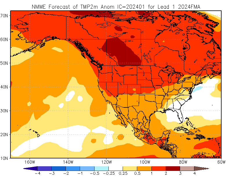
The latest suite of updated seasonal modeling came out yesterday, and it looks decidedly different than previous modeling cycles. The fairly substantial tilt toward wetter than average conditions this winter in central/southern CA that was present during Jan-Mar in previous iterations is now gone. If anything, it’s replaced with a very slight tilt in the odds toward drier than average conditions across most of California and the Southwest from Feb-Apr. Now, it’s important to emphasize that what the models are now suggesting is that there is now essentially no meaningful signal for CA precip over the next 3 months: wetter, drier, or near average precipitation are nearly equally likely to occur. That does NOT mean that precipitation will actually be near average; in this case, I really think it’s an indication of very high predictive uncertainty amid very unusual atmospheric and ocean conditions globally.
It is possible that this latest model cycle initialized during a period of incoherent MJO signal, and so if the MJO ends up getting its act together and moving across the Pacific in a way that can align in-phase with El Nino’s influence in the coming weeks or months, we may end up having a very robust storm cycle. That remains a distinct possibility. But there are no guarantees, and with this much uncertainty regarding large scale influences moving forward it’s tough to say more than that at this point.
One area where there is very little uncertainty is with temperature predictions: it’s very likely to be much warmer than average–and perhaps record warm in some areas–for most of the rest of the cool season (winter and early spring). In fact, after the present Arctic outbreak departs central North America in a week or so, dramatic warming may ensue once again. This means that even if an active storm cycle does return to California, Sierra and Lower Colorado River Basin will likely continue to struggle due to warm temperatures. So at this point I would expect snowpack in California and much of the SW to end up below average for the season even if precipitation picks up considerably in the weeks to come simply by virtue of this very high likelihood of anomalously warm temperatures for most of the next few months (and perhaps beyond).
My next live YouTube “Virtual Office Hours:” Thu, Jan 11 at 2pm PT
Join me on Thursday, January 11th at 2pm Pacific Time for further discussion, in live Q&A format, of the California weather and subseasonal climate topics above as well as broader reflection on 2023 as the Earth’s warmest year on record: what it means for the planet and for California.