As historic March heatwave finally fades, a brief cooler/wetter interlude will occur across the U.S. West in early April before warmth & dryness likely return
Unprecedented March heatwave among most anomalous ever observed, in any month, the American Southwest
Well, it sure has been…quite a month.
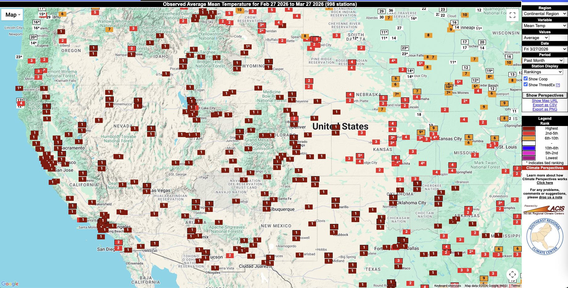
Meteorologically speaking, March 2026 will go down in the record books as the warmest March on record for at least a third, and possibly half or more, of the continental United States. But even more remarkable is the ~10 day window of peak heat during this truly exceptional March heatwave–when many, if not most, locations across the western two thirds of the United States in a broad swath stretching from the Pacific Coast in California eastward past the Mississippi River broke their all-time March monthly heat records. The margin by which March heat records were shattered was so wide that more than a handful of locations also broke their all-time April heat records, and in a few locations even tied or broke their May heat records! Many locations also experienced multiple successive dates of all-time record breaking during this same heatwave, with temperatures from early in the event (themselves record-breaking) going on to be exceeded once again on 1 or more additional subsequent dates (in some cases, nearly all high temperatures in some locations for a week or more would have broken previous monthly records).
There has already been quite a bit of informal analysis of this exceptional and record-shattering heat event, and preliminary data suggests it was likely among the most statistically anomalous extreme heat events ever observed in the American Southwest–not just in March, or even the cool season broadly, but at any time of year. In other words: there has never been, in all of recorded history, a Southwestern U.S. heat event that yielded departures from typical seasonal temperatures as large as what were observed during the March 2026 event. And it’s not even close, as this striking visualization from Nahel Belgherze below illustrates.
To be clear: hotter temperatures have certainly occurred during severe heatwaves closer to the peak of summer, but it is exceptionally difficult for the Earth system to produce temperatures this warm so early in the season. The days are simply shorter, and the sun’s cumulative heating potential simply weaker, than they would be closer to the summer solstice. Plus, there is typically extensive snow cover on the ground in mountainous areas during March (as there was, relatively speaking, at the beginning of this heatwave). Overall, that means that the atmosphere is at a significant thermodynamic disadvantage at this time of year even when persistent ridges occur. Yet this record-shattering heatwave happened anyway, despite all the seasonal factors working against it.
By some statistical metrics, the March 2026 heat event in the Southwestern U.S. was likely comparable to the June 2021 event in the Pacific Northwest and British Columbia. Had a comparably or even somewhat less statistically anomalous event occurred later in the season–even in May or June–it is likely that many locations in the Southwest would have exceeded their all-time, any-month record temperatures.
As noted in my last blog update before the extreme heat event began, there was likely a substantial contribution to the magnitude and persistence of the Southwestern heat dome during this event by highly anomalous upstream diabatic heating in the Central Pacific, which was related in turn to record-breaking rainfall and severe flooding in Hawaii. Such extreme precipitation events arising in extremely moist tropical/subtropical airmasses can result in the conversion of large quantities of latent heat to sensible heat as condensation occurs continuously and intensively for days; that additional sensible heat can be transported for thousands of miles downwind via the jet stream (and through atmospheric river corridors, like the one draped over the Pacific Northwest and BC for much of this event). There is a growing body of research on so-called “diabatic ridge-building,” which is known to amplify the persistence and amplitude of blocking ridges preferentially; there can also be an additional amplification to extreme surface heat within persistent ridges thanks to the advection of air masses with increased static energy contributed by both vertical lifting and latent-to-sensible heat conversions in the stormy areas upwind.
Finally, I want to emphasize that the links between record-shattering heatwaves and climate change are unambiguous at this point, even without having seen any specific new analyses regarding the particular March 2026 event. That’s because baseline warming, which is already considerable, directly raises the ceiling on how intense the very most intense heat extremes can become. But that baseline estimate, according to a broadening array of evidence, is probably a conservative (meaning: lower-bound) one relative to the true contribution for a variety of reasons. Such approximations generally do not fully account for any of several plausible and likely relevant self-amplifying feedbacks by which extreme heatwaves can intensify–including those related to soil moisture, contributions from upstream diabatic heating (as discussed above), or other shifts in large scale weather patterns that can contribute to heatwave development and intensification. Most of these recognized potential heatwave feedbacks are intensifying, at least in their most extreme iterations, thanks to the (figurative) “expanding atmospheric sponge.”
Now, it’s important to understand that these kinds of feedbacks and the Earth system processes behind them remain at the cutting edge of science; they are not easy to represent in process-based models, and there are considerable uncertainties that remain. There are genuine scientific disagreements regarding just how large, and widespread, these effects are today and will become. But despite this, my own professional view is that we’re far more likely to be underestimating–and therefore understating–the climate change contribution to (specifically) record-shattering heatwaves than we are to be overstating them.
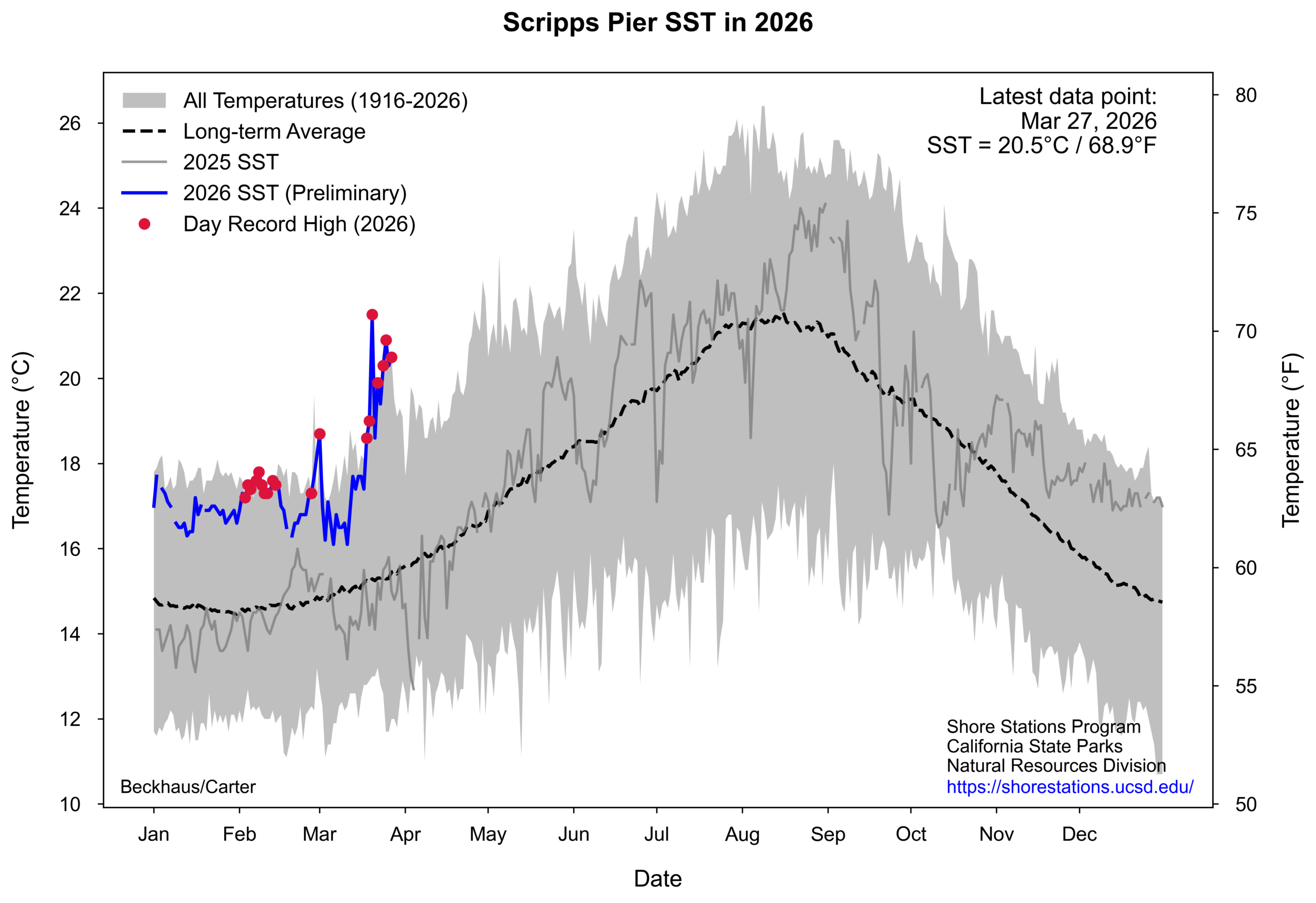
Not to be outdone: near-shore ocean surface temperatures (SSTs) have now reached record-high values along much of the central and southern California coast. As measured at the Scripps Pier at the peak of the March heatwave, temperatures were so extreme they would have broken records for most days in June, let alone March. Even with recent “cooling,” SST in the SoCal Bight are still at calendar date record maximum levels and that appears likely to continue for days or even weeks to come.
Western snowpack, including in California, takes historically unseen March nosedive and will reach record lows by April 1
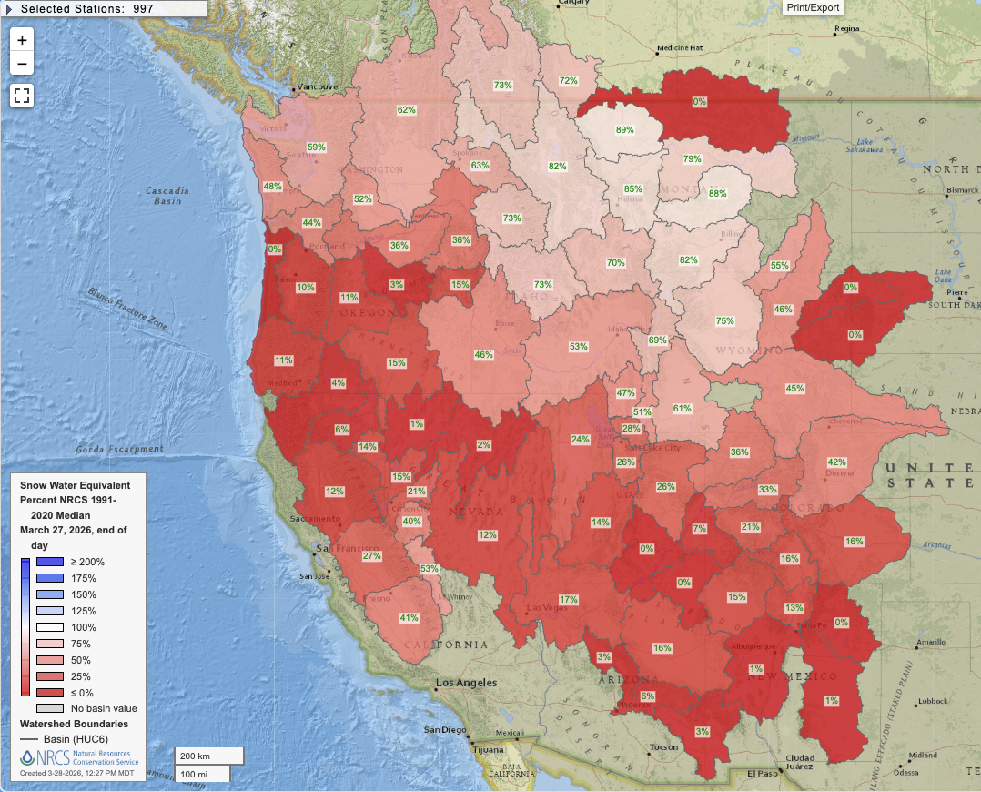
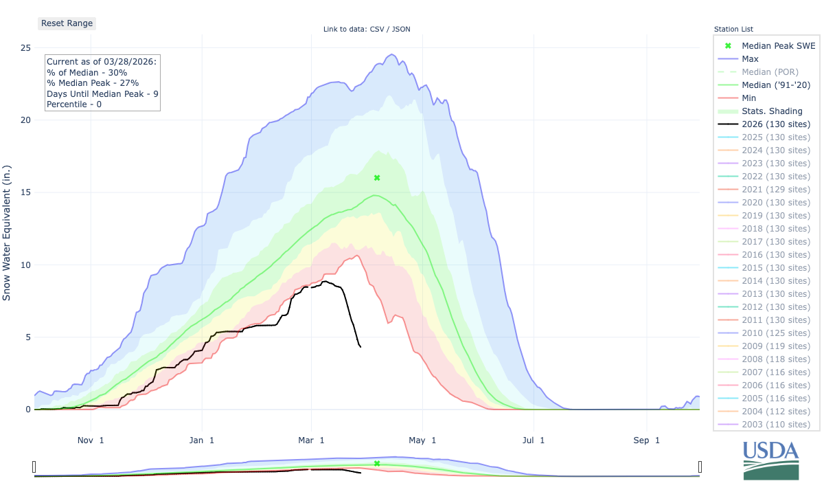
Beyond the conspicuous “weirdness” of it all, the most consequential longer-term impact of our record-shattering March heat will likely be the decimation of the Water Year 2025-2026 snowpack across nearly all of the American West. As earlier noted, snowpack was already well below average and was running close to all-time record lows in some areas even before the March heat event. But now, with the worst of the heat in the rear view mirror, the toll wrought on our “water tower in the sky” is nothing short of shocking. In California, mountain snowpack is now tied for its worst value on record for late March (the previous record was 2015), which is truly remarkable given that one of the largest single Sierra snowstorms in decades occurred just weeks ago in February. As of March 27, California mountain snowpack had fallen to only ~10% of the historical median for the calendar date. And in some locations the on-the-ground reality is even worse than it appears: this year, most of what SWE remains is at very high elevations (having fallen during warm but very wet early season storms), and lower slopes are now completely bare nearly statewide.
In fact, if the current extreme melt rate were to be sustained, there would be essentially no snowpack left at all within 10 days (i.e. in early April). Now, I do expect the SWE loss rate to slow over the next few days and perhaps briefly stabilize later this week amid cooler temperatures and some precipitation. Also, the last inch or so of SWE is somewhat elevationally “protected.” But I still expect that SWE loss will likely resume at an usually high rate shortly thereafter–raising real prospects of the earliest SWE melt-out on record for CA.
In California, one highly fortuitous saving grace is that this extreme heatwave and snow drought is not co-occurring in the context of a severe multi-year drought and associated water supply shortage. Major reservoir levels in the state are uniformly at or above average seasonal levels; recognizing the historic precarity of the situation, reservoir operators are allowing reservoirs to fill as much as they possibly can within flood pool safety margins as this very early snowmelt occurs. We are lucky the precipitation in California this winter was generally decent, and was often above average over the past few years.
But all the snow that melts now is snow that won’t melt later, and which largely cannot be captured by reservoirs later in the season as part of a gradual warm season replenishment (which is how the system was designed to operate in a cooler historical climate). This means that the situation is both better, and also worse, than it superficially appears: there is is plenty of water in the big reservoirs right now to get California through this year, despite historically bad snowpack conditions; however, it’s also true that there will be a historic divergence between spring reservoir levels and their likely rapid draw-down later in the season due to lack of new snowmelt-derived inflows beginning as soon as late April and likely continuing until the beginning of the next rainy season.
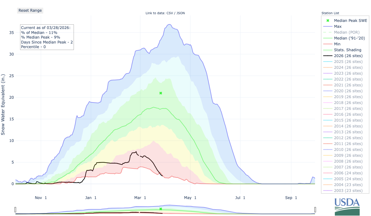
In the Colorado River Basin, however, the situation is far more dire. Here, a severe and pre-existing multi-decadal drought has already forced a contentious water allocation debate as demand greatly outpaces supply; now, the record warm Water Year 2025-2026 is threatening to throw this crisis into even higher gear. The record-shattering March heatwave reached even the highest elevations of the Rocky Mountains (and continues to, even today, with yet more daily-to-monthly records being set this weekend), bringing about what I can only describe as an unprecedented collapse of Colorado Basin snowpack during what would usually be the very peak of seasonal accumulation. While Colorado Basin SWE had already been tracking near/below modern record lows for most of the season (SNOTEL records are reliable back until the early 1980s), there were likely still one or two pre-1980 snow years that were worse through early March. Since then, however, CO Basin snowpack has taken a nosedive and has in recent days reached all-time record lows for the calendar date by any measure I can discern–even relative to the pre-1980 era.
In fact, in writing this blog post, I was pretty shocked to see how stark the numbers truly are. As of March 28, Upper Colorado Basin SWE was around 4.3 inches. That compares to a calendar date median of 14.3 inches, and a SNOTEL-era record low of 10.3 inches. That means that CO Upper Basin snowpack is nearly 60% below the previous SNOTEL-era record low for this time of year. This is even more notable given that this basin is at a comparatively very high elevation relative to much of the rest of the West, where high peaks are more isolated; there is therefore much less historical variance in the seasonal peak than there is in a place like California as baseline temperatures are typically much colder. While I also expect the rate of SWE loss to level off later this week here, as well as in California, there are still several more days of highly anomalous heat to go in this region before that occurs. The damage, unfortunately, has largely already been done.
Some good short-term news: An early April reprieve is on the way, with much cooler temperatures and some (modest) precipitation in some areas
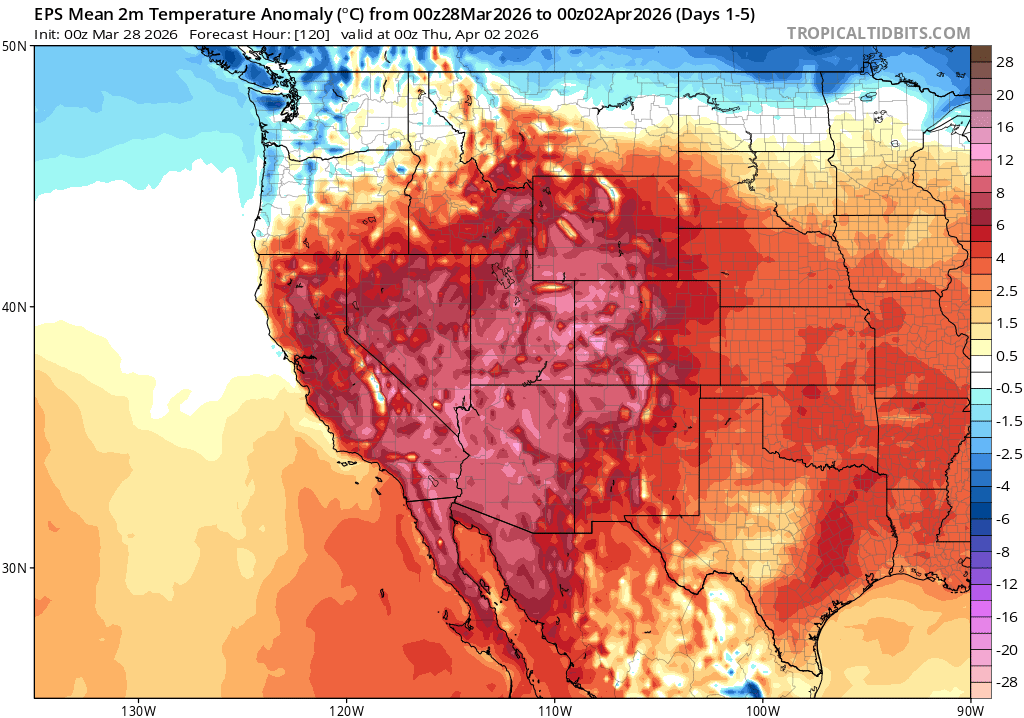
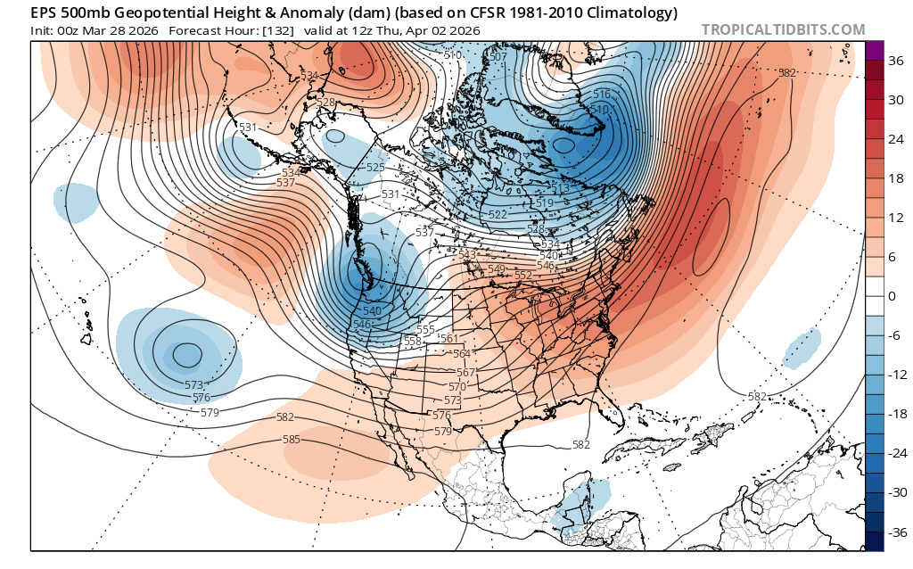
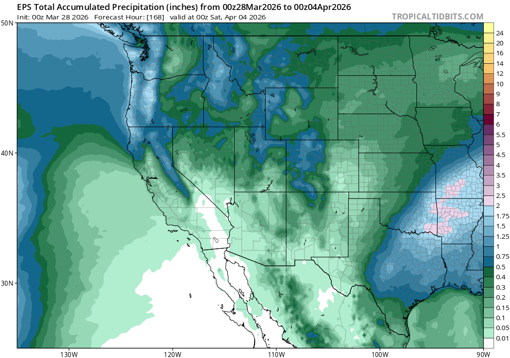
I do have some good news to offer, tempered though it might be: a pattern change toward cooler, and at least locally wetter, conditions is on the near-term horizon. The ridiculous ridge will persist a couple of more days before finally being replaced, for at least a few days, by a fairly transient trough. This trough and associated low pressure system will definitely bring much cooler and breezier conditions (though this will be relative, with temperatures cooling to near average or slightly below for a couple of days). It will also bring some widespread precipitation to the Pacific Northwest, northern and central Rockies, the California North Coast, and probably also the northern/central Sierra Nevada. Precipitation will not be heavy; no locations are expected to see more than 1-2 inches of liquid equivalent over the next 7-10 days and most lower elevation locations will stay well under 0.5 inches. Some showers will be possible into Central California, including the SF Bay Area and Sacramento region; SoCal will likely stay dry outside of possibly a few sprinkles.
The first wave of this system will be pretty warm, and I would expect mostly rain event on the mountaintops out West. The second wave of the system will likely be colder, and will bring a higher potential for at least some modest accumulating snowfall at more reasonable elevations later in the week. But ground temperatures will be warm, and snowfall is unlikely to be heavy, so there probably won’t be much lasting accumulation except at very high elevations.
I will also add that there is a bit more uncertainty with this upcoming pattern than would typically be the case 5-7 days out. There is a slight chance that these systems come in somewhat stronger, and colder, than currently indicated. But there is also a chance that they fall apart almost completely, bringing little or no meaningful precipitation. Right now, it appears the most likely outcome is somewhere in between–with a pretty typically impressive April system that nonetheless offers welcomed relief from recent record heat and prolonged dryness.
Warmer than average conditions favored overall for the rest of spring (and summer, and…)
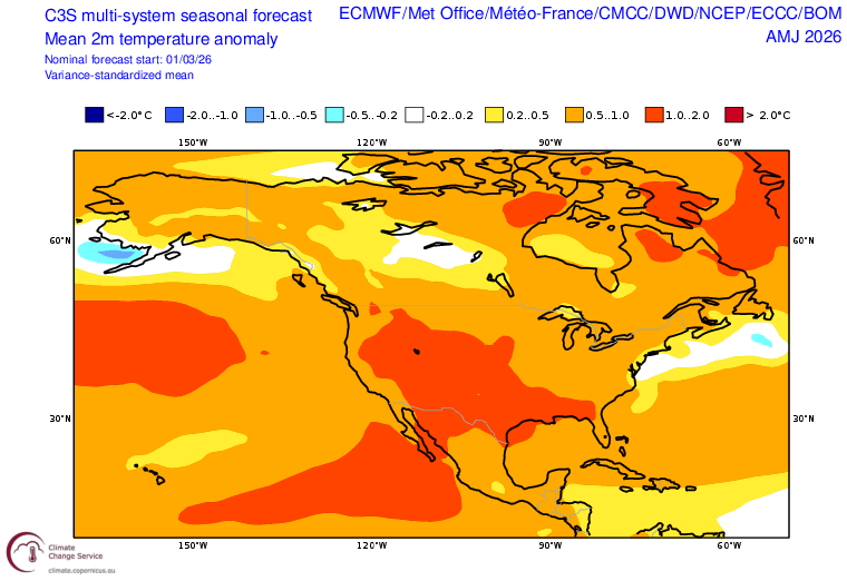
The general trend, looking ahead to mid-April, is warming and drying once again. In fact, model ensembles are in moderately strong agreement that another (albeit weaker) ridge will develop broadly across the Western U.S., bringing another period of warmer than average temperatures and lower-than-typical odds of April precipitation. This dry spell is less of a “slam dunk” than the last one–and there are in fact a handful of ensemble members that allow a sneaky springtime cut-off low to bring some robust April showers later in the month. But right now, ocean conditions and atmospheric model outlooks suggest higher than average odds of warmer than average temperatures (with high confidence) and drier than average conditions (with somewhat lower confidence). In fact, looking ahead to the rest of spring and early summer, there remains very strong consensus that the entire American West (including the immediate California coast, which is notably different from recent springs) will experience much warmer than average conditions. That does not mean California and the West wont see some additional spring precipitation–and even accumulating mountain snow, if we’re lucky–but right now the overall signal points squarely toward anomalous warmth being the name of the game for the final weeks of the wet season. I’ll discuss this in more detail in my upcoming YouTube livestream on Tuesday.
YouTube live update on record-shattering heatwave, historic loss of snowpack, and near-term cooler/wetter interlude
See you on Tuesday at 2pm Pacific Time! It will be recorded, as always, in case you can’t make the livestream and will be available thereafter at the same link below.