Remarkable California wet spell continues
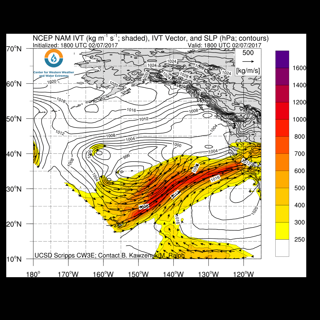
This will be a brief update due to time constraints, but given the widespread and somewhat more significant than anticipated storm impacts across Northern California today, the next storm bearing down on the state bears close watching. An intense atmospheric river brought widespread heavy rain and strong winds to much of NorCal early this morning, causing widespread flooding of streams, smaller rivers, and coastal areas (especially near the Bay Area). Observed flooding and other storm impacts were more severe than initially anticipated–partly because the frontal structure (and therefore rainfall rates) were a bit more impressive than expected, but also because soils throughout the region have now reached total saturation (and, in some cases, “supersaturation”). Thus, virtually all rainfall at this point is generating rapid runoff and flowing into bodies of water that are already experiencing residually high flows. Additionally, the threat of both smaller mudslides and deeper landslides is now quite high across much of California–as evidenced by numerous road closures in recent days.
After one of the wettest starts to the rainy season on record, California’s water capture and conveyance infrastructure is now under considerable strain. In addition to the longstanding threat of levee failures in the Delta (and elsewhere) under high flow conditions, the concrete spillway on the Oroville Dam in Butte County has apparently been compromised by erosion due to controlled high-flow releases this morning. While this damage does not threaten the integrity of the dam itself, the spillway is currently unusable–which prevents dam operators from releasing enough water to counterbalance the very high inflows that are expected to continue for at least the next 72 hours. The California Department of Water Resources is confident that existing contingency measures will be sufficient to prevent bigger problems in the short term, but with more heavy precipitation on the horizon in the 7-10+ day period, this will be a development to watch closely in the coming days.
Reinvigorated “Pineapple Express” on Thursday; more flooding concerns
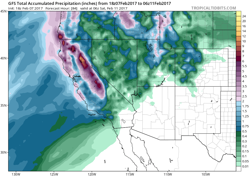
Another strong surface cyclone off the coast of California will position itself in a manner that will act to “resurrect” the existing plume of subtropical moisture transport initiated by the storm earlier today. Thus, a reinvigorated warm and very moist atmospheric river will move across northern California on Thursday–bringing another threat of very heavy rainfall (especially in the mountains and foothills). Cumulative totals in most urban areas will not be enormous–likely on the order of an inch or two–but rainfall rates could be quite high for a time along with strong winds. Flash flooding and urban flooding is again likely in parts of the Bay Area and Sacramento Valley, and it is possible that flood impacts could again be elevated above what would usually be expected from this strong (but not particularly extreme) storm. It is worth noting that the watersheds that drain into the Oroville Dam are expected to see 6-7+ inches of additional rainfall between now and early Friday. Southern California will largely escape any flood concerns with the Thursday system, although light to moderate rainfall may linger into Friday. Also of note: high snow levels, and warm rain at relatively high elevations in the Sierra Nevada, could cause additional problems with local flooding and even roof collapses as water-laden snow accumulates.
Strong multi-model agreement on brief break, then return to (very?) wet pattern in 7-10 days
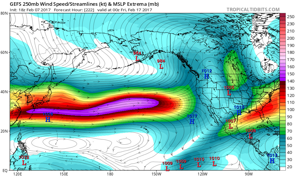
By the weekend, all of California will experience a much-needed respite from the deluge. In fact, a 5-7 day dry spell is looking pretty likely at the moment. But by mid-February, there is already remarkably strong multi-model agreement that a wet (and perhaps very wet) pattern will resume across California, and this time the entire state from San Diego to Eureka will probably get soaked. Yet another impressive eastward extension of the Pacific jet stream will probably bring the storm track right to our doorstep in that timeframe, and at this very early juncture it looks like there could be the potential for strong wind events in addition to heavy rainfall events. That would most likely raise the spectre of significant flood concerns once again.
Whew.
Many of you are probably wondering: why, exactly, is California experiencing such an extraordinarily (and unexpectedly) wet winter? Well, that’s a question for another blog post–partly due to time constraints, but also because the answer is not immediately obvious. Once things calm down a bit later this year, I’ll revisit this topic (and perhaps there will be some new research available to discuss at that point). In the meantime, I’ll still be providing real-time updates on Twitter.
Discover more from Weather West
Subscribe to get the latest posts sent to your email.