Recent storms set stage for high-impact event today

This will be a brief update, but given the widespread significant storm impacts expected later today I felt a quick post was in order.
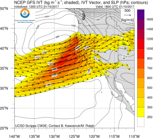
A very warm and wet “Pineapple Express”-type atmospheric river (with origins in the subtropics) brought widespread rainfall to California over the weekend, even at very high elevations in the Sierra Nevada. Flooding, mudslides, and avalanches shut down most major travel corridors through Northern California on Sunday for at least some period of time, and a number of larger rivers have approached or exceeded flood stage.
Early model forecasts for this weekend storm were remarkably on-target, especially with regard to the large-scale storm details. One modest mitigating factor that prevented the weekend storm from bringing even more severe impacts was the slight lag between the arrival of the deepest atmospheric moisture and the arrival of the cold front. This “phasing issue” meant that while orographically favored higher elevation areas saw the expected prodigious rainfall totals, areas near sea level or “rain shadowed” by mountain saw less precipitation than otherwise would have occurred.
Another very high-impact storm across NorCal today. Widespread hvy rain, flooding,&strong winds. Extreme blizzard Sierra Nev. #CAwx #castorm pic.twitter.com/BVEprOVPtv
— Dr. Daniel Swain (@Weather_West) January 10, 2017
Soils are completely saturated and rivers already running very high following this weekend’s storm, however, and now a new storm is bearing down on California this afternoon. Since virtually all precipitation that falls over the next 24 hours will immediately turn into river/stream runoff, the flood threat later today may actually be higher in many places that during the weekend storm.
Very heavy rain, locally very strong winds, and epic blizzard conditions in Sierra Nevada

Today’s storm will bring an wide range of severe weather conditions to Northern California over the next 18 hours.
Steady soaking rains will intensify this evening, possibly culminating in a very intense burst of precipitation at some point tonight as the strong and fairly convective cold front passes through. This steady ramp-up of precipitation intensity, followed by a final burst of rain rates possibly approaching 1 inch/hour, will likely lead to widespread flooding given already wet antecedent conditions. In some parts of the Bay Area, Sacramento Valley, and Sierra Nevada foothills, life-threatening flash flooding of streams and smaller rivers could result. In addition, larger rivers from the Santa Cruz Mountains northward to the Mendocino coast may respond rapidly to this additional rainfall, possibly leading to the highest flood levels in years. The Sacramento River will reach its highest level in at least a decade, flooding the Yolo Bypass. Large and dangerous mudslides have already started to occur in many places, and this risk will remain very high for at least the next 24-48 hours in areas of steeper terrain and near recent wildfire burn scars.
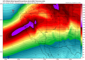
Very strong winds are also possible near the time of cold frontal passage this evening. In the hills and in other wind-prone locations, wind gusts in excess of 65 mph are possible (and winds greatly in excess of 100 mph are likely on remote, high elevation peaks in the Sierra Nevada). Of potentially even greater consequence will be wind gusts over 50 mph in less wind-prone urban areas in the Bay Area and Sacramento region, where widespread power outages and tree damage is likely. Wind impacts with this storm will likely be more significant than with the Sunday storm.
With strong storm-scale dynamics, increasingly cold air aloft, and a fairly well-defined cold frontal passage this evening, thunderstorms will be possible (especially near the coast). Some of these could even approach severe limits, bringing torrential downpours and very strong wind gusts.
#Blizzard Warning for the #Sierra. Life threatening blizzard conditions: whiteout conditions & high avalanche danger https://t.co/4B6tdCrxZj pic.twitter.com/k6DmFJqoz1
— NWS Reno (@NWSReno) January 10, 2017
In the Sierra Nevada, a blizzard of epic proportions is currently unfolding. In contrast to the Sunday storm, snow levels are now below well below pass level in most places. Multiple feet of snow have already fallen at the highest elevations, at it’s likely that areas as low as Lake Tahoe could see 5+ feet (!) of snowfall, with much more than that up at 8000+ feet. Very strong winds are also occurring. Travel across the Sierra Nevada range will be dangerous (and essentially impossible) over the next 24 hours. Snowfall of this magnitude hasn’t been seen in years in most populated parts of the Sierra Nevada, which may elevate impacts even further.
Once again, Southern California will see some rain out of this storm, but since totals will remain on the low side no significant problems are expected.
Long range: a much-needed break, but more storms on horizon?

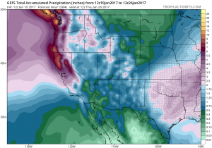
I’ll keep this section short: after another weak to moderate (and colder) system on Wednesday/Thursday (which could bring snow to the foothills and isolated thunderstorms elsewhere, including Southern California), things should dry out for 3-5 days. This will allow rivers to recede and soils to drain a bit. But both the GFS and ECMWF suggest that an active pattern over the North Pacific may redevelop by next week. Stay tuned!
For updates on today’s storm, follow Weather West on Twitter!
Discover more from Weather West
Subscribe to get the latest posts sent to your email.