Recent weather summary
The weather in California has been relatively uneventful over the past few weeks. Periodic thunderstorm activity has continued to affect mainly inland desert and mountain areas, mostly in the southern part of the state.
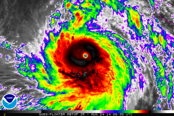
Hurricane Marie–once a formidable category five storm in the eastern Pacific ocean–brought pretty clouds (but also damaging surf conditions) to much of the state this past week. While there had been preliminary indications in forecast models that a substantial amount of Marie’s remnant moisture and perhaps even the storm’s former center of circulation might be steered toward California, perhaps bringing some rare summer rains, that solution has (obviously and unfortunately) not come to pass. Near-shore sea surface temperatures remain extremely warm, with buoys off the coast of the San Francisco Bay Area repeatedly registering all-time record high ocean temperatures. These very warm temperatures have resulted primarily from greatly reduced cool water upwelling near the California Current, which itself stems from suppressed northwesterly winds caused by persistent atmospheric ridging. It’s also possible that there has been some contribution by so-called “coastally-trapped” Kelvin waves, triggered by the massive equatorial Kelvin wave that occurred in the tropical Pacific earlier this year.
Drought update
I’ll keep this short: California’s still experiencing extreme, record-breaking drought conditions. Impacts continue to become more widely felt–and have recently started receiving considerably more media attention. Reservoir levels are still dropping rapidly, and will continue to do so for at least another 2-3 months.
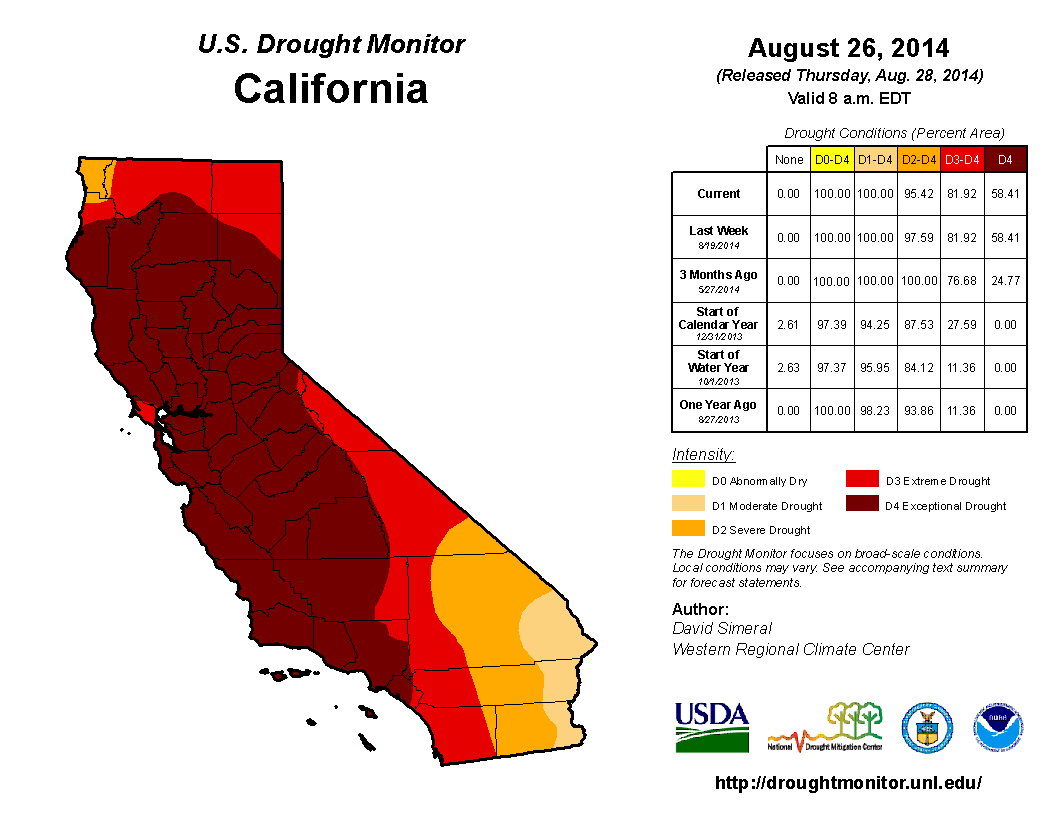
While nearly all major reservoirs are still above the record-low levels set during the 1976-1977 and 1987-1992 droughts (largely due to water management decisions made this year), a number of reservoirs stand a good chance of dropping below these previous record lows during October/November 2014. The Drought Monitor, unsurprisingly, continues to suggest that a very large fraction of California is experiencing exceptional drought–the most intense categorization.
An update on the fire season
California’s wildfire season has thus far been very active–with numerous fires throughout most parts of the state. None of these, however, (with the major exception of the unusual San Diego area fires back in May) have been especially damaging to human infrastructure despite burning considerable forest/wildland acreage. Why has this been? Well, despite the fact that fuels are explosively dry in most areas due to the drought, there have been relatively few strong wind and/or dry lightning events thus far this dry season. One or both of these ingredients is typically needed for a really serious wildfire outbreak in California, even when the background fire risk is very high. In other words: we’ve gotten very lucky so far, given the state of the forests this year.
It’s not clear that this luck will hold out until the rainy season starts, though. The late summer and fall months are “Santa Ana” season in California–in other words, the likelihood of extremely dry and strong offshore wind events increases dramatically during September-October. As “inside slider” low pressure systems plunge southward to the east of California over the Great Basin in the lead-up to winter, strong surface pressure gradients often develop during this period, bringing late-season offshore winds and heat waves near the coast. These offshore winds (and the subsequent suppression of the marine layer) is the primary reason why summer-like conditions in California linger for 1-2 months longer than in most other locations in North America. Thus, we’re definitely not out of the woods yet. Historically, many of California’s very large and damaging fire have occurred during Santa Ana season, and with drought-cured fuels the potential for dangerous fire conditions is still much enhanced until the arrival of wetting rains eventually this winter.
An update on El Niño
Reports of El Niño’s demise have been…greatly exaggerated. While Niño region sea surface temperatures (SSTs) did decrease notably in the wake of the big Kelvin wave earlier this year, they’re on the increase once again. A new Kelvin wave is currently propagating across the Pacific, and is expected to arrive along the shores of South America in a few weeks.
This wave is not nearly as strong as the one earlier this year, but it should be enough to formally establish El Niño-like SST anomalies by the fall months. Nearly all major dynamical and statistical model guidance still suggests the likely development of El Niño conditions by the fall, though a strong event now appears to be unlikely (most likely: weak to moderate strength). This does have implications for conditions in California, since historically only strong El Niños have consistently been linked to above-normal precipitation in the state (this is especially in the north, where much of the water storage capacity resides). Thus, it does not currently appear that a strong El Niño will bring drought relief to California this winter. On the other hand, as I’ll discuss further below, this does not necessarily mean that California is in for a dry winter.
A quick primer on the onset of the rainy season in California
Most readers who actually live in California are already very familiar with the fact that California has a very well-defined rainy season, typically encompassing the consecutive months from November to April (and sometimes as early as October and as late as May). While there is considerable variability from year to year, the existence of a pronounced seasonal cycle allows for the construction of a pretty reliable theoretical model for rainy season onset, which I’ve tried to capture in the composite maps (presented as animated GIF images) in this section.
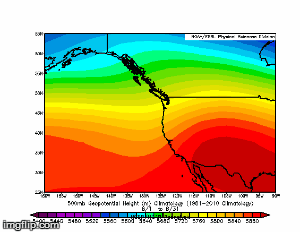
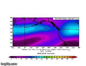
The typical progression is as follows: the mean trough over the West Coast during the summer months gradually transitions into a mean relative ridge as the Northern Hemisphere storm tracks become active and deep mean troughs form to the west of California (in the Gulf of Alaska) and to the east (over interior North America). At the same time, upper-level westerly winds (i.e. the jet stream) begin to strengthen and shift southward over the North Pacific Ocean, eventually extending further east toward the West Coast as winter deepens.
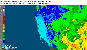
These “average” conditions don’t tell the whole story, though, since these time-averaged values don’t show the occasional deep troughs and storm systems driven by the strong and eastward-extended Pacific jet stream that bring most of California’s cool-season precipitation. The seasonal cycle of precipitation shows this evolution more clearly, with precipitation increasing rapidly from north to south during October and November and peaking in most places sometime during January-March. The most remarkable part of the ongoing drought–and the associated “Ridiculously Resilient Ridge” pattern–is that this well-defined seasonal cycle was completely disrupted. But that’s a story for an upcoming post…
What can we say about the coming winter? Is drought relief on the horizon?
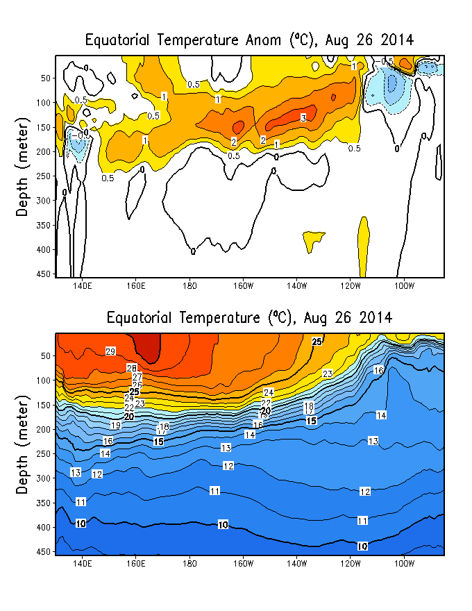
As I noted above: a strong El Niño–which might have been a meaningful predictor for a wet winter to come–now appears very unlikely. But why, exactly, is El Niño so important in the first place? As I’ve previously discussed, El Niño affects California weather in several direct and indirect ways, but the primary mechanism during the cool season arises from the re-arrangement of of SSTs in the Pacific Oceans and subsequents effects upon the storm track. Because it’s the spatial patterns of ocean temperatures–the actual distribution of warm vs. cool conditions–which can affect large-scale atmospheric conditions by reorganizing atmospheric temperature differences, it’s worth looking at expected pattern of SST anomalies for the coming winter. Others have recently noted that the current phase Pacific Decadal Oscillation–which has been negative for most of the past 15 years or so–has recently flipped into positive territory.
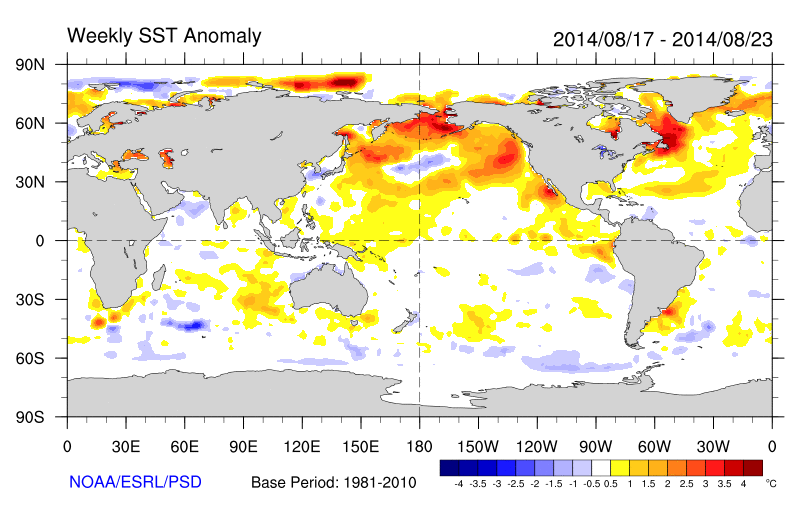
The spatial patterns of SST that define the positive phase of the PDO are generally favorable for increased cool-season precipitation in California. A number of dynamical forecast models suggests a continuation of +PDO conditions through the heart of the upcoming wet season. This does not, however, necessarily mean that California is in for a wet winter. First: despite the current +PDO signal, SST patterns in the North Pacific are pretty unusual from a historical perspective: the big “blob” of very warm water in the far northeastern Pacific remains, and is expected to decrease rather slowly over the next few months. The entire North Pacific is currently quite warm, which means that atmospheric “teleconnections” may be different from those that have been observed historically during +PDO years. Second, there are some indications that the still-developing weak-to-moderate El Niño could turn out to be a mid-Pacific centered event (a so-called “El Niño Modoki”), which might act to enhance the storm track well to the west of California, rather than closer to the coast (where it would be more likely to enhance precipitation).
What do the dynamical models say? Well, I preface the following discussion with a big caveat: seasonal climate prediction is still subject to very large uncertainties, and in many locations is not much better than a random guess based on historical average conditions (in technical terms, these forecasts often have “little to no skill relative to climatology”). Indeed: it turns out that few dynamical models make skillful precipitation projections during California’s “wing seasons”–that is, during the fall and spring months, which are the seasons during which precipitation varies the most from year to year.
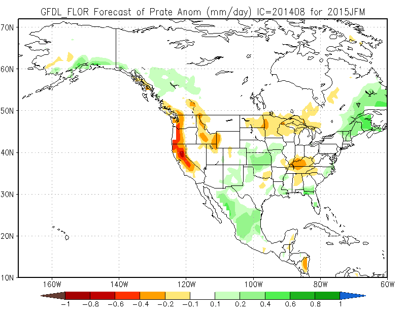
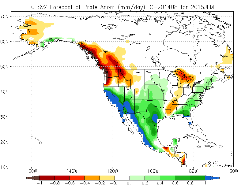
Most models do have modest skill during the “core” wet months, though, from January through March. None of the major dynamical models are currently projecting a wet fall, so it appears that the likeliest outcome for the early part of the rainy season is near or below average precipitation. Later this winter, however, all bets are off. Some of the most skillful dynamical models have been hinting at the possibility of a rather wet period during January and February, which appears to be a response to the +PDO-like SST configuration in the Pacific. What’s interesting, though, is that while a handful of models are suggesting very wet conditions during the core months of the rainy season, others are projecting exactly the opposite: unusually dry conditions during January-March. Given the relatively low forecast skill exhibited by all of these models, it’s not clear which of these outcomes is more likely given the complex evolution of events in the Pacific Ocean over the past couple of years and the potentially competing influences of a +PDO signal and El Niño Modoki-like SSTs.
What’s the overall message here? Right now, there aren’t any clear precipitation signals for the upcoming winter. However, it does appear that near or below-average precipitation is the most likely outcome for the fall months, while there are nearly equal chances of above or below normal precipitation later this winter. Because there is no obvious drought relief on the horizon, it would be wise to prepare for another dry year. Stay tuned.
© 2014 WEATHER WEST
Discover more from Weather West
Subscribe to get the latest posts sent to your email.