Overview of recent weather conditions
April and May were very dry months for much of California. In most of the major population centers, little or no measurable precipitation occurred during the entire month of May.
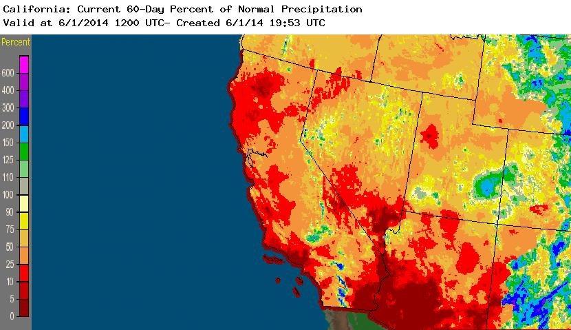
Occasional thunderstorms did bring highly localized downpours –mostly confined to the Sierra Nevada mountains–but overall precipitation was well below average for both April and May. Now that June has arrived and there’s still no rain on the horizon, I think it’s pretty safe to say that the incredibly dry 2013-2014 “rainy” season is over.
Warmest year on record to date
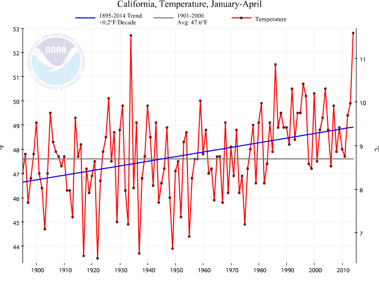
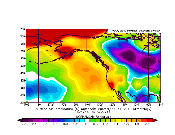
In addition to the exceptionally dry conditions, temperatures in California have consistently been at their highest levels in recorded history for at least the past 6 months. NOAA previously confirmed that California experienced its warmest winter in at least 119 years of record-keeping, and more recent data suggests that 2014 is now the warmest year to date. In addition to the anomalous warmth on the multi-month scale, California was also been subjected to several intense, early-season heatwaves during April and May. All-time monthly high temperature records were set in a number of locations, particularly in Southern California–and more than a few stations set records for the earliest 100-degree day on record. What made these heat waves even more unusual was that they coincided with very strong offshore Santa Ana wind events. While this setup wouldn’t have been particularly notable if it had occurred in the fall months, such extreme fire weather conditions are virtually unheard-of in the spring months. Destructive, fast-moving wildfires did occur, and their intensity was such that multiple “fire whirls” were reported (and, even more impressively, caught on camera).
Why has it been so warm and dry in California?
Over the past year, I’ve repeatedly discussed the persistent large-scale atmospheric pattern that has led to the ongoing extreme drought in California.
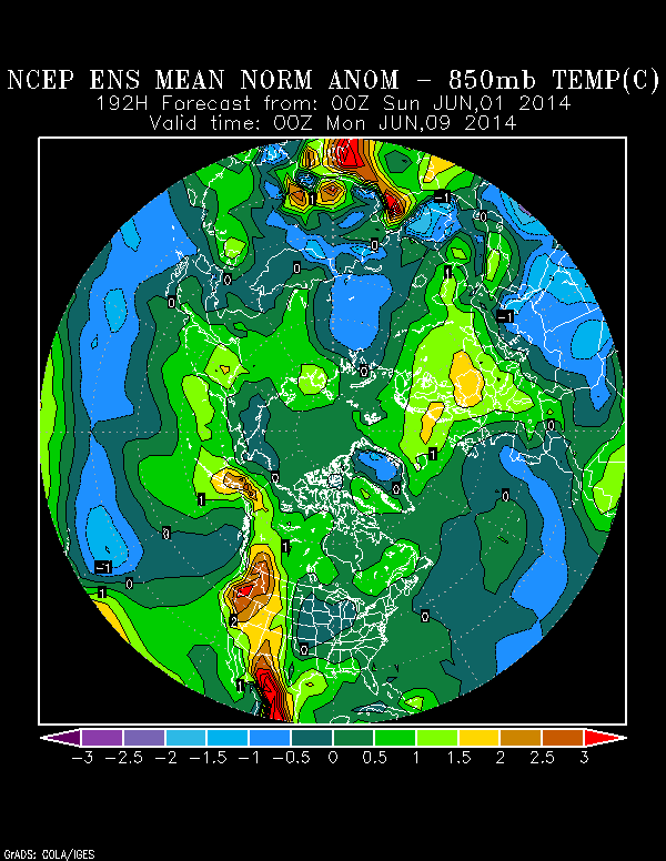
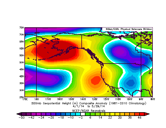
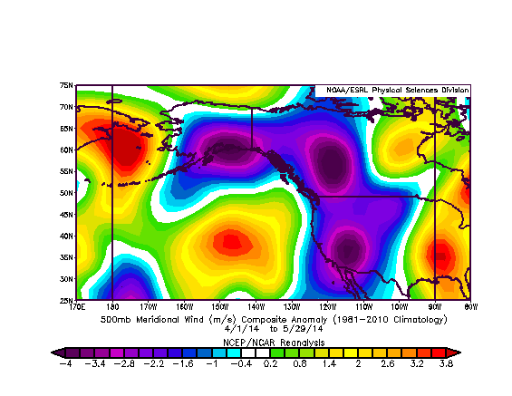
An extraordinarily persistent area of high pressure over the northeastern Pacific Ocean deflected storm track well to the north of its typical position for much of the previous two winter seasons. While the prevailing high-amplitude flow pattern was finally interrupted by some storm activity in February and March–a period which brought the only substantial, widespread precipitation California has seen in over 18 months–our friend the Ridiculously Resilient Ridge staged something of a comeback during the spring months. While the magnitude of middle-atmospheric height anomalies is not as large as it was during the peak of the RRR back in January 2014, the familiar pattern of strong poleward flow over the Pacific and strong equatorward flow over the interior Western United States remains distinct. Unfortunately, the current pattern remains favorable for continued above-normal temperatures during the early part of summer.
Just how dry is it in California?
As previously mentioned, precipitation during February and March did help to generate a very modest Sierra Nevada snowpack and generate some much-needed runoff in Northern California reservoirs.
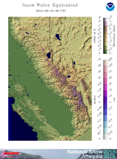
However, due the meager water equivalent stored in the Sierra snowpack at its peak and the very early onset of melting due to the heat waves in April and May, there is effectively no snow left as of this writing on June 1st. This is likely to have two notable short-term consequences: 1. soil and vegetation moisture in the mountains will be extremely low for a much longer period of time than usual this year, leading to increased wildfire risk, and 2. reservoir drawdown has already begun a month or two ahead of schedule. Given that maximum storage levels this winter/spring where already very low, it appears likely that a number of reservoirs may once again approach critically low levels by the end of the dry season in September or October. As others have already remarked: it’s going to be a long, dry summer.
In my next post, I’ll have an update on the El Niño event still developing in the equatorial Pacific Ocean.
© 2014 WEATHER WEST
Discover more from Weather West
Subscribe to get the latest posts sent to your email.