Summary of Recent Weather Conditions
California’s meager rainy season of 2013-2014 experienced its last gasp in late April. Modest rainfall (and mountain snowfall) occurred on April 25th, though outside of a few localized downpours overall precipitation totals were not particularly noteworthy. Over the past ten days, strong high pressure associated with a high-amplitude 500mb ridge developed over the far Eastern Pacific, bringing a record-breaking early-season heat wave to much of California.
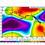
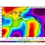
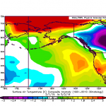
A number of daily high temperature records were set over a multi-day period over a geographic region spanning the far North Coast (near Eureka/Arcata) to the Mexican border (including San Diego County). Remarkably, the afternoon high temperature recorded at the San Francisco Airport on April 30th was higher than any recorded temperature during all of calendar year 2013! This spring heatwave also coincided with the occurrence of powerful Santa Ana (offshore) winds in Southern California, with the typically windier mountain peaks seeing gusts in the ~100 mph range. These high winds–combined with ongoing extreme drought conditions–led to extreme fire weather conditions, and several wildfires did ultimately break out. In the wake of this heatwave, the Sierra Nevada snowpack fell further from near-record low levels to essential nonexistence.
It’s interesting to note that the observed large-scale atmospheric pattern over the Eastern Pacific since March has featured a return to increasingly persistent anomalous ridging. While an incursion of the Pacific jet did effectively knock down the Ridiculously Resilient Ridge in early February–allowing a series of significant storm systems to bring much-needed precipitation to California–California has found itself either directly underneath or immediately downstream of a fairly persistent region of positive geopotential height anomalies since early March. While there were a couple of significant precipitation events during that interval (which did not occur during the RRR’s reign), high pressure and well-above-average temperatures have dominated California’s weather over the past couple of months.
The forecast: more of the same
Unfortunately (though perhaps not surprisingly), dry weather will remain the rule over the next 1-2 weeks. A few showers and perhaps even an isolated thunderstorm (mainly in the mountains) will be possible late Monday into Tuesday as a weak system brushed California, but widespread precipitation is not expected and anything that does fall will be light. 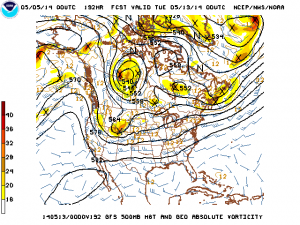 This system will bring another round of strong offshore winds to Southern California, though they will probably not be quite as strong as the most recent (damaging) episode. Temperature will warm again later in the week as high pressure rebuilds and a new ridge forms along the West Coast. In short: anyone hoping for a late-season soaker is out of luck.
El Niño update: still appears likely that we’re in for a big one
I’ve been closely following the evolution toward an El Niño event in the Pacific Ocean for several months. Early interest in this event was piqued by the initiation and eastward propagation of an enormous oceanic Kelvin wave earlier this winter, which has since traversed the entire Pacific basin and reached the west coast of South America. Large positive subsurface temperature anomalies associated with this Kelvin wave are now surfacing in this region, and in recent days there has been a rapid rise in sea surface temperature (SST) anomalies.
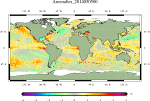
A number of anomalous westerly wind bursts (WWBs, or disruptions to the prevailing easterly trade winds) have been observed in the West Pacific, while a more modest (but steady) weakening of the Easterlies has been observed in the East Pacific. Patterns of equatorial convection (tropical thunderstorm activity) have shifted in a way that suggests that the atmosphere is starting to respond to these changes in SSTs, meaning that the self-reinforcing physical patterns associated with a developing El Niño appear to be well underway. Notably, a new Kelvin wave appears to be forming in the West Pacific in response to the strong WWBs earlier this year, which is likely to send another pulse of warm water eastward over the next 1-2 months.
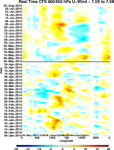
In the relatively short term, numerical models suggest that a fairly strong WWB will occur this week much further east than as yet been observed during the current event.This is a potentially important event in the evolution of El Niño, since this temporary 180-degree reversal of the winds in the Niño 3.4 region will essentially shut down whatever weak upwelling remains in the far eastern Pacific. If this event comes to pass as currently projected in the models, I’d expect rapid SST warming to continue and expand westward over the next 2 weeks. With additional major West Pacific WWBs slated for early summer, wind conditions appear to be favorable for the maintenance of the already-developing second major Kelvin wave and perhaps even the formation of a third later this summer. There is currently no evidence of a sub-surface cool pool developing in the West Pacific after the passage of the huge Kelvin wave a couple of months ago, which effectively means that there’s no obvious “kill switch” that would have the potential to shut down this developing El Niño event before it really gets going. In other words: a repeat of summer 2012–where early-season signs of a developing event ultimately collapsed, leading to failed forecasts and much consternation–appears to be very unlikely.
How does 2014 stack up to 1997 (so far)?
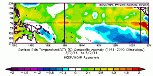
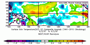
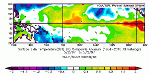
Many comparisons have been made between the presently developing event and the lead-up to the powerful 1997-1998 El Niño event. These discussions have centered largely upon the fact that the observed magnitude of the Kelvin wave now surfacing in the East Pacific is comparable to (or even greater than) a similar wave that occurred during late winter 1997. New data now suggest that the observed evolution of sea surface temperatures is now also remarkably similar to 1997, although as can be seen in the below plots 2014 is tracking several weeks behind 1997. The structural similarity of SST anomalies in the equatorial Pacific between 1997 and 2014–combined with numerical model projections for continued warming in the coming months–suggest that the it’s still rather likely that the Pacific is headed for a major El Niño event this year. By the end of May, we start to move past the Spring Predictability Barrier, so I expect that we’ll have a much better handle on where things are headed by early June. Stay tuned!
© 2014 WEATHER WEST
Discover more from Weather West
Subscribe to get the latest posts sent to your email.