Drought update
A notable amount of late-season precipitation fell throughout much of California during late March and early April. Given how dry winter 2013-2014 has been overall, this early-spring rain and snowfall–while not heavy by the standards of a more typical winter–represents a substantial fraction of all the precipitation that accumulated during the current Water Year.

This recent precipitation has been effective in mitigating some of the very short-term impacts of the ongoing drought in California–adding moisture to the soil surface (and subsequently reducing extreme water stress on vegetation and temporarily decreasing wildfire risk) and resulting in modest flows into most of California’s major reservoirs.
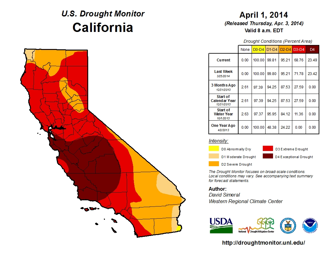
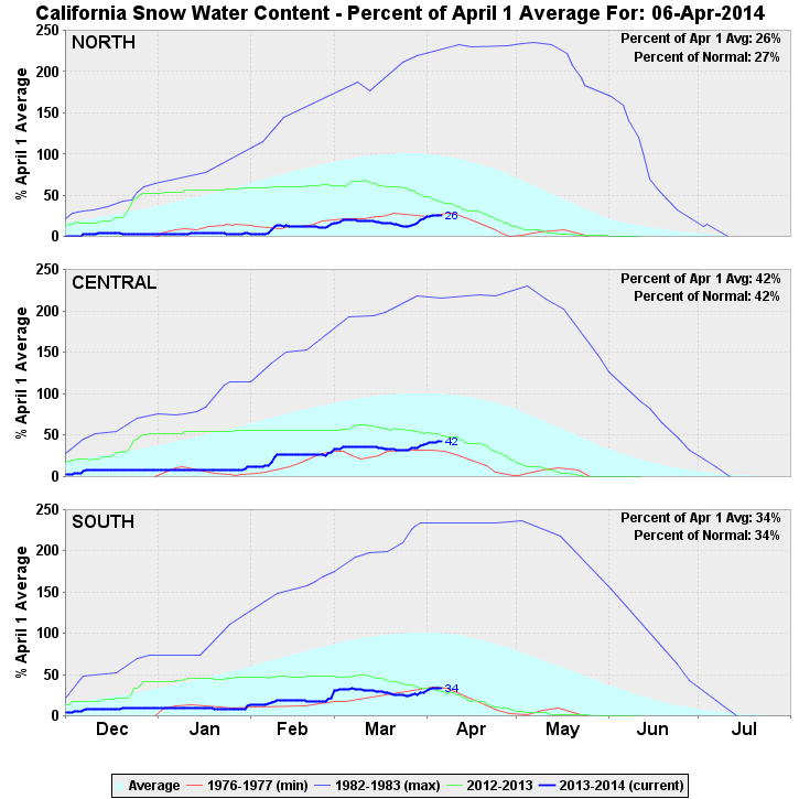
This is certainly good news–and the hillsides certainly look greener than they did a couple of months ago. But just how much long-term relief has California experienced from its record-breaking drought? Well, the answer is: not much. Most of California is still below 50% of average for this time of year, and there’s no precipitation on the horizon for the next 1-2 weeks. This suggests that the 2013-2014 rainy season is over, for all intents and purposes, and that the existing tremendous rain and snowfall deficits are effectively “locked in” until next winter. Sierra snow water equivalent–despite receiving a considerable boost during recent storms–is still at or near record low values in the north and south (although the Central Sierra is now tracking marginally above the record low values observed during the extremely dry ’76-’77 water year). Water storage in California’s reservoirs is higher than earlier this winter, but spring runoff will be exceptionally low over the next 1-3 months and I would expect to see very low water levels again by mid-summer. In short–we’re still in the midst of an extreme drought in California, despite recent precipitation. The intensity of the drought is slightly less than observed during November 2013-January 2014, but there’s little doubt that California remains extraordinarily dry.
Short-term outlook

One word could be used to describe expected conditions across California over the next 1-2+ weeks: summer-like. Very warm daytime temperatures will occur across most of the state for the upcoming week, with a cool down to merely slightly above-normal values by the coming weekend. Unfortunately, no additional precipitation is on the horizon as strong high pressure rebuilds over the Eastern Pacific (though that’s no longer especially unusual, given the time of year).
El Nino conditions developing rapidly in Tropical Pacific
There has been much discussion and speculation regarding the recent observed and expected near-future developments in the tropical Pacific Ocean. Here’s a quick summary of what we know so far:
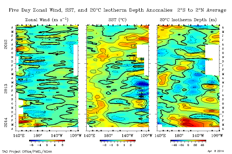
- Large sub-surface temperature anomalies have been observed in the equatorial Pacific Ocean in association with very strong equatorial Kelvin wave activity over the past 2-3 months
- Positive sea surface temperature (SST) anomalies have begun to surface in the central and eastern Pacific over the past 1-3 weeks
- Westerly wind bursts (WWBs) have been observed with increasing frequency and intensity over the western and central Pacific over the past 2 months
- Current conditions strongly resemble those observed in the lead-up to the powerful 1997-1998 El Nino event
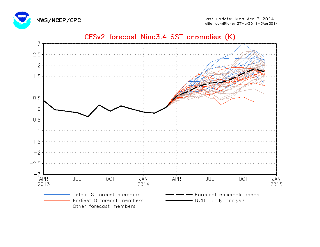
- Recent projections from coupled atmosphere-ocean models strongly support the continued development of significant El Nino conditions over the next 1-3 months

An exceptionally strong oceanic Kelvin wave (KW)–the most intense since at least 1997–is currently making its way eastward across the equatorial Pacific Ocean. Upwelling associated with the this KW has resulted in rapidly-warming SSTs as very large sub-surface temperature anomalies (on the order of 6-7+ C) rise toward the ocean surface. At the same time, easterly trade winds have begun to weaken across almost the entire Pacific basin, punctuated by distinct WWBs that have thus far been focused in the western and central Pacific. This increasingly anomalous wind pattern suggests that the atmosphere is already starting to respond to the warm ocean conditions, which is a crucial step in the development of a full-blown El Nino event.
While I won’t delve too deeply into the physics of ENSO in the present post (others have recently done an excellent job), it’s worth emphasizing the importance of positive (self-reinforcing) feedbacks in the coupled ocean-atmosphere system. Warm East Pacific SSTs favor a continued weakening of the easterly trade winds, which leads to further SST warming; unusually high West Pacific SSTs favor enhanced tropical cyclogenesis and associated westerly wind bursts, which beget even warmer ocean conditions. The fact that these feedback processes now appear to be ramping up in the presence of record-high sub-subsurface temperature anomalies highlights the potential for a very significant El Nino event to evolve over the next several months. Forecasts from dynamical atmosphere-ocean models have recently become much more bullish regarding prospects for a strong El Nino event–and NCEP’s CFS model ensemble is now explicitly projecting that very strong El Nino conditions will be in place by November. A handful of ensemble members now project an event even stronger than the exceptional 1997-1998 El Nino. The high values foreseen by the upper-end ensemble members are especially remarkable given that the models used to predict ENSO typically underestimate the magnitude of extreme events. At the same time, however, we’re still on the wrong side of the so-called “spring predictability barrier”–which is another way of saying that our confidence in numerical model projections from early April is still low relative to the confidence we’ll have in model projections just a month or two from now. What is clear at this point is that all signs continue to point toward the rapid development of a strong El Nino event.

In a future post, I’ll discuss in much greater depth what the potential impacts of a powerful El Nino event might be in California. There are presently indications that California may experience impacts as early as the coming summer–including the possibility of unusually warm temperatures and perhaps even some very unusual warm-season precipitation events. The million-dollar question, however, is what effects El Nino might have on precipitation during the 2014-2015 rainy season. For now, I’ll say this: next winter has the potential to be very different indeed than the exceptionally dry one we just experienced.
© 2014 WEATHER WEST
Discover more from Weather West
Subscribe to get the latest posts sent to your email.