Spring has sprung (finally) in California, and with warmer temperature, major snowmelt flooding looms. Plus: El Niño is rapidly developing…
Yet another extraordinary period of California weather
Well, things are finally calming down, weather-wise, in California after a rather extraordinary season. And March, in some ways, put an exclamation point on this very active period: it ended up being the coldest March on record in some parts of NorCal, and well colder than average almost everywhere else in CA. That is a truly remarkable statement, especially since the sustained centennial-scale warming trend in California has made it very difficult to experience long durations of record-breaking cold temperatures in recent decades. This very cold March has major implications for agriculture in California, and have also been part of the reason why the enormous Sierra snowpack has only just begun to melt as temperatures finally start to warm in early April.
This winter overall also ended up being the coldest in ~44 years in a statewide basis–meaning that no one born after 1979 has ever experienced a season this cold in California! And, yet, winters as cold as this one used to be relatively common prior to the 1970s, which is a dramatic testament to just how large and sustained California’s long-term warming trend has actually been and how rare record-breaking cold is today.
This winter was, of course, also exceptionally wet across portions of California. Although this year has not turned out to be among the wettest on record on a statewide basis–since far NorCal actually saw near-average precipitation–it was indeed the wettest on record across central portions of the state stretching from the Central Valley into the southern and central Sierra Nevada. This means that around two thirds of California has now experienced a “record wettest” winter at some point in the past decade–and nearly all of California has also experienced a “record driest” winter during the same period (and in some cases, more than once)!
Spring warmth and calmer weather have finally arrived, with a more typical pattern expected in coming days
A fairly typical spring pattern will likely take shape in the coming days and weeks across California–which will feel pretty warm and calm in comparison to recent months. I expect the overall North Pacific/West Coast flow pattern to be “progressive” in nature, with occasional weak spring-like systems passing through but no major or sustained precipitation events. It’s likely that the higher mountains will still see at least one or two minor additional snow events over the next couple of weeks, but not enough to offset the substantial snowpack melting that will likely occur as the strong spring sun and warmer temperatures start to work their magic. Lower elevation areas may see occasional shower chances, mainly in NorCal, but precipitation should remain near average in NorCal for April and probably below average in SoCal (and averages start to sharply decrease this time of year).
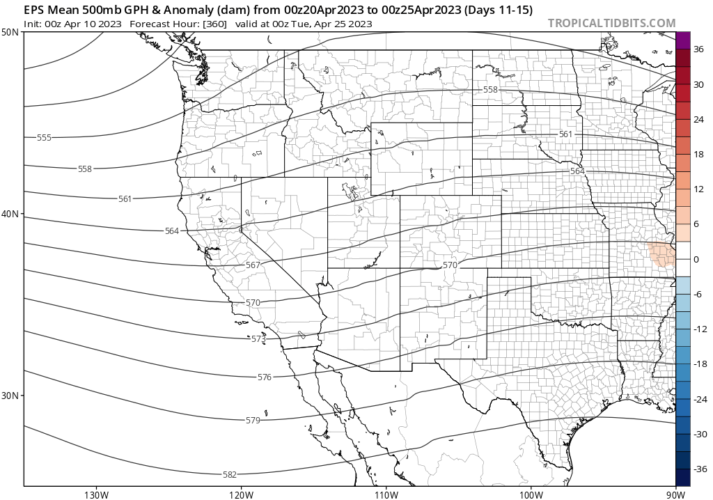
Temperature-wise, conditions will likely oscillate between slightly cooler and slightly warmer than average over the next couple of weeks. The ensemble mean 500mb flow pattern for this period is “remarkably unremarkable”–with no sustained anomalies of either sign apparent. The cold nearshore ocean waters, plus the still-extensive Sierra snowpack, may exert a slight additional local cooling effect in relevant areas, too. All in all, this looks like a fairly benign weather pattern–and will allow the enormous snowpack to finally start melting more quickly (but not too quickly…for now).
Spring and early summer snowmelt flood risk looms large in/below Southern Sierra watersheds
Although no extreme snowmelt events are currently on the horizon for the next 1-2 weeks, there is still a record-breaking amount of snow water that’s going to have to come downhill at some point between now and mid-summer. We still can’t rule out a late season (late April or May) warm atmospheric river (happens every few years), and once we get into May significant heatwaves become significantly more likely. There will probably be, at some point, a significantly larger pulse of meltwater both on the watersheds draining into the Tulare Basin and southern San Joaquin watershed as well as the Owens Valley and east slope watersheds at some point between now and mid-June, but it’s still impossible to say exactly when that’s going to occur. Widespread flooding is inevitable (and already ongoing) in the Tulare Basin, and will likely get worse before it gets better. Flooding of some magnitude is also likely farther north in the San Joaquin watershed and in the Owens Valley, though just how bad things get there (minor-moderate vs. severe) will depend on whether there are any especially intense snowmelt pulses. Additionally, there is concern regarding prolonged high flow/stress on flood protection levees and the potential for eventual failures even if there are no record-breaking runoff events this spring (simply because these structures will be subjected to high stress for weeks to months on end). This will continue to be a major story in the coming weeks even as the rest of the state dries out and recovers from this winter’s damaging and disruptive events–flood risk may linger into mid-summer in some areas subject to direct snowmelt runoff.
It’s also important to note that this season has been an excellent snow accumulation period for much of the Lower Colorado River Basin–and it couldn’t have come at a better moment in the context of the extreme multi-decadal “megadrought”. One wet and cool winter does not, of course, obviate a 2-3 decade long drought–but this year will at least partially de-fuse the short term crisis that had escalated (as recently as autumn 2022) to crisis levels. Snowmelt runoff into the big CO River reservoirs in the coming months will stave off worst-case scenarios for at least a year or so, giving a little breathing room to figure of what to do in the context of the long-term sustainability crisis amid a warming climate.
El Niño update: it’s coming.
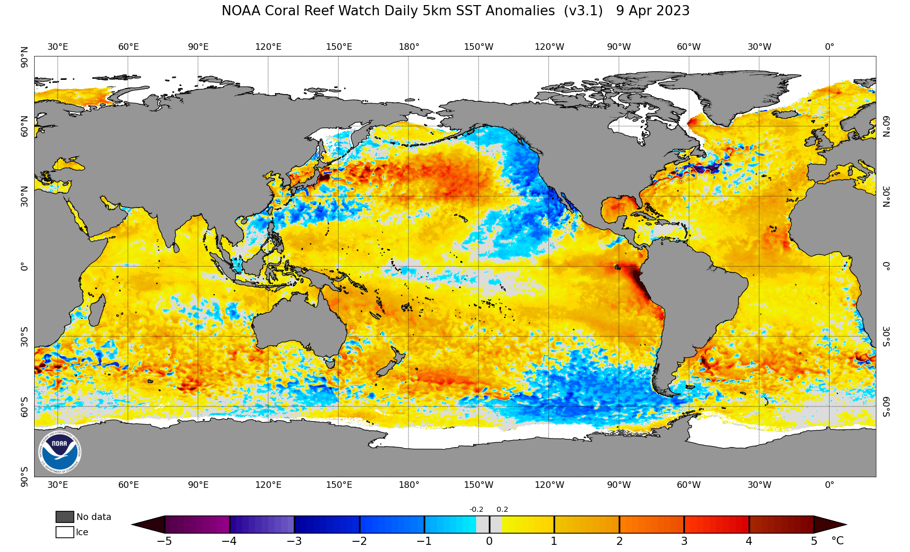
At this moment in time, no person alive has ever experienced global ocean temperatures as warm as they are today (i.e., the global average SST anomaly has reached record levels in recent days). This is despite remarkably cool patches of water in two regions: the sub-Antarctic eastern Pacific west of South America, and the mid-latitude East Pacific along the coast of western North America (including along the California coast). Nearly everywhere else on Earth, the oceans are presently much warmer than the long-term average–and this is especially true near the west coast of tropical South America near Peru, where SST anomalies are locally in excess of 5C (9F). That is an extraordinary level of oceanic warmth, and is highly suggestive of the early stages of a significant El Niño event.
And indeed: all other indicators also point to a rapidly-developing El Niño in the tropical Pacific. Westerly wind bursts are underway; subsurface warm water is sloshing eastward; and both dynamical models and statistical predictions suggest a very high likelihood of transitioning into El Niño conditions by this summer or autumn at the latest. In fact, dynamical model predictions continue to become more and more aggressive regarding the potential magnitude of the coming El Niño event–with some indicating at least some possibility of a “super El Niño” by next autumn (i.e., one comparable to or greater than the top-tier events that occurred in 82-83, 97-98, and 15-16).
Despite much hype at the moment, it’s important to remember that we do remain on the “wrong side” of the “Spring Predictability Barrier” (during which models sometimes struggle to produce reasonable predictions of what might happen in the coming months). I normally wouldn’t put too much stock into explicit ENSO intensity predictions at this early juncture. However, in this case, there are plenty of ocean-atmospheric dynamical theories that would suggest that the path toward a significant El Niño event is indeed plausible this year–especially all the energy stored in the tropical Pacific Ocean during the remarkable “Triple Dip” (three year long) La Niña event that just ended. So for now, it remains a waiting game…but I do think it’s increasingly likely this will be a major player in California weather starting later this summer and into next autumn/winter. Stay tuned.