Much warmer conditions and mountain thunderstorms return to CA as extreme blocking pattern develops over western Canada
Another active and unusually cool period in early May across CA
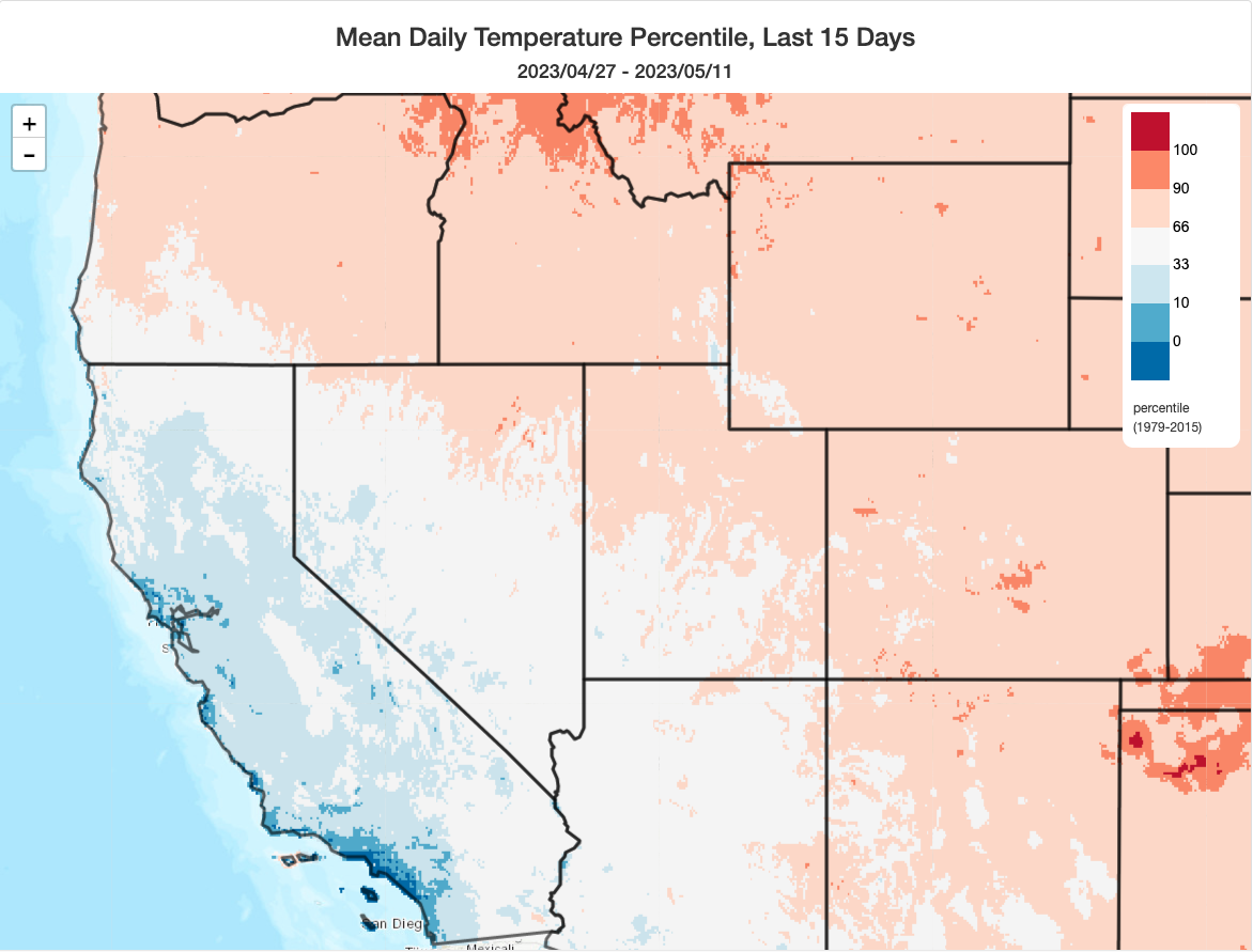
After The Big Melt got a big boost from a short but sharp early-season heatwave, conditions in California once again cooled to below average temperatures as yet another late-season storm system brought more rain to lower elevations, a few severe thunderstorms (and another weak tornado or two in the LA Basin), and high mountain snow accumulation. Mountain snowmelt, unsurprisingly, slowed down again amid cooler conditions (but still maintained a high baseline). But that cool and unsettled pattern is once again in the rear-view mirror, as a much warmer pattern is imminent.
As blocking ridge develops over western Canada, anomalous combination of spring heat + moisture in CA
The upcoming significant and fairly prolonged warming trend in California is actually going to be a pretty strange one by mid-spring standards. The ridge isn’t going to be centered over CA, or to the southeast of CA–instead, an extreme blocking ridge is expected to set up residence over Western Canada, inducing anomalous southeasterly flow over California and bringing a warm (and somewhat moist and unstable) period. The extraordinary ridge over British Columbia and Alberta will likely break many May monthly and spring seasonal 500mb GPH and surface temperature records, and will very likely further exacerbate the already serious forest fire situation that has unfolded in that region in recent days. This setup does seem eerily familiar–it’s rather strikingly similar, from a synoptic meteorology perspective, to the June 2021 pattern that brought record-shattering heat and extreme societal impacts to the Pacific Northwest (and became the single deadliest weather event in Canadian history).
Now, to be very clear: I do NOT expect this event to bring absolute temperatures nearly as hot as occurred in June 2021 (especially on the U.S. side of the border, but also on the Canadian side). Why? Well, although the ridge is projected to be *almost* as anomalous, in a relative sense, as the June 2021 event, it does look a little weaker. And, more importantly, it’s much earlier in the year–mid May vs late June–and it’s centered a few hundred miles further north. Background temperatures are simply lower due to the earlier date and the more northward epicenter, so there won’t be any 115 degree temperatures in Portland or 120+ in the glacial valleys of B.C. with this one (fortunately). However, I do nonetheless expect impacts from a fire weather and snowmelt perspective to be extreme up in interior BC and AB.
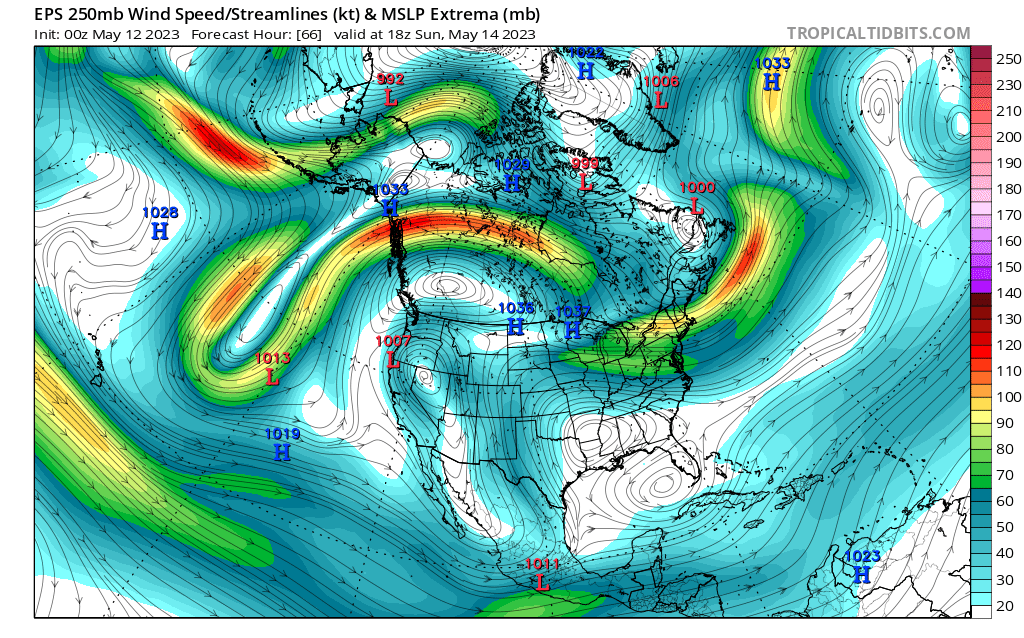
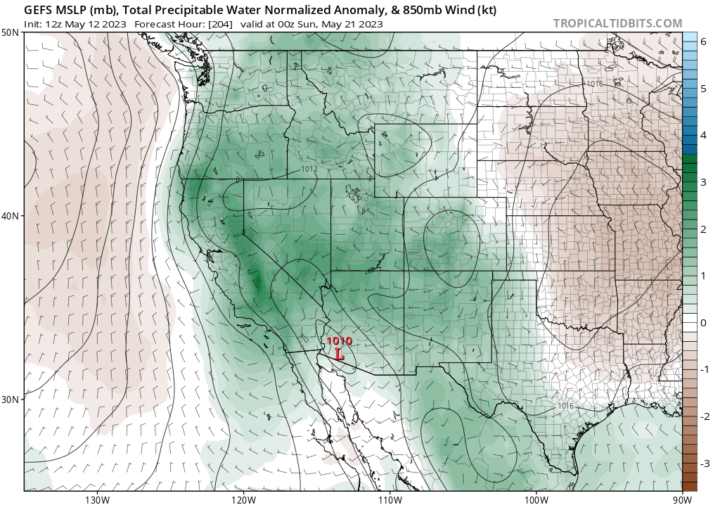
What does this mean for California? Well, the persistent blocking ridge is going to profoundly disrupt the jet stream, causing it to take a tortuous path poleward well off the West Coast. A weak upper-level low will develop under the ridge, centered over the Great Basin, and retrograde westward. This will bring an unusually warm and somewhat moist and unstable airmass across much of the West for an extended (7-10+ day) period. In California, temperatures will warm to well above seasonal averages for mid-May (though probably not to extreme levels) and stay there for a while. This will be a relatively humid airmass, as mentioned above, that may also support some pretty robust mountain thunderstorm activity (and not just in the Sierra, but also more widely distributed across the higher terrain of CA and adjacent states). There’s even a *slight* chance of somewhat more widespread thunderstorms if a weak disturbance can support elevated convection over the CA interior at some point, but the odds of that appear low (but non-zero) at this point. If this sounds reminiscent of a monsoon-like pattern, you wouldn’t be mistaken! BUT…this isn’t the monsoon, as is it’s not being driven by a semi-permanent seasonal reversal of large-scale wind patterns over the Desert Southwest. So it’s essentially a “monsoon impostor” pattern–which is still highly unusual for May.
El Niño predictions continue to escalate; strong event now more likely than not by fall
El Niño continues to rapidly develop, and now essentially every observed oceanic and atmospheric indicator is consistent with predictive model forecasts showing a very high likelihood of El Niño thresholds being exceeded by autumn. In fact, there is now officially a >50% chance of a strong El Niño event by late autumn–and I personally suspect the odds are even higher than that. The high prospects of a strong ENSO event, in particular, are what give some indication this event is likely to exert a significant influence on CA weather by late summer or autumn and continuing into winter. I’ll discuss the details more later, but suffice it to say for now that everything currently appears to be on track for a major event.
Introducing: the Extreme Weather and Climate Calendar by…yours truly!
I suspect this will be of interest to many avid Weather West readers (and hopefully others, too!): my new Extreme Weather and Climate calendar (published by Workman Publishing) is now available for pre-order! The 2024 calendar will become available later this summer, and I’m wrapping up a 2025 calendar now. There’s fascinating and unusual weather and climate trivia, of course, but I’ve also worked to distill key weather, climate (change), and Earth system science processes and concepts–so you may learn quite a bit about how the atmosphere actually works, too. 🙂
You can preorder using the link embedded in this sentence, by clicking below, or by using the sidebar ad (pinned to the right side of the blog for the foreseeable future).