Very wet pattern continues, with another high-impact storm centered on Central CA Mon-Tue; hints of moderation in medium term?
Recent storms have brought a litany of flood and (especially) high wind impacts
It…has been a bit of a week in terms of storm impacts in Northern California. Although the effects of these powerful (and sometimes sneaky) storm events, the past 7 days have brought a verifiable onslaught of active and often damaging weather conditions to the northern half of the state. Following the high-impact New Year’s Eve storm (which most strongly affected the Central SF Bay Area into the Central Sierra foothills with very heavy flooding rains), multiple storms this past week have brought widespread wind damage and occasional flooding/mudslide issues. The much-discussed (and genuinely impressive) “bomb cyclone” did bring extreme winds over the ocean and to immediate coastal areas, especially from the North Coast south to San Mateo County. Widespread, sometimes severe wind damage (including countless downed trees and numerous, sometimes long-term power outages) was observed in these areas (as well as in a portion of the southern Sacramento Valley). Winds in some other spots, however weren’t as strong as predicted due to the somewhat odd structure of the storm’s rainbands (and lack of vertical mixing of ~100 mph winds just off the surface to ground level).
This storm also brought extremely large ocean waves and major coastal flooding to ocean-facing communities, resulting in pretty extensive damage in some spots (including the destruction of multiple long-standing piers and coastal roadways).
More recently, an otherwise fairly modest storm system overnight was associated with unusually high levels of atmospheric instability and ended up producing a very impressive line of strong to severe thunderstorms last night. This strong/severe convective line produced brief but extremely heavy rainfall and localized flash flooding, but the greater impacts (by far) were the 55-75 mph wind gusts it produced across portions of the Sacramento Valley.
Widespread downed trees and at least minor structural damage was reported–and, at one point, at least half of all power customers in Sacramento and Yolo counties were experiencing outages (many folks are still out as I write this blog post).
Focus of strong, very wet storm on Mon/Tue shifts somewhat southward (Santa Cruz Mtns south to SoCal Transverse Ranges)
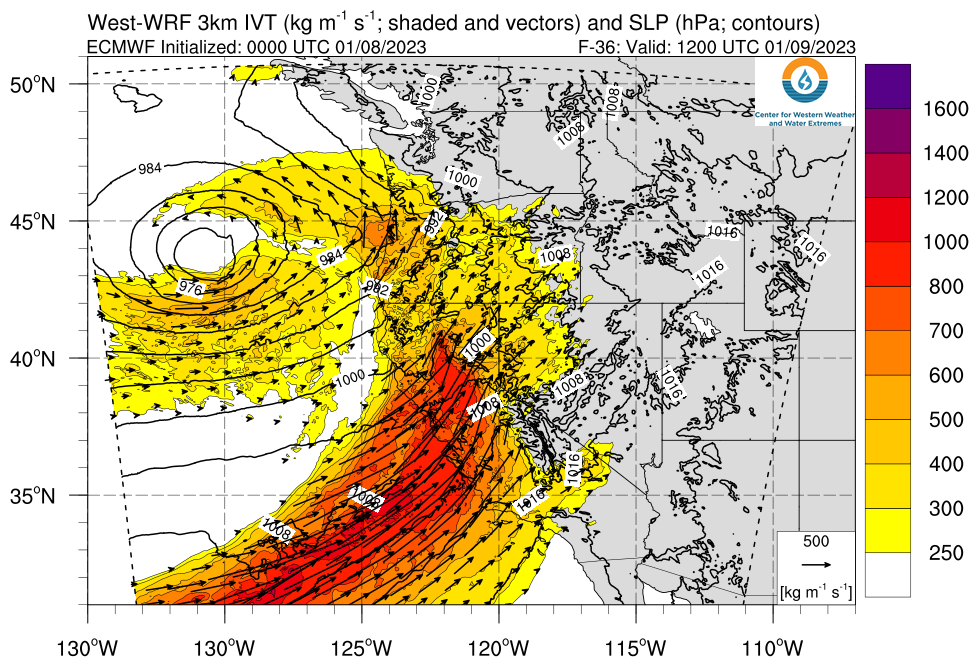
Another high-impact storm event will affect California beginning overnight tonight in NorCal and continuing through Tuesday AM in SoCal. This storm will take the shape of another strong atmospheric river. The exact position of this AR and its associated parent low pressure area has been bouncing around a lot in the models over the past few days, but today the consensus seems to have settled on a landfall somewhere around the SF Bay Area and a subsequent possible stall somewhere from the SF South Bay Area to Santa Barbara County. So it now appears that *peak* storm impacts will likely be felt a bit farther south than initially anticipated, likely from Monterey County south to Ventura County along the coast as well as the central & southern Sierra.
This will start as another relatively (but not extremely) warm storm, with high freezing lines during the storm’s initial hours (though these will fall following the initial cold front, and considerable snow is likely to much lower elevations after that happens). As noted, this will be a strong to perhaps very strong AR when it crosses the Santa Cruz, Monterey, SLO, and Santa Barbara County coastlines–and I would expect to see some very high rainfall accumulations over a 12-24 hour period in some of these areas.
Strong winds will once again be possible across much of California, from the North Coast south to at least LA County. Wind maxima may not be quite as strong in some areas as during recent storms, but the impacts may be just as high or higher given existing storm damage and completely saturated soils. So yet more downed trees and power outages can be expected. It’s a bit hard to say how strong wind gusts will get at this point as that will depend on the exact placement and evolution of the surface low, but widespread another round of 50-60+ mph gusts is certainly possible in parts of NorCal and extending southward along the Central Coast.
Worst-case flood impacts likely averted across NorCal, but high risk of significant flash flooding from SF south to Ventura County
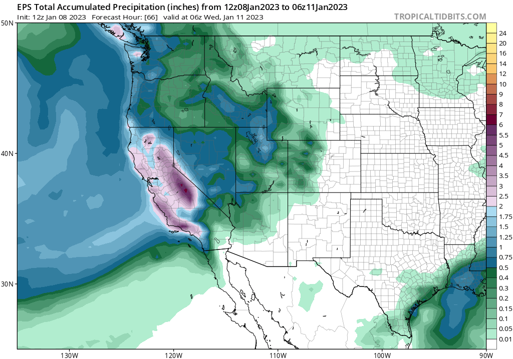
As noted above, this will be a high-impact storm for much of the middle 2/3 of California (i.e., much less so for far northern and far southern reaches of the state). The area of expected maximum precipitation has shifted southward vs predictions last week (not tremendously surprising–AR precip bullseyes almost always migrate latitudinally along the coast in medium-range forecasts). This is a mixed blessing: it *probably* means less extensive and severe flooding north of the I-80 corridor, where soil conditions are already “supersaturated” and rivers/creeks already running high. But it also increases the potential for dangerous flood impacts from about the Santa Cruz Mountains southward (and especially in Monterey, SLO, and SB/Ventura Counties).
To be clear: I still expect widespread flooding to occur on Mon-Tue across portions of central and northern CA. But mainstem river crests will likely not be as (extremely) high as they might have been north of San Francisco given last week’s forecasts (think minor to moderate vs. major flooding in most spots up north). Smaller creeks/streams are still at a high risk of potentially significant flash flooding during this event in this area, though. Quite a few shallow landslides/mudslides are also likely, as well.
At this time, I am more concerned about the potential for widespread and possibly severe flash flooding/debris flows/landslides along the Big Sur coast southward into the Transverse Ranges of SoCal. This is not only where the strong AR is now expected to spend the most time traversing, but may also be the target of some rather intense convective activity given the considerable surface-based instability associated with this storm. In fact, the AR itself may have embedded lightning and locally torrential downpours–especially south of the SF Bay Area–with very high 1-hourly precipitation rates. This is the kind of setup that greatly elevates concern regarding major flash flooding/debris flow risk along both Big Sur coast and Transverse Ranges given their tendency to intercept massive amounts of precipitation over very short periods of time during conditions favoring “training” bands of convectively-enhanced precipitation. In addition, rivers in this area may also flood rather significantly in addition to the flash flood risk within smaller water courses.
As noted above: this storm will be associated with an unusually high amount of surface-based atmospheric instability (i.e., CAPE), and there will be some pretty impressive wind shear present as well. Together, these two ingredients could produce some strong to locally severe thunderstorms–likely containing torrential downpours, locally damaging straight-line winds, and possibly even a waterspout/weak tornado or two in coastal areas (especially central and southern CA). Behind the front, a secondary wave of numerous heavy showers and scattered thunderstorms will sweep across the entire state (north and south)–and I would not be surprised to see additional localized flash flooding/wind damage from these convective bands that will continue into Tue in most areas.
It is also worth mentioning that soils are so saturated across northern and central CA that if the AR comes in even slightly stronger than anticipated, stalls longer than anticipated, or hits farther north than anticipated (all low probability but high consequence scenarios, given antecedent conditions), impacts could end up much higher than described in this blog post. But I’m focusing on the most likely outcome as I see it at the time of this writing.
Very active pattern continues for next 7-10 days, but hints of a break after that?
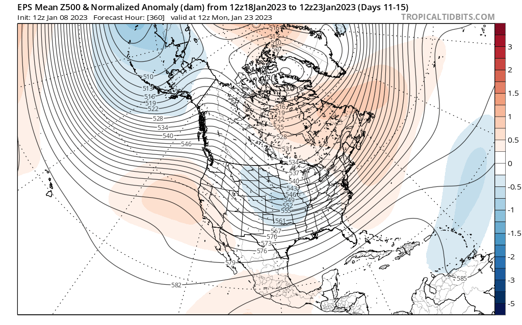
A very active pattern is expected to continue across all of California for the next 7-10 days. I won’t try to pin down the details at this point; suffice it to say that multiple additional moderate storms are likely and another strong storm two or two are possible at some point as the large-scale pattern remains favorable. These would likely be relatively cold storms, with good accumulations of mountain snowfall and fewer concerns regarding flooding from snowmelt. Flooding concerns will likely persist to some extent during this period, although *right now* it does not appear they will be as high as during the imminent Mon-Tue event.
And looking even farther out, toward around Jan 20 (~10-12 days from now), there are growing hints in the multi-model ensembles of a dry (or at least drier) pattern developing. Weak ridging will likely at least take the edge off flooding concerns during this period, so some of the “extremely into late January” model runs don’t currently appear likely (whew!). That’s subject to change, but I do think the storm train will lessen during the second half in the month. But in the meantime, we still have an extremely active weather week coming up statewide.