A modest “one and done” storm early next week, but trend toward re-intensifying drought continues
Much of California, as well as adjacent states, on track for driest Jan-Mar period on record
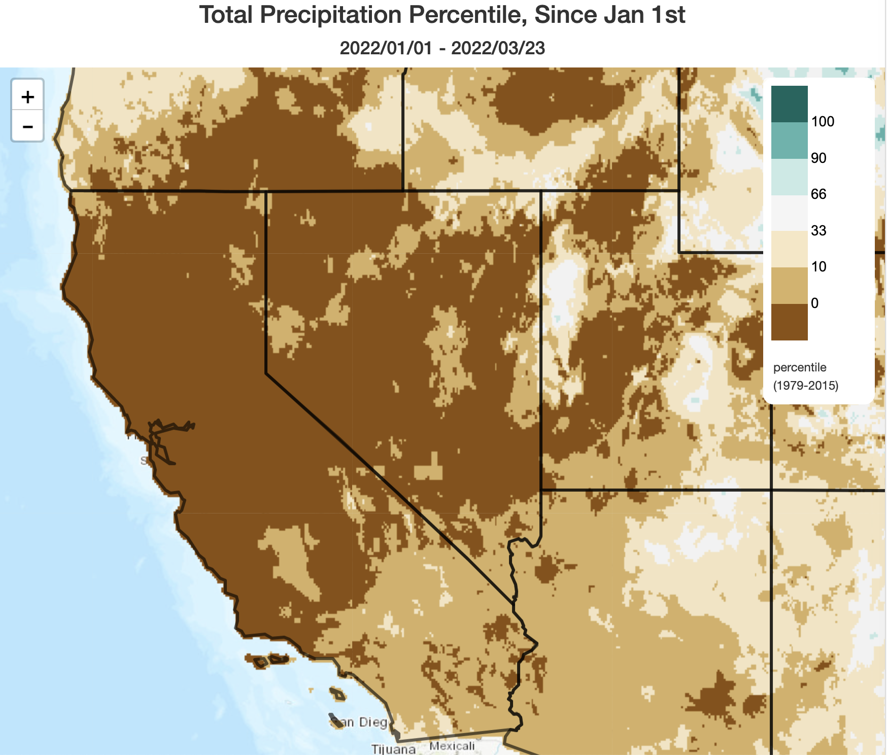
Well, it has been almost completely dry across California since my last blog post in early March. This ongoing Jan-Mar dry spell has been truly incredible across a broad swath of the West centered on California, and numerous records for dry conditions during the ostensible “wet season” have been shattered. Across most of California and parts of adjacent states, we have just experienced the driest Jan 1 – Mar 24 period on record. Even with some precipitation expected just before the end of the month (see more below), many spots are still likely to set new records for driest Jan-Mar period on record in well over a century. Virtually all of California is now below average in the precipitation department for the Water Year to date.
In the meantime, temperatures have generally been above average as well, with periods of record high temperatures over the past couple of weeks. Sierra Nevada snowmelt has begun to accelerate, and statewide snow water equivalent is now below 50% of average for the date and decreasing rapidly. All in all, this has been a remarkable trajectory for a Water Year that started with all-time record precipitation thanks to the “Bombtober” extreme atmospheric river event in NorCal.
Some good news in the short term, especially in SoCal: soaking rains possible across southern 2/3 of CA this weekend!
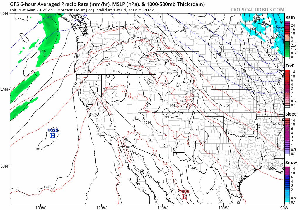
I do, at least, have some good news to report in the very short term: it does look likely it will probably rain later this weekend into early next week across the southern 2/3 of California, and it could be a decent soaking in some spots. While this will be a single “one and done” system, it will have a favorable overwater trajectory and will approach California directly from the West–affording fewer opportunities for significant weakening prior to landfall. On the plus side is this trajectory, plus some modest jet-forced lift. Detracting from this system will be its relatively fast motion plus very dry antecedent airmass, which will probably decrease precipitation totals to some degree relative to explicit model output at the moment. Still a broad portion of SoCal stands a good chance of seeing a solid 0.5 – 1 inch (locally more in orographically favored areas) and perhaps half that across portions of NorCal (some spots up north will likely see less, though). Right now, this definitely looks like a precipitation event that will mainly favor SoCal (vs. NorCal).
Given the lateness of the season and the strong sun angle/decent jet forcing, there could potentially be a bit of convective activity associated with this system on Monday (mainly south of the SF Bay Area). At the moment, I am not anticipating a widespread/significant thunderstorm outbreak, but there could definitely be some localized downpours or lightning strikes.
Snow levels will be pretty high in the mountains, as this will be a fairly warm storm. So I don’t think this system will meaningfully increase the now well below average statewide snowpack–although it will moisten soils, and give the landscape a break from unrelenting dryness these past few months. It’s something!
Not-so-good news in the medium to long term: all signs point toward widespread extreme drought by mid-summer
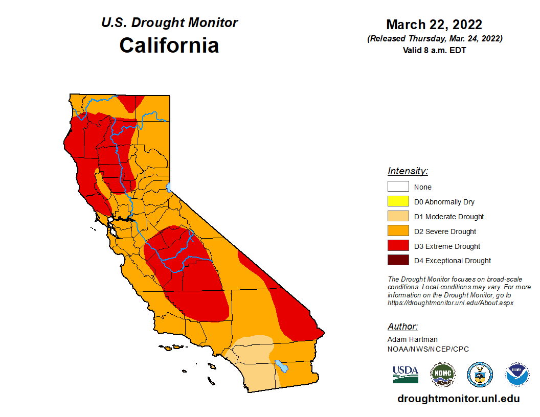
Unfortunately, I really don’t have much good news to report regarding the medium to long term outlook. As mentioned in the last blog post, multi-model ensembles continue to point to a drier than average spring across the entire West, including California, with warmer than average temperatures continuing into summer. All of this points to continued worsening of already severe to extreme drought conditions across California and in nearby states. And since we’ll now be heading into Year 3 of severe drought in many places, the consequences from a water supply and ecology perspective (which includes wildfire risk) will begin to escalate even further than they did last year. I certainly expect an early start to the California fire season at this point, and all signs point to the potential for a high level of large/severe fire activity later in the season (so both an early start, and a more severe peak, than the long term average. Once again). It’s still too early to talk about ENSO and the next Water Year, so I’m leaving that conversation for later in the summer when we make it to the better side of the “Spring Predictability Barrier.” I suspect there will be plenty of drought and wildfire-related discussion between now and then…so stay tuned.