As persistent West Coast ridge builds, California (mostly) warms up and dries out
Taking stock: a good start to Water Year 2021-2022
I’ll keep this part pretty short and sweet: for the Water Year to date, most of California is in pretty good shape when it comes to precipitation. And that’s good news, given the historic severity of the regional drought as recently as late September. (I discuss this broader context in more detail in the second to last section of this post).
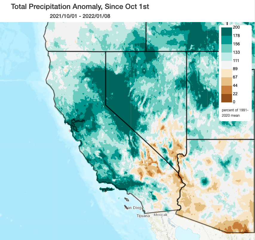
In the meantime, the insane period of sustained record warmth across the California interior (especially at higher elevations) that was much discussed this summer and early autumn has finally abated. Across most of the state, temperatures since Oct 1 have been right around average (locally a bit above or below, depending on where you are). December was still a near average month, temperature-wise, on a statewide basis–although the second (and snowy, in the mountains) half of the month was colder than average in many spots. Notably, the relatively cold December temperatures along the West Coast were in truly extreme contrast to the widespread all-time record warm conditions observed during December across much of the rest of the contiguous United States. In fact, according to NOAA, December 2021 was the warmest December on record for the contiguous U.S.
I would be remiss not to mention the very heavy and exceptionally disruptive Sierra Nevada snowfall that occurred in December–mostly notably in the lower foothills between 2,000 and 4,000 feet elevation. In that elevation band in particular, where very heavy snowfalls are much rarer than at pass level, the December snowfall has produced extreme (and in some cases, ongoing) disruptions to transportation and electrical infrastructure. There are still at several thousand power customers who remain without electricity or road acces due to an extremely high number of downed trees and powerlines–over two weeks after the initial event (I know there are at least a couple of Weather Westers who fall into this category). Hopefully, the upcoming warm and dry spell will help crews finally clear the remaining roads and restore power to the remaining outage areas rapidly over the next day or two. It is also worth noting, as several ecologists and fire folks have already pointed out to me, that the very high volume of downed trees and branches that occurred during this event will probably increase fire risk in that foothill elevational band this coming summer/autumn due to the added dead/down fuel density and access problems on remote/forest roads that will not ordinarily be accessed by crews until needed.
Strong, persistent West Coast ridge developing; warmer and much drier for most of CA
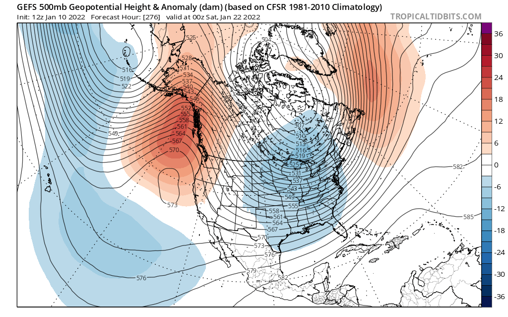
In the coming days (and probably for the next 2-3 weeks), a persistent ridge of high pressure will set up shop just west of the West Coast–effectively blocking the jet stream and bringing an end to the December parade of cold storms across California. There is strong multi-model ensemble agreement regarding the overall persistence and (more importantly) positioning of this ridge, which will very likely keep most or all of California somewhat warmer and much drier than average for mid-January over the next 2 weeks. 2-week dry spells are not unusual in California, and indeed seem to have a slight climatological preference for the month of January. So this multi-week ridge, in and of itself, is not especially unusual for this part of the world. How long it persists into late Jan, Feb, and beyond is more important from a seasonal and drought-busting (or not) perspective (more thoughts on that below). All in all, though, it appears this will be a prolonged period of fairly benign weather across California and much of the rest of the West. After the December deluge, and enormous Sierra Nevada snow accumulations, this pattern will cause statewide snow water equivalent “percents of average” for the date to fall precipitously–from about 133% of average for the date (as of today) to around or perhaps even below 100% of average for the date by late Jan.
Some “ridge undercutting?” possible? Yes, but odds of significant event appear low
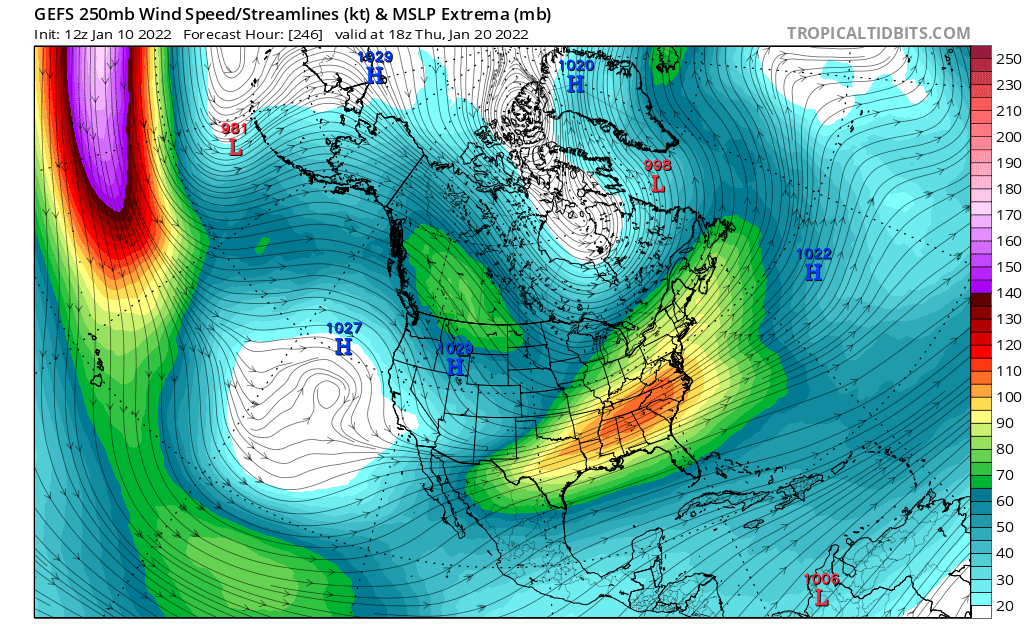
There is one caveat to the above “dry ridging” pattern discussed above: the potential for some modest ridge undercutting by a sneaky subtropical jet. This does not appear to be a particularly robust undercutting setup, and I don’t think it’s likely the West Pacific jet will break through anytime soon. But a weak subtropical jet spur may develop to the southwest of California during this period, possibly favoring the development of cut-off lows south of CA. These would be most likely to bring rain to Baja California, not the state of CA, but there is a modest chance (maybe 30%) that one or two of these cut-offs could drift far enough northward to generated isolated to scattered showers/isolated thunderstorms over some portion of (mainly southern) California. The model operational runs keep hinting at this possibility, although the ensembles suggest it’s not likely to happen in any widespread sense. Hydrologically significant precipitation appears quite unlikely, despite this caveat, over the next 2+ weeks–but this could certainly make for some nice sunsets/cloud watching down south (and maybe a shower or two at some point). Every once in a while, a low-key undercutting pattern like this can become unexpectedly active–but right now, there are no indications of that.
Seasonal outlook for the rest of the Water Year: odds still favor dry (but context matters)
The January update of the seasonal models has just come out, and they’re continuing to suggest a relatively high likelihood that the peak of the rainy season (Jan-Mar) as well as the spring (Apr-Jun) will be drier than average across most of California except for perhaps the very northernmost portion.
Despite some claims to the contrary, this is actually consistent with long-range seasonal predictions originally made several months ago. Signals regarding Sep-Dec were decidedly mixed–with the multi-model seasonal ensemble suggesting that Sep-Nov would be drier than usual but that December would see increased odds of being a wetter than usual month. Sep and Nov were indeed quite dry across most of California, and December was quite wet indeed. In terms of the broader atmospheric pattern: a persistent and strong blocking ridge did indeed develop, as advertised, over the far North Pacific and has thus far lasted most of the season.
To illustrate this, I pulled the following quote from the September 16th blog update:
What do the seasonal models say? Well, they appear to be making a prediction that’s very consistent with what I would estimate from our own prior work–they are suggesting fairly high odds of yet another dry winter across most or all of California (with confidence highest across the southern 2/3 of the state). Interestingly, these same models are suggesting that following a dry autumn (except perhaps along the North Coast), December could potentially be a pretty wet month in parts of CA! But thereafter, there seems to be a fairly strong indication that multi-month ridging will take hold and could keep California much drier than average during the peak rainy season months of January through March (and into the spring, as well, although that’s more speculative at this early juncture).
-Daniel Swain, Sep. 16, 2021 (https://weatherwest.com/archives/10965)
The real miss in that outlook was October (i.e., “Bombtomber,” as it’s come to be known in the comments section). That event was essentially a single atmospheric river/low pressure bomogenesis event–albeit quite an extreme one–and brought record-breaking single day precipitation to a fairly broad swath of Northern California. And it’s critically important to note that seasonal predictions simply cannot, and are not designed, to capture the behavior of individual storm systems that far in advance. This single storm event was so wet that it actually brought parts of NorCal, especially around the I-80 corridor, a substantial fraction of its annual average precipitation in one fell swoop. This was clearly good news–since it has really helped mitigate short-term drought severity along that corridor–but it was largely a matter of good luck, rather than a blown seasonal forecast.
So if the seasonal models continue to be about as correct as they have been so far this season, I’d continue to put my money on a drier than average outcome for the rest of the season. Not completely dry, of course; seasonal predictions could not tell us that anyway. But even here, the broader context matters greatly. In the long term, California had been experiencing a record-breaking, historically severe drought heading into Water Year 2021-2022. Then, following “Bombtober” and the December deluge, many folks breathed a (much needed, and justified) sigh of relief–since those two single wet months singlehandedly ended fire season, added some critically needed flow into extremely low rivers and reservoirs, and delivered an impressive early season snowpack. All of that is great news.
But much of California remains in severe to even extreme drought conditions as of early January, since a mere month or two of wet (even very wet) conditions simply cannot erase the ecological, hydrologic, and groundwater effects 2-3 extremely dry and record warm preceding years. With a dry “back half” to winter looking like the most likely outcome, it seems highly likely that California and most of the rest of the broader Southwest will still be experiencing a significant drought throughout the coming calendar year. With warming temperatures and increasing evaporative demand due to global warming, it’s just getting that much harder to escape the effects of landscape-scale aridification. That said, the drought we’ll likely be experiencing come summer won’t be nearly as bad as it would have been had we not had the October and December we just did–arguably, parts of California just narrowly averted a pretty dire escalation of drought consequences in 2022 thanks to just a couple of storm events. Flying by the seat of our collective pants, as it were (which, although it really should be obvious by this point, is decidedly not an effective long-term water management plan).
New research: co-occurring ozone and smoke pollution events have dramatically increased in U.S. West
I wanted to highlight some new research that was published last week in Science Advances, and was led by my colleagues at WSU Vancouver (Dmitri Kalashnikov is the lead author). In this work, we looked at a type of event that most folks reading this blog post have (unfortunately) become quite familiar with in recent years: extreme air pollution episodes in the Western U.S. Specifically, we considered the frequency, geographic extent, and population exposure to co-occurrence of extreme ground-level ozone and particulate matter (PM2.5) pollution for the past two decades (the full period over which records exist). We found widespread, substantial increases in such summer co-occurrence events that have affected virtually every major population center from the Pacific Coast to the Rocky Mountain Front Range. We further found that these increases are strongly associated with a) rising summertime extreme temperatures, b) increasing wildfire extent burned, and c) increased frequency of strong warm season high pressure patterns that cover most/all of the West. Although we don’t conduct formal climate change attribution in this particular analysis (we exclusively use real-world observations, not climate model simulations), it’s pretty clear that there’s a strong human fingerprint on at least two of those primary factors (i.e., increasing summer heat waves and wildfire area burned).
The full paper is freely available/open access, but if you’re interested in learning more I’d suggest starting with the detailed Twitter thread (first two Tweets from which are linked below).
As persistent West Coast ridge builds, California (mostly) warms up and dries out Read More »