Heat, humidity, and some thunderstorms to come as cut-off low sets up shop south of blocking ridge. Plus, some brief thoughts on the Maui wildfire disaster.
Prolonged period of below average temperatures in CA now in rear view mirror
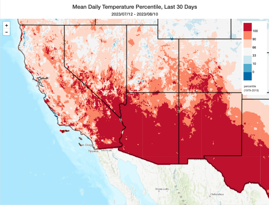
For most of California, the unusually cool conditions earlier this summer have given way to quite the opposite: the last 30 days have been among the warmest such periods on record for a good portion of the southeastern interior desert portions of the state. Further inland, in a broad swath from the Mojave Desert to central Texas, the interior Southwest experienced its singularly hottest summer month on record–in some places exceeding historical records by a wide margin.
It wasn’t hot everywhere in CA during July: unusually cool near-shore ocean temperatures off of NorCal kept things relatively chilly along the coast still. But even this appears likely to change in the coming days and weeks as a surge of warmer water and decreased upwelling arrives.
Strong ridging over PacNW plus cut-off low west of CA = interesting weather
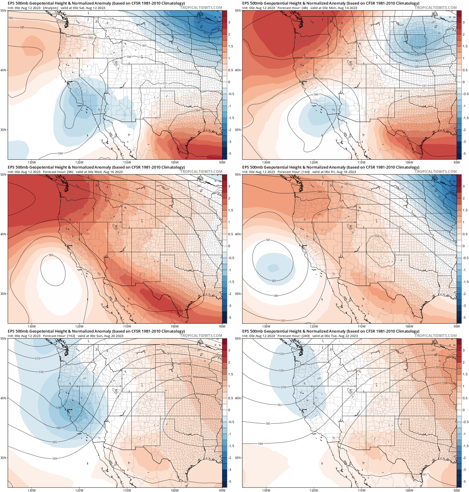
The next 10 days will feature a relatively active summer weather pattern over California and the West Coast. The two major players? An existing cut-off low pressure system–which brought some localized showers and thunderstorms to the Central Coast when it synched up with moisture from former East Pacific Hurricane Eugene late last week–will deepen slightly as it retrogrades (moves westward) and then stalls west of the California coast later this weekend. It will remain there for most of the following week, including relatively deep south/southeasterly flow across the state. Meanwhile, a very strong ridge of high pressure will develop over the Pacific Northwest. (It’s the weak flow on the southern flank of this ridge that will allow the cut-off low to linger for days.)
Hot weather across north and interior CA (and OR), plus (mainly mountain/foothill) thunderstorms, will increase fire risk
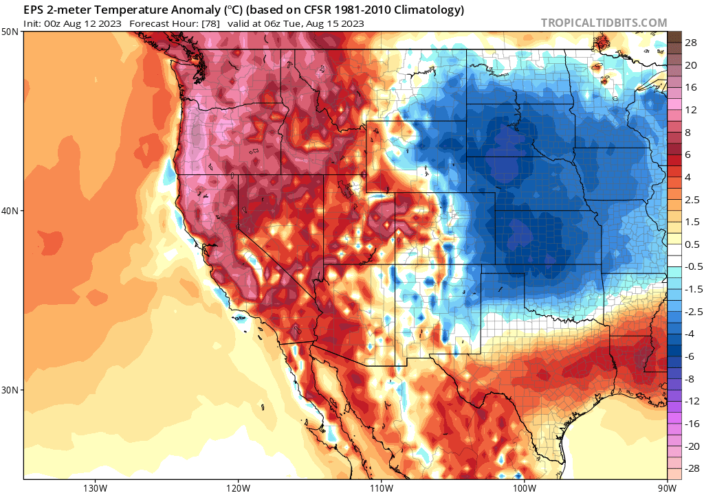
Temperatures will rise significantly along the entire West Coast as the ridge strengthens, and an intense/long-duration/record-breaking heatwave will likely result over Oregon. Meanwhile, further south across California, conditions will be quite hot across the interior (but generally not extremely so). One exception may be across interior and higher elevation parts of far northern California, where the upcoming heatwave could become intense enough to break some temperature records (that would include the mountain valleys in NW CA and the northern mountains, including the Shasta region). Elsewhere, away from the immediate coast, folks can expect a relatively prolonged period of unusually hot August weather.
Speaking of the immediate coast: things will likely start to “heat up” there as well in relative terms. While this heatwave will not feature the kind of strong offshore winds needed for genuinely hot temperatures on the beaches, it will greatly suppress coastal upwelling–warming near-shore sea surface temperatures and allowing both overnight and daytime temperatures to become much milder than in recent weeks. Additionally, a very large warm water mass associated with a remarkable marine heatwave that has been percolating in the offshore waters of the North Pacific for most of the summer is now starting to reach the NorCal coast. This, in combination with a period of decreased upwelling, could increase coastal temperatures significantly in the coming days.
In addition to the hot weather inland and notably milder weather along the coast, this pattern will draw some subtropical moisture up from the south and southeast and will increase mid-level atmospheric instability. In addition to increasing the level of ambient mugginess amid the heat, scattered thunderstorm activity will be likely across both the Sierra Nevada and northern mountains on and off for the next week, and occasionally in the SoCal mountains as well. More notably, pattern recognition (and, to a lesser extent, model ensemble output) suggests that there may be at least 1 or 2 opportunities for thunderstorm activity to expand beyond the mountains in NorCal, mainly over the foothills but perhaps also over the Central Valley and even coastal regions at some point. This is the kind of pattern that would potentially support a mix of dry and wet thunderstorms.
At the moment, there is no indication of a widespread dry lightning event that would pose extreme fire weather concerns. But there is the potential for at least isolated dry lightning strikes (or wet strikes in very dry vegetation) amid a significant heatwave–so fire weather concerns will, at a minimum, be elevated. This is also the kind of pattern where the possibility of more widespread lightning (i.e., at least isolated activity all the way to the coast) is difficult to discern more than a day or two in advance because it will depend on the eventual evolution of subtle atmospheric features. And because this overall pattern is expected to persist for a week or longer, that raises the odds that the ingredients will eventually come together at some point to support some isolated activity at lower elevations. If there is a major increase in the likelihood of a more widespread thunderstorm event in CA this week, I’ll offer brief updates via Twitter and my live YouTube office hours.
Medium term looks potentially interesting, with persistently warmer than average temps and possibility of hurricane-derived tropical moisture through end of Aug
And the potentially “interesting” weather period for California doesn’t end this week. There is strong confidence that hurricane season in the East Pacific will ramp up considerably over this period, with the potential for two or three new named storms to form in the next two weeks. Uncertainty remains high this far in advance, but there are hints in the ensembles of a 20-30% chance that one of these systems (or its remnant moisture) could recurve to the north/northeast at some point during this period. If that happens, there could potentially be a more widespread outbreak of thunderstorms somewhere in California during that period. It’s too early to discuss the details, but mid August into early October would be the most climatologically favored for this to occur–especially during a strong east-based El Niño year (as this one is shaping up to be).
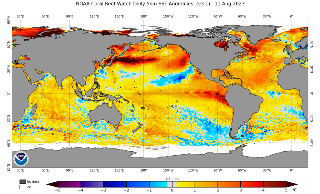
El Niño continues to strengthen and strong event likely by winter; separately, major marine heatwave inches closer to CA coast
El Niño continues to intensify in the tropical East Pacific, and by all accounts it’s looking like a doozy of an event. NOAA projections now formally call for a >95% chance that El Niño conditions persist through winter, and (more importantly for a CA winter precipitation perspective) >66% odds that the event will become a strong one. Seasonal predictive model ensemble are already depicting greatly-above-baseline odds of a wet winter across most of CA during 2023-2024–a signal that’s likely coming almost exclusively from the high likelihood of a strong, east-based event this year. I’ll talk more about the caveats and potential consequences of that outlook in future weeks/months, but for now I just wanted to give this brief ENSO update.
Brief thoughts on the recent wildland-urban interface fire catastrophe on Maui
Earlier this week, a fast moving wind-driven wildfire on the leeward (dry) side of Maui burned essentially the entire community of Lahaina–exacting a very high and still climbing human toll as well as destroying over 2,000 structures. As of this writing, the official death toll stands at 80 but well over 1,000 people are still on the list of those missing. Many of those on that list will likely turn out to be okay and are simply displaced amid widespread telecommunications outages. But even as it stands now, the devastating events in Lahaina already comprise the second deadliest wildfire in modern North American history (just behind the 2018 Camp Fire in Paradise, CA). Unfortunately, it appears that the death toll will rise further as search teams move in–perhaps considerably–meaning that the deadliest contemporary American wildfire will likely now have occurred in the tropical Hawaiian Islands.
This event was, in many ways, eerily reminiscent of other recent deadly wildfire catastrophes in California, Colorado, Australia, and Greece. Severe antecedent drought conditions on the leeward side of Maui and the legacy of poor land management practices–in this case, massive overgrowth of invasive tropical grasses (locally 6-8+ feet tall) in abandoned sugarcane plantations upwind of town–helped set the stage for the disaster. Then, a severe downslope windstorm (with gusts up to 80 mph) caused by a combination of strong high pressure to the north of Maui and (to a lesser extent) strong low pressure to the south of Maui associated with Hurricane Dora downed numerous powerlines in and immediately upwind of town. It remains unconfirmed at this point what the actual cause of ignition was, but evidence suggests there were probably multiple ignitions from electrical infrastructure.
The flames moved with astonishing speed into town–so fast that most folks had very little or no warning before the fire arrived on their doorstep. A frenzied and chaotic self-evacuation ensued, with many folks abandoning their vehicles on jammed and flaming debris-strewn streets and running on foot to the Pacific Ocean. The fire quickly burned through essentially the entire town and all the way to its waterfront–at which point, incredibly, burning embers blown by the violent gusts ignited the docks and piers extending into the water and even some vessels anchored offshore. Hundreds of people apparently spent hours in the waters of the Pacific to escape the flames, many of whom were ultimately rescued by the Coast Guard.
As much as it might surprise some folks, the Hawaiian islands are no stranger to fire. Nearly all ignitions today are caused by human activities (though most are accidental). Wildfire risk is rising, especially on the dry sides of the islands (which, in some cases, receive an annual average precipitation similar to that of Los Angeles), due to a combination of unmanaged invasive grasses building up huge fuel loads on abandoned plantations and climate change–which is likely increasing the duration and severity of droughts on the lee sides of the islands and the intensity of wet-dry cycling of precipitation (which favors extra vegetation growth, and then rapid drying of that extra growth during high risk periods). Here, too, as in so many other places, subdivisions have been built and expanded that increasingly extend into high fire risk zones. In fact, in County of Maui planning documents, nearly all of Lahaina was characterized as being at high to extreme wildfire risk.
Ultimately, this tragedy–though genuinely shocking in its magnitude–is unfortunately part of a repeating pattern than has become uncomfortably familiar to those who study wildfires and wildfire disasters. Most of the systemic failures that have led to increasingly severe life and structure losses during wildfire events in the western U.S. as well as other fire-prone regions globally played out again on Maui. I explored many of these issues in more depth in two separate YouTube live office hours sessions this past week (recordings can be found here and here), as well is in this Twitter thread. But I will say this here: personally and professionally, it has been quite disconcerting to watch (sometimes from afar, but other times up close) the continuing escalation of wildland-urban interface fire catastrophes over the past decade, both in California and beyond. California thus far in 2023 has experienced a mercifully mild fire season to date (as predicted)–but that reprieve won’t last forever, and we desperately need to be applying the hard-learned lessons from these recent disasters in our own communities and backyards.
My 2024 weather and climate calendar is now available!
As of August 8, my extreme weather and climate calendar is now available for immediate shipping! Thanks to those who pre-ordered–and for those who are interested, the publisher is currently offering a 10% discount if you use the coupon code “CALENDAR24.”
