Robust spring storm to bring rain, mountain snow, thunderstorms to California
The strange Water Year 2020: very dry north, not so dry south
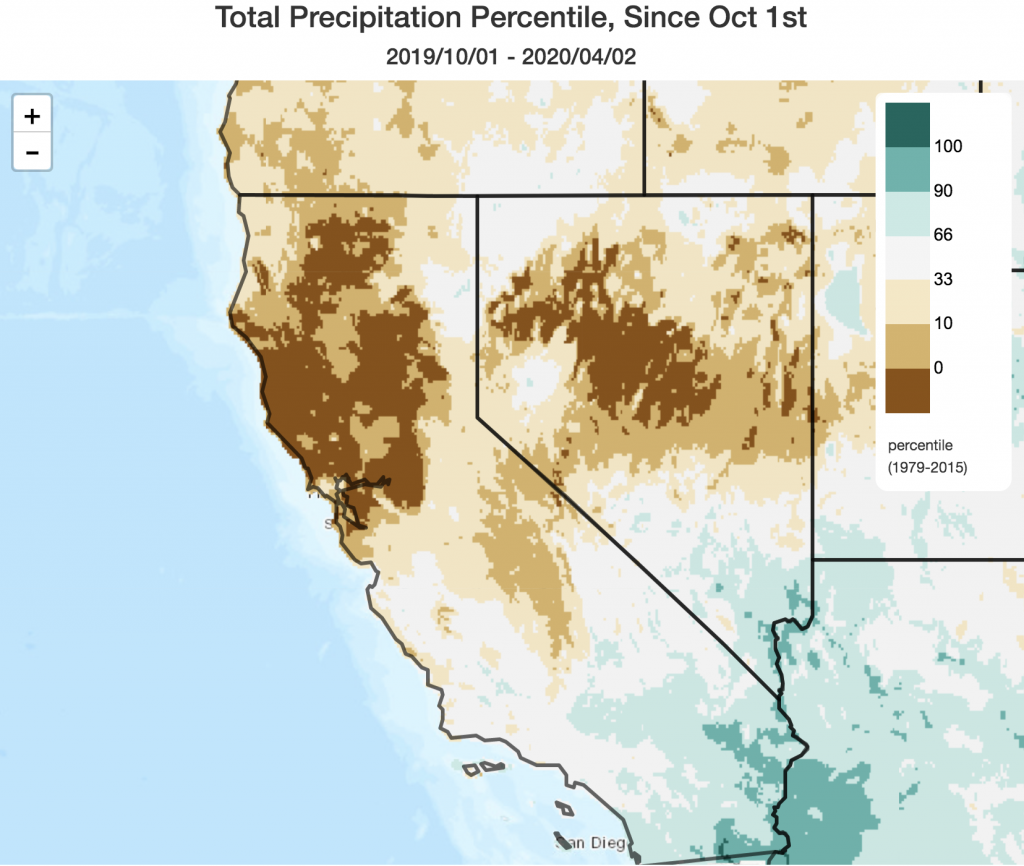
In many ways, the present Water Year is a tale of “haves” and “have-nots.” Nearly all of Northern California remains far below average seasonal precipitation. In fact, a fairly broad portion of the northern third of the state is still experiencing its driest water year to date in at least 40-50 years. Statewide snowpack water equivalent, even following recent snowstorms, is only 54% of average for the date. The situation is very different in the southern third of California, however, where a fairly consistent parade of landfalling “outside slider” systems over the past 2 months have boosted seasonal totals substantially. Many spots from Santa Barbara southward are relatively close to seasonal averages, and even farther south along the coast (and east, into the deserts) seasonal totals are now running *above* typical seasonal values. This has resulted in a strongly precipitation anomaly dipole from north to south–with potentially significant implications for the upcoming wildfire season (as discussed further below).
Active weather this weekend into early next week courtesy of strong spring storm
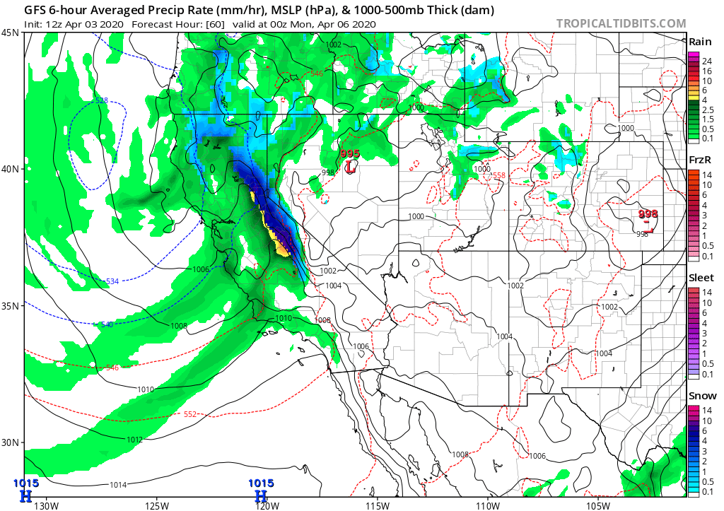
It’s going to be a good weekend to stay at home and help “flatten the curve” just about everywhere in California. A pretty robust spring storm will affect the entire state beginning later Saturday into Sunday, bringing widespread rainfall, heavy Sierra Nevada snowfall, and a pretty good chance of thunderstorms in some areas.
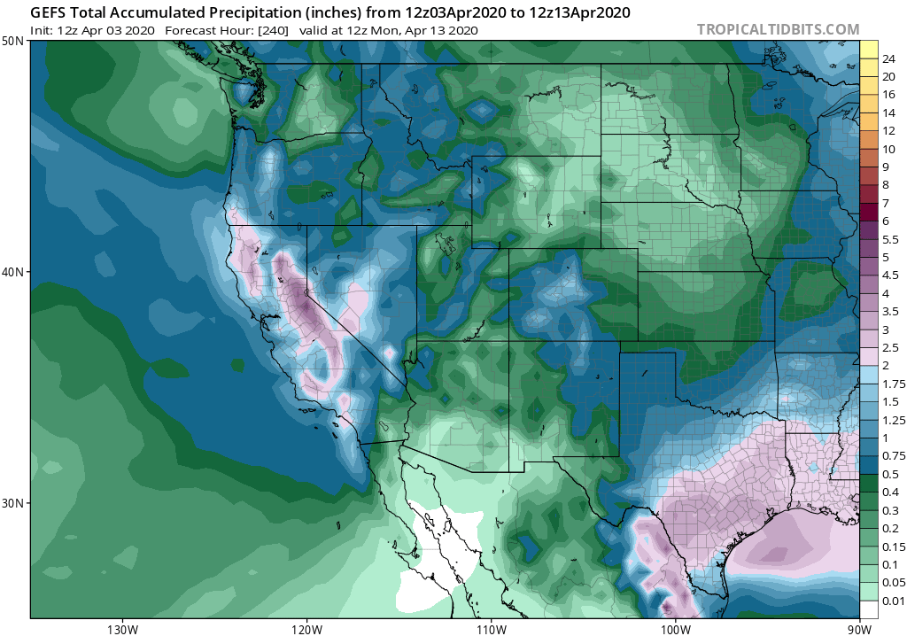
This will be a pretty cold storm for April, so snow levels could be as low as 3,000 to 3,500 feet in Northern California and relatively high snow ratios are likely in the mountains. In fact, a couple of feet (or more) of new fresh powder could accumulate at the highest elevations between now and Wednesday next week! Precipitation will be lighter at lower elevations and closer to the coast, although totals will (once again) be higher in southern California than northern California and could be locally heavy from about Los Angeles southward. Unfortunately, the regions with the largest cumulative seasonal precipitation deficits will see the least precipitation from this system–only modest precipitation is expected in the Bay Area and the Central Valley/foothills. Still, these April showers will be widespread and will help keep things damp for some time to come.
The upcoming system also looks pretty convectively active, with thunderstorms already occurring out over the open water upstream of California. With quite cold air aloft and even a modest amount of vertical shear over NorCal on Sunday/Monday, scattered thunderstorms are likely to develop over the Central Valley (some of which could be strong/severe, with some hail or even an isolated tornado. ‘Tis the season.). Elsewhere, the risk of severe weather is minimal, but isolated thunderstorms/bursts of small hail will be possible just about anywhere in the state Sunday/Monday.
Calmer conditions and seasonable temperatures by mid-April
At the moment, multi-model ensembles are indicating a return to a drier, more stable pattern by mid-April–which would be consistent with typical seasonal drying heading into the dry season. So it does seem increasingly likely that the widespread precipitation this weekend may be our best bet for recouping some of the seasonal precipitation deficit in NorCal before the start of the long dry season to come. A bit of further good news, though, is that there are no significant heatwaves on the horizon through at least mid-April–in fact, if anything, there is a slightly tilt toward cooler-than average temperatures out through the middle of the month at the moment.
Weather West and COVID19: guidelines for a welcoming & informative comments section
I think it goes without saying at this point that these are trying and unprecedented times. Those who frequent the Weather West comments section are probably aware that there has been some fairly extensive discussion of all things related to the COVID19 pandemic. Under the circumstances, I feel this is appropriate. However, I would ask that blog regulars and first-time posters follow the following guidelines to ensure the comments section remains a welcoming and informative place.
1. Zero tolerance for misinformation. Posts that contain or encourage false or misleading information will be summarily deleted.
2. Please keep speculation and political discussion to an absolute minimum. I realize this is difficult, especially at present, but please try your best.
3. It would be especially valuable to hear personal perspectives from frontline health workers (doctors, nurses, aides) who are facing this crisis “on the ground.”
4. I know many of you are hurting, financially and otherwise, during this unprecedented time. If your small business is open in some limited capacity and needs community support, it’s okay to mention that here. Other offers of/requests for community assistance are likewise considered “on topic” until further notice.
5. Again, please be kind. Thank you!
Finally, I would like to remind everyone that I am *not* a virologist, epidemiologist, or public health expert (very, very far from any of those things). But I have spent a fair bit of time seeking out those who are highly qualified to offer commentary and information on these topics, and have compiled the following, ever-expanding public Twitter list that may be of interest to many of you.
A note regarding our new research on wildfire risk and climate change in California
The NIFC has just released its preliminary wildfire outlook for the first half of the 2020 fire season, and it’s a bit of a mixed bag for California. Early-season risk in May and perhaps June will likely be near or below average in southern California due to relatively amply late-season rains recently (and more to come this weekend). By mid-summer, however, above-average large fire risk is expected to develop across most of northern California due to the exceptionally dry antecedent conditions during autumn/winter 2019-2020. Personally, I would not be surprised if this elevated risk of wildfire persists into the coming autumn in NorCal, and may perhaps expand across parts of SoCal as well if this summer is particularly hot (as current long-range outlooks are suggesting is plausible). Therefore, I would (unfortunately) not expect a continuation this year of the relative wildfire reprieve California experienced in 2019.
Many readers may also be interested in new peer-reviewed scientific research, led by Michael Goss at Stanford University, that my colleagues and I recently published. This work, which was directly motivated by the catastrophic Camp Fire and Woolsey Fire firestorms in 2018, considers the role of changing climate conditions in driving changes in the frequency extreme fire weather risk days. The short version: climate change has already doubled the occurrence of extreme wildfire risk days since the 1980s, and further increases are likely as the climate continues to warm. At some point in the next month or so, I will have a full blog post write-up of these (and other related) recent scientific findings on climate and wildfire risk in California. But in the meantime, please feel free to read the underlying paper directly (freely available to all in access Environmental Research Letters) or explore this Twitter thread discussing key findings and implications:
Robust spring storm to bring rain, mountain snow, thunderstorms to California Read More »