A taste of April amelioration? Recurving West Pacific typhoon may help direct some substantial late-season precip to parts of NorCal, though SoCal remains dry
Driest and among warmest Jan to mid-April periods on record in CA
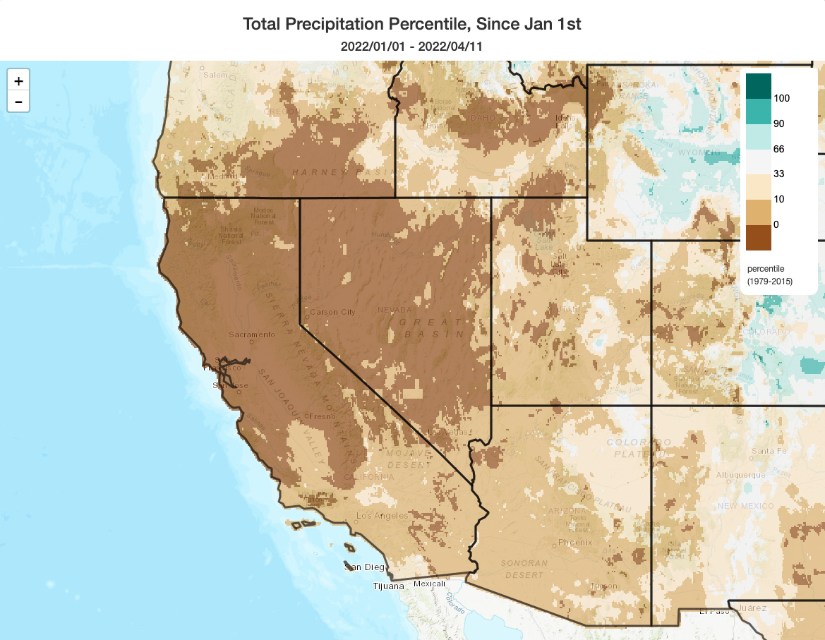
It has been an extraordinary start to the calendar year in California from a weather and climate perspective, and not in a good way. Precipitation has been so low that it has shattered all previous records for low Jan – mid-April precipitation virtually everywhere in northern and central California, and therefore also on a statewide basis. Additionally, periods of record heat have pushed up average temperatures during the period to very high levels relative to the historical record–many parts of CA have also experienced a top-5 warmest start to the calendar year on record in addition to the low precipitation records. As a result, Sierra Nevada snowpack has plummeted at a record rate–briefly falling as low as 22% of average for the date on a statewide basis. Wildfires have been ocurring essentially statewide for a couple of months now, and the NWS in Sacramento issued their earliest spring Red Flag Warning on record for the NorCal interior earlier this week.
Phew.
But at least in the short term, I do have some substantially better news to report (for the northern portion of the state, at least)!
Some (unexpected) good news in the short term in NorCal: substantial late-season precip may be inbound for some areas
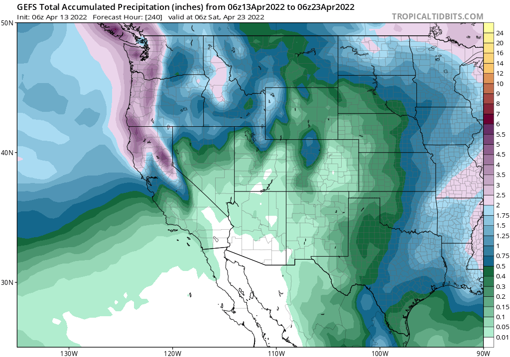
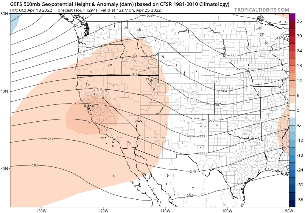
Multi-model ensembles have now converged on a North Pacific weather set-up that will favor wet conditions over the northern third of California for the next 7-10 days. In fact, the ensembles have trended slightly wetter as the potential event has come into focus–a welcomed change from the trend during much of this winter. As it currently stands, it appears that an anomalously deep NE Pacific trough will set up shop off the West Coast later this week, allowing 2 or 3 weather systems to cycle through over the next 7 days or so. While these systems will probably be confined to NorCal, with nearly all precipitation staying north of Monterey Bay, some spots along the North Coast and in the Northern Sierra could end up seeing pretty substantial accumulations of 2-3 inches of liquid equivalent (locally 5+ inches in the very wettest spots over the course of 7-10 days). While these precipitation totals are still quite small relative to accumulated annual precipitation deficit (which is running as high as 25-35 inches in some of these wetter NorCal spots), they will be pretty notable for an event occurring this late in the season. And while these will not be particularly cold storms, nor will they be particularly warm storms: it appears that there could be some pretty decent snow accumulation above 5,500 feet or so. In fact, I do expect statewide SWE to recover (though only modestly), perhaps getting back up as high as 30-35% of average for the date by Apr 20th or so (which is still, needless to say, really low–but better than it was).
Lower elevation areas away from the North Coast will be a bit more of a wildcard. Much of the Bay Area and Sacramento Valley stands a good shot at soaking rainfall from this pattern as well–probably 0.5 to 1 inches in many spots (although with the caveat that there could be substantial rain shadowing in some inland valleys). SoCal will mostly remain dry–perhaps completely so–though the period, so it is mainly the northern third (and to a lesser extent, the northern half) of CA that will reap the benefits of this upcoming pattern shift.
The culprit: a re-curving West Pacific typhoon (yes, one of those again)
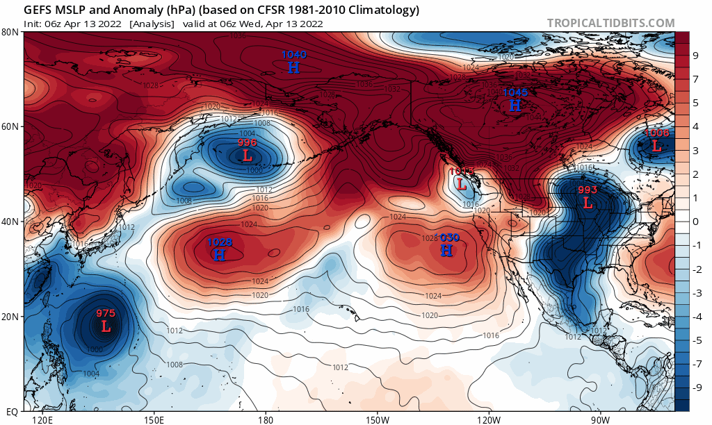
What’s the culprit behind this decidedly unexpected mid-April reprieve (perhaps leading to, given the apparent imperative to give an alliterative name to it, April Ameloriation)? As far as I can tell, it appears that the unusually deep West Coast trough/low that will be proximally responsible for the wet conditions in NorCal can be traced to the indirect effects of a recurving West Pacific Typhoon (Malakas).
This may be a familiar refrain for longtime blog readers: a significant fraction of “surprising” early and/or late season (autumn and/or spring) precipitation events (even in extreme drought years) in California appear to be driven by the perturbation of the North Pacific jet stream by the injection of moisture and vorticity well upstream. Often, these ingredients are contributed by strong tropical cyclones (drawing their energy from the warm oceans) that rapidly weaken and transition into extratropical cyclones (drawing their energy from the latitudinal temperature gradients in the atmosphere) as they move over much colder waters and become injected into the usually powerful jet stream over the NW Pacific. In doing so, these moisture/spin injections can pump up ridging over the Central Pacific in such a way that can cause either a strong ridge (with warm and dry conditions over CA) or a strong trough (with cool and wet conditions over CA), depending on the exact longitude at which it occurs. Fortunately, in this case, it appears that a wetter/troughier outcome will come to pass. It is worth noting that such occurrences–where a significant fraction of the seasonal (in this case, spring) precipitation falls essentially during a single event–are virtually impossible to foresee at seasonal prediction scale. (So there can be, and probably always will be, the potential for these kinds of events to “surprise” us in the final hour even during the driest years.)
Long term still suggests intensifying drought & a bad fire season, but pattern may still bring tangible short-term relief in NorCal
From an ecosystem and wildfire perspective in NorCal, all this late season precipitation will be good news. It will probably contribute some modest transient streamflows and will measurably bolster mountain snowpack, perhaps taking the edge of now-extreme drought conditions in many of these areas. It will also put a damper on fire season for a 2-3 week period in many parts of NorCal–no small thing these days, and perhaps extending the window for prescribed burning and ongoing fuels reduction projects further into May. One downside may be from an agricultural perspective: substantial late season rainfall can damage a number of crops that are commonly grown in the Central Valley (though it does look like the San Joaquin will mostly likely be too far south to see much precipitation out of this). But overall, it is nice to be able to report that a substantial swath of the state will see some quite respectable precipitation over the next 7-10 days. Thereafter, things do appear likely to dry out again by late April, with a return to ridging and somewhat warmer conditions.
New research: climate change is increasing the risk of extreme precipitation following extreme wildfire conditions in the Western U.S.
My colleagues and I have recently published some new research looking at the changing occurrence of extreme precipitation events following extreme wildfire burning conditions in a warming climate. We find that climate change is increasing the likelihood of extreme precip-following-extreme fire weather conditions across essentially the entire American West, though more rapidly in some places than others. Interestingly, the increase in extreme precipitation events is just as important (if not more important, locally!) as the increase in extreme fire weather in driving the overall trend–re-emphasizing the great importance of considering both sides of the amplifying hydrologic coin in a warming climate.
The original paper, led by Dr. Danielle Touma, is available to all, fully open access at Science Advances.
For a more detailed overview of our findings, methods, and broader implications, check out this Twitter thread from a couple of weeks back: