Early season heatwave in SoCal; drought intensifies in NorCal
Drought intensifies in NorCal, but spring rains bring SoCal relief
March and early April brought a continuation of this year’s bizarrely bifurcated precipitation pattern across California. A series of persistent and slow-moving systems brought widespread heavy rainfall to SoCal over the past month or so, setting many daily precipitation records. In general, though, this was highly beneficial rainfall–it helped dig the southern half of the state out from under what had been a pretty sizable seasonal precipitation deficit.
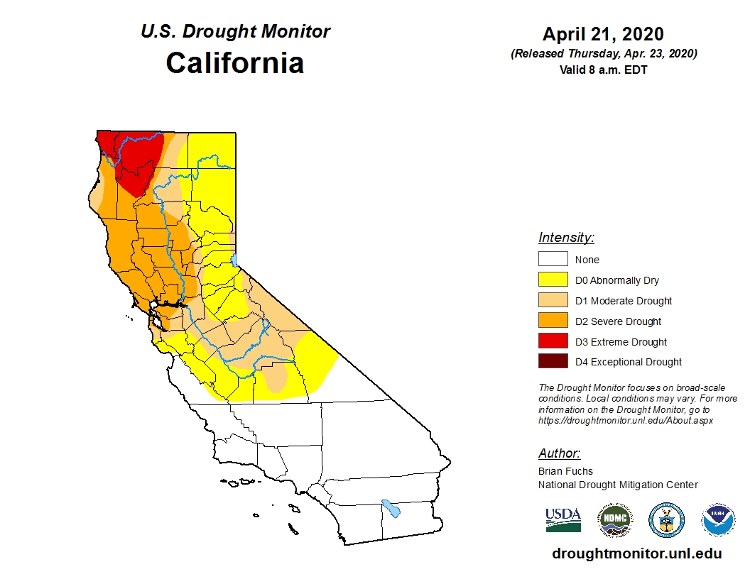
In NorCal, though, conditions could not have been more different. Exceptional and in some cases record-breaking dryness continues across the northern third of the state, as it has since last autumn, and more moderate but still anomalously dry conditions extend southward to about the San Francisco Bay Area, the Central Sierra Nevada, and points northward. Recent rains were generally meager north of the Monterey Bay Area (outside of a few isolated downpours), and across much of NorCal the cumulative seasonal deficit has actually continued to grow in recent weeks. Statewide snowpack is currently around 56% of historical averages for the date–which, although quite low, actually represents a substantial improvement over the abysmally low values in February.
I haven’t brought out the Drought Monitor graphic in a few years, but this week’s update is noteworthy as it shows a large portion of NorCal is currently experiencing “severe drought” conditions, and a subset of that region “extreme drought” conditions–the second highest category. One thing to keep in mind is that the DM is not an entirely objective metric–there is subjective human input (based on reported on-the-ground impacts) that goes into making drought determinations, as well as objective indicators such as precipitation deficits and soil moisture levels. So while I wouldn’t read too much into the week-to-week variations in the DM as California heads into the dry season, I do think it’s a useful indicator that the dryness up north is starting to have real impacts.
One consequence of this continued extreme dryness in NorCal is that the fire season will likely begin much earlier than last year (which had a pretty late start, due to a relatively wet and late spring). In addition, the NIFC is predicting a higher than average likelihood of large wildfires across NorCal by mid-summer–and I would expect that ultimately to be true into the autumn as well. SoCal may be a bit of a different story, given all the late rains and recent cool temperatures–I would not expect an exceptionally early start to the fire season down south (although hot and dry conditions this week could act to reverse some of these soil moisture gains).
Major early season heatwave in SoCal
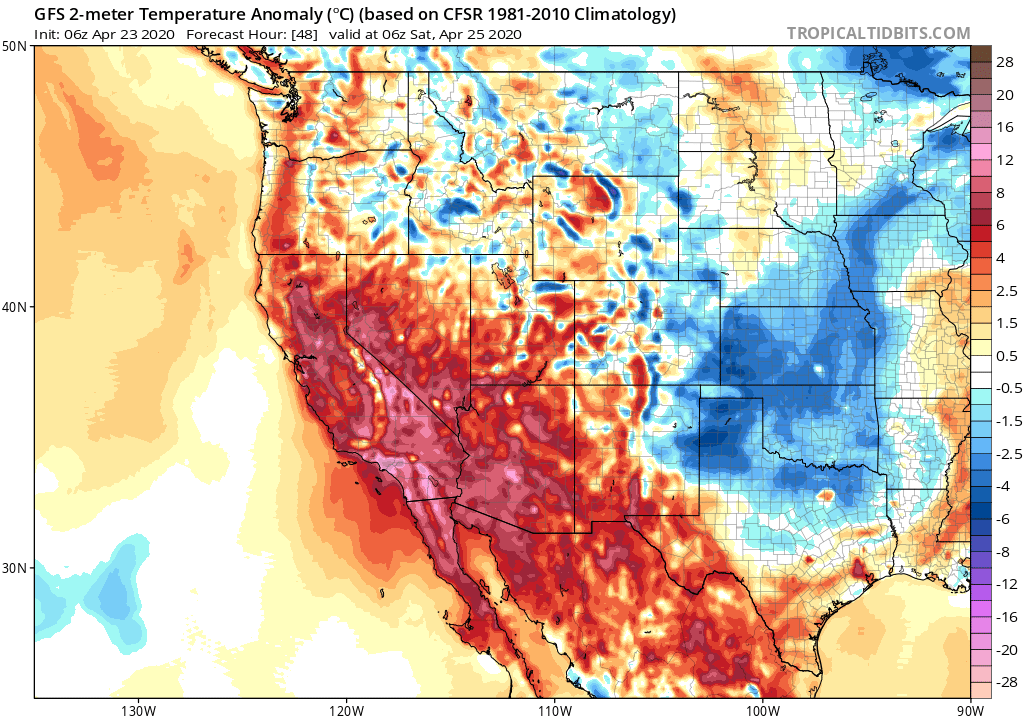
As I type this, things are already heating up across coastal SoCal this afternoon. And the heat will continue to build, peaking Friday and Saturday but remaining elevated well into next week. Daily record high temperatures are possible, especially Friday, when even places relatively close to the ocean could exceed 90F. While this heat is not exceptional by mid-summer standards, it’s important to keep in mind that it’s still April–and that many folks are currently stuck indoors (in many cases, without air conditioning). Given the earliness of the season and the limitations imposed by pandemic-related “stay-at-home” public health measures, this SoCal heatwave may have a higher impact than it would under other circumstances.
While it will be warm with well above average temperatures in NorCal, the heat will not be as pronounced or anomalous as in SoCal. Widespread 70s and 80s can be expected, however, which will still likely be among the warmest temperatures of the season to date. While vegetation dryness is not yet at critical summer/autumn levels, it is running much lower than usual for the time of year in NorCal and I would not be surprised to see an uptick in fire activity this weekend and next week as temperatures rise.
Dry and relatively warm through early May
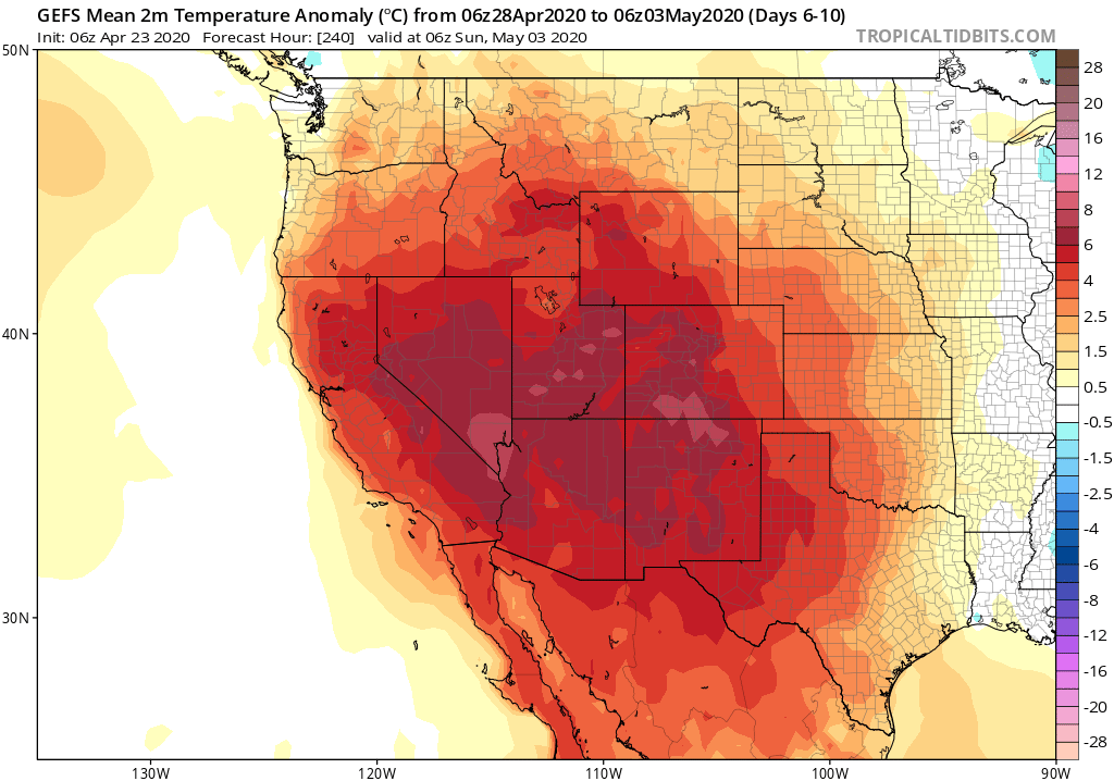
After this weekend’s heatwave in SoCal, multi-model ensembles are suggesting a pretty quiet pattern heading into early (and even mid-) May. Little if any precipitation is expected across California over the next two weeks, outside of the possibility of a few scattered mountain showers at times. That’s not all that unusual for the time of year–May and June are often the most “benign” weather months of the year for much of the state. Temperatures will probably run somewhat above average during this period. But the good news is that things will cool down relative to this weekend, and there are not any additional major heatwaves on the horizon at this point.
Early season heatwave in SoCal; drought intensifies in NorCal Read More »