Wrap-up of California’s dry/warm winter; “May Gray” along the coast and persistent mountain showers continue
2017-2018: The year of “March Mitigation”
Most of California was on track for one of its driest winters on record as recently as February as a result of persistent (one might even call it resilient) high pressure ridging along the West Coast during the first half of winter. Recall that December 2017 featured the largest wildfire in modern California history, following on the heels of the most destructive and deadly wildfire event in the state’s history just months earlier in October. Through late February, Sierra Nevada snowpack was tracking near its lowest level in recorded history–on par with the near-total snow drought of 2014-2015.
Then came March, and with it an unexpectedly persistent sequence of cold, wet storms across the northern 2/3 of the state. While this storm parade did not drop as much rain or mountain snow as the fabled “Miracle March” of 1991, it certainly provided a rather dramatic boost to mountain snowpack and surface runoff across much of the state. In some ways, the sudden shift to relatively cool (and even–gasp–below average!) late winter temperatures was even more striking than all the precipitation.
Given our recent streak record-breaking winter warmth in California, even a month-long reprieve was much-welcomed (and much discussed). This “March Mitigation” saved ski season for many folks, and prevented 2017-2018 from ultimately become a direly dry year across most of California.
More recently, most of California has entered a rather typical spring pattern characterized by a deep, persistent coastal marine layer–leading to near (or even below!) average temperatures and occasional drizzle along the immediate coastline over the past couple of weeks. Meanwhile, a rather persistent series of weak low pressure systems have been dropping down the West Coast just inland of the Pacific coastline, bringing periods of pretty widespread convective shower and thunderstorm activity to the Sierra Nevada and other higher-elevation areas in NorCal.
Believe it or not, 2017-2018 was a very warm, very dry season by historical standards
The chilly ocean air has been the talk of the town in both LA and SF in recent weeks, and I’ve even heard a few folks mentioning the “wet winter” experienced in NorCal this year. But just how do the temperature and precipitation stats stack up? How do the data from thermometers and rain gauges compare to our perceptions?
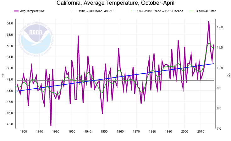

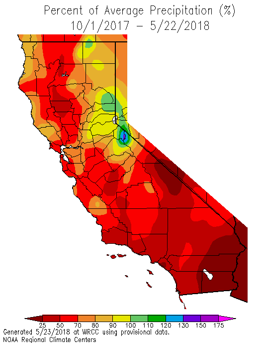
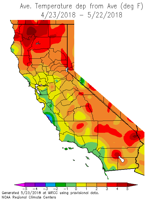
Well, despite the conspicuously cool and wet March–and our presently gloomy May skies–California actually experienced a very dry, very warm winter by historical standards (and this spring is also shaping up to be drier and warmer than average in most spots). October-April 2017-2018 was the fifth warmest such period since at least the late 1800s; and despite cool air along the immediate coastline (where, admittedly, most people in California actually live), the vast majority of the state has experienced above average April-May temperatures. October-April also featured far below average precipitation across nearly the entire state. This season has been particularly dry across Southern California–and is currently the third driest on record since 1895. This very dry season falls immediately on the heels of one of California’s wettest years on record just last year. In my last blog post, I discussed our recent research on the projected increase in California “precipitation whiplash” as the climate warms and the concentration of regional precipitation into a shorter, sharper rainy season–two trends that appear to be on full display this decade.
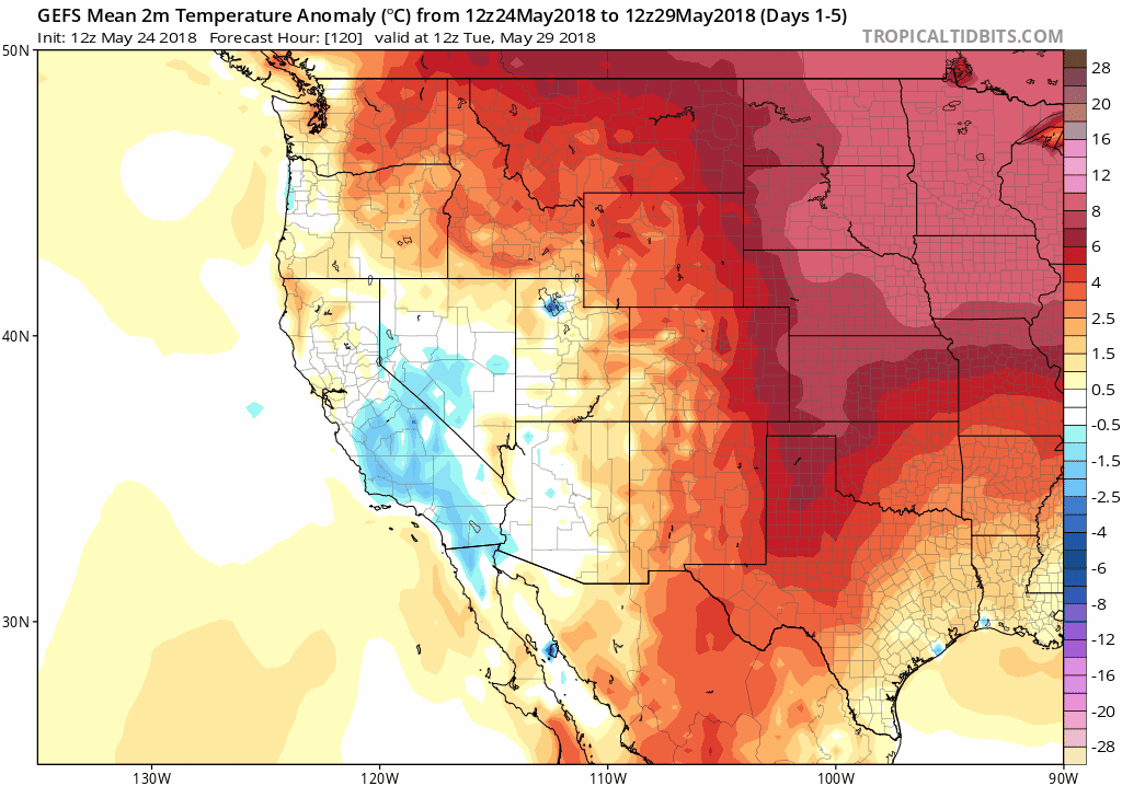
May showers possible across most of NorCal, then warmer temperatures across most of state
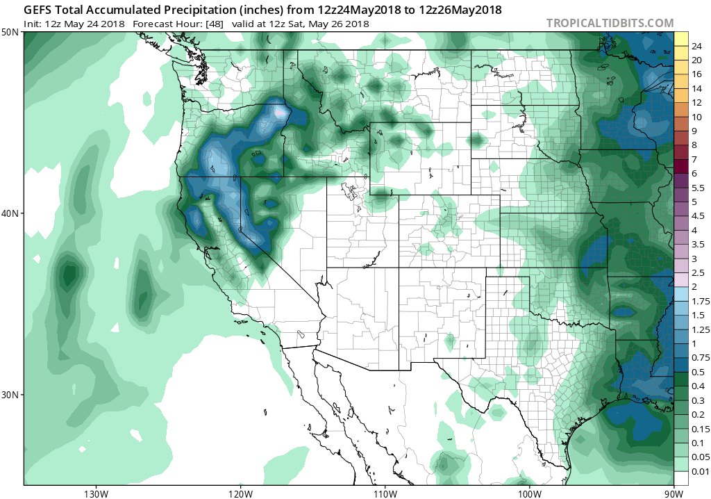
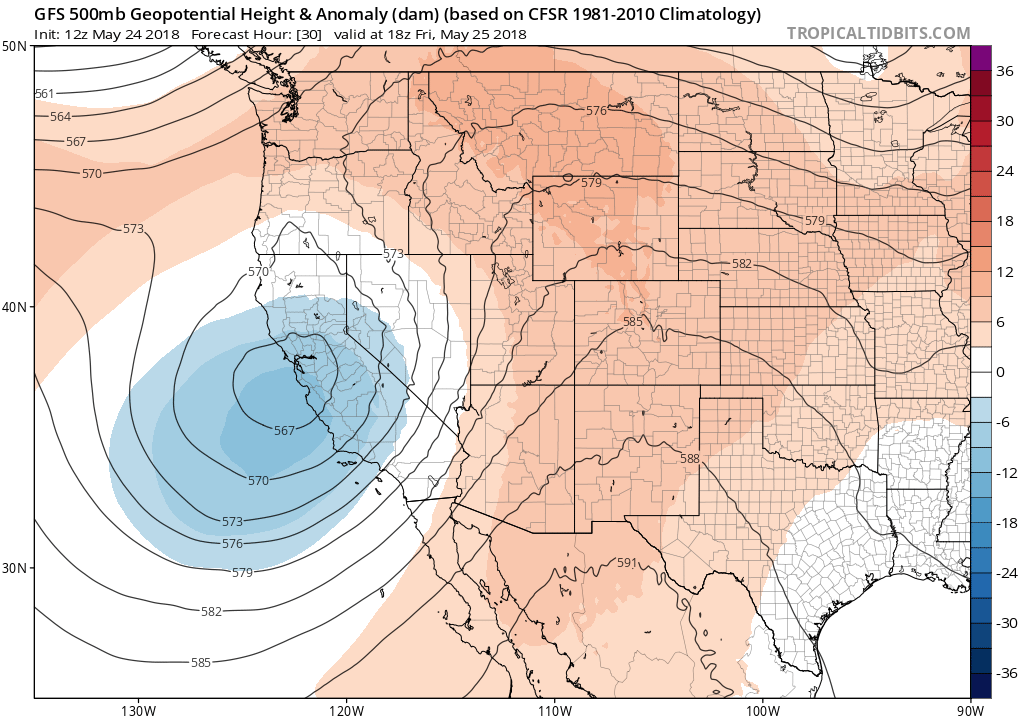
A weak low pressure system is currently approaching the NorCal coast from the west (as is readily apparent on satellite imagery), and will approach San Francisco on Friday. While this system is not very strong, and is relatively moisture-starved, there will likely be enough instability to generate fairly widespread convective precipitation (showers and thunderstorms). Unlike recent days, some of these may not be confined to the mountains, and there is at least a chance of some showers/isolated thunderstorms across the Bay Area and Central Valley. Unfortunately, Southern California will almost certainly remain dry outside of some more coastal drizzle from the deep marine layer. Meantime, in the Sierra Nevada, there will be the potential for some rather widespread/intense thunderstorms with a strong spring sun angle contributing to atmospheric lapse rates.
After this system departs later in the weekend, a rather dramatic warm-up is expected statewide (but especially across NorCal). Widespread 80s and 90s will feel pretty toasty compared to the recent relative chill. Thereafter, there’s a bit of uncertainty regarding whether another weak low may bring some renewed cooling; in the 7-14 day period, though, there’s a pretty robust model ensemble signal for considerable warming statewide. There are not yet any huge heat waves on the horizon–although recent solutions are suggesting that a pretty strong ridge could begin to build across the interior West in coming days that could eventually portend some early-season heat. For now, though, enjoy the relatively comfortable (and fairly typical) spring-like conditions.