Major and prolonged heatwave develops by this weekend over CA & Southwest; Record temperatures possible in San Joaquin Valley
Remarkably mild start to summer will be a (not so distant) memory by this weekend
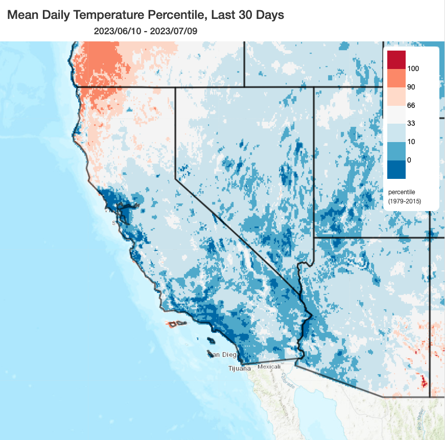
As many have noted, the coastal parts of central and southern California have been remarkably cool since about January. After a brief warmer lull in the late spring, anomalous coolness once again pervaded most of California during June. In fact, it appears that some areas along the immediate coast near the SF Bay Area and the SoCal metro areas (which, as I often point out, is cumulatively where the vast majority of Californians actually live) just experienced their coolest June since at least the late 1970s (a remarkable achievement in a rapidly warming climate globally).
Speaking of that rapidly warming Earth: in great contrast to recent temperatures in California, the last week now appears to have been the warmest week on record globally–blowing well past previous records as record-shattering marine heatwaves in both the Atlantic and Pacific as well as record-breaking terrestrial heatwaves in regions ranging from the Canadian Arctic, Southern Europe and northern/eastern Africa, as well as parts of SE Asia persist.
Severe & prolonged heatwave focused across the SW interior, including CA Central Valley & SE deserts, peaks this weekend
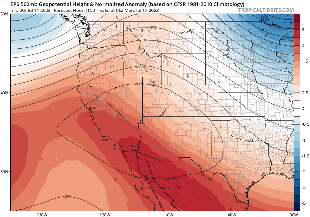
Well, that anomalous coolness in California is rapidly disappearing as I type–a very strong and highly anomalous (2-3 standard deviation 500mb GPH anomaly) is expanding and deepening across the interior Southwest. Hotter and drier air aloft is making its way westward from the Desert Southwest, where Phoenix is likely to break (potentially by a wide margin) its record for the greatest number of consecutive days at or above 110F. As this ridge expands and strengthens, a major heatwave will develop from south to north across California into this weekend. Each day will likely be hotter than the last starting tomorrow across the CA interior, with temperatures peaking between Saturday and Monday in most spots.
This will not be an extreme heatwave along the coast–the coastal parts of the SF Bay Area and Los Angeles/San Diego metros will certainly be warmer than usual, though not very hot. The marine layer will still be greatly suppressed, so expect a minimum of coastal fog and genuine t-shirt weather even in the usual coastal cool spots. But you won’t have to go very far inland (only 10 or 15 miles) to see a dramatic increase in temperatures–so this will be a very “inland-aligned” heatwave (common earlier in the summer, unlike “coastally-aligned” events in autumn). Record temperatures are therefore unlikely in this pattern along the coastal plains.
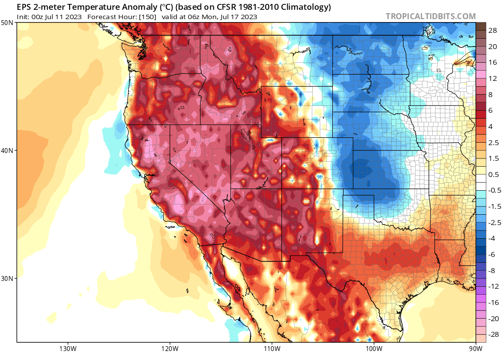
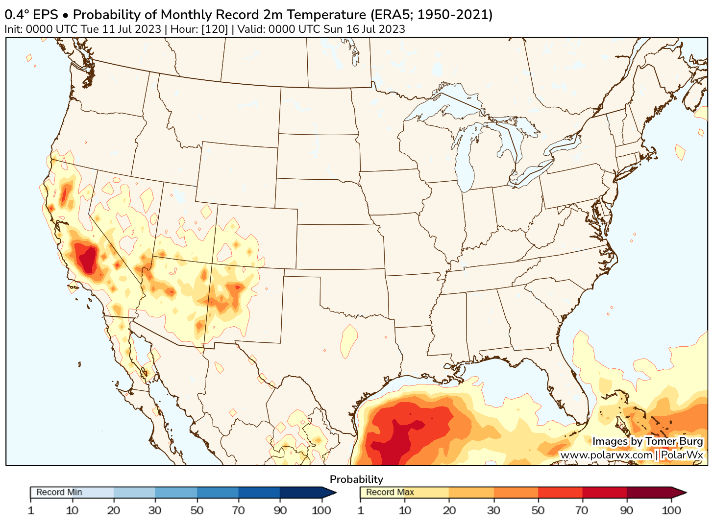
On Sunday and Monday, however, numerous calendar date record high temperatures will likely be tied or broken across the Sacramento (locally 110F+) and San Joaquin (locally 115F+) Valleys, as well as the southeastern deserts (Palm Springs will hit 120F+). Additionally, the ECMWF ensemble is suggesting a relatively high probability that some places in the San Joaquin Valley could reach or exceed *all time* temperature records on Sunday, which are generally in the 114-118F range in that part of the state. One searing statistic: the official recording site in Death Valley has a decent chance of tying (or even) breaking its all-time record high temperature of 130F. If that happens, expect a fair number of news headlines since that also happens to be the single hottest reliably recorded temperature on Earth. Whew.
Adding to the growing risk of heat-related illness in this event will be very warm overnight minimum temperatures in many inland areas. In fact, temperatures will fail to drop below 70F or even 80F at night in some parts of the Central Valley, adjacent foothill thermal bands, and deserts/interior valleys of SoCal. This likely means record-warm overnight minimum temperatures may be set over a wider region than daytime record highs, and this will also amplify heat risks for humans and animals.
One other note: since this event is expected to bring a long duration of extreme and potentially record-breaking heat to the San Joaquin Valley in particular, it is worth noting that this part of the Valley is much moister than usual for the time of year. In fact, there is still active inundation/flooding ongoing near/within the Tulare Lakebed. This may potentially shave a degree or two off of daytime high temperatures in the most affected locations, but could also keep overnight temperatures even more elevated and add some unwanted humidity to the daytime heat–potentially elevating heat indices above what they normally would be during an otherwise “dry” heatwave.
Finally, this will be a weather pattern favorable for plume-dominated where fuels have sufficiently dried out (which isn’t everywhere, but is increasingly the case in SoCal and at lower elevations in NorCal). This will also be true in adjacent states, so I’d expect an uptick in wildfire “initial attack” by this weekend and probably a few new large fires somewhere in the SW by early next week. I still don’t foresee extreme fire conditions on the docket at the moment (and, indeed, vegetation moisture levels are still conducive to prescribed fire treatments at higher elevations and north-facing slopes, esp. in NorCal, due to our cool/wet winter/spring!), but this event probably will result in a notable uptick in activity.
Unusually hot weather may persist through late July in many inland locations
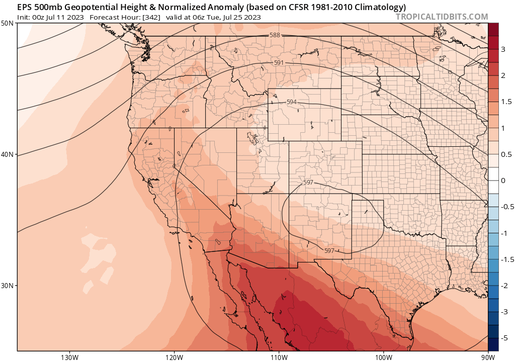
Unlike heatwaves thus far this season in California, which have been transient and not notably extreme, this one will only gradually fade by the middle of next week. Thereafter, there are actually signs that another uptick in notable to extreme heat may occur across the Southwest (including much of CA away from the immediate coast). So although there will very likely be a cool down from record high temperatures this weekend around next Tue/Wed, things could potentially pick back up again after that as a persistent and strong ridge appears likely to become anchored over the SW (and occasionally expanding/extending westward over CA). It’s too early to know the magnitude of heat-related impacts more than 7-10 days in the future, but it’s likely that wildfire season will continue to heat up out West and human health-related impacts may start to increase as well. Additionally, the SW monsoon appears likely to be delayed at least for another week or two–which would be in line with predictions of a weaker/later than usual seasonal wind reversal this year. Stay tuned!