Slow-building heatwave across interior; possible very hot end to July with fire season accelerating
A refreshing start to summer in California, especially up north
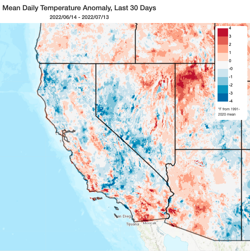
May and June 2022 (as well as the first week in July) were notably mild across much of California, for the most part. Late-season precipitation kept things fairly damp across much of the northern third of California through late June, and unusually persistent troughiness (likely thanks to the ongoing and now record-strength for mid-summer La Niña event) kept heatwaves relatively few and far between. This helped suppress early-season wildfires across much of the state, although activity has recently picked up and 100/1000 hour fuels (heavy brush/dead and down tress) are now at or near record dry levels once again.
As noted earlier in the summer outlook, this mild weather reprieve was unlikely to last all summer–and indeed it does now appear that California (and the rest of the West) is likely in for a major pattern change over the coming days. I discuss the details below.
Huge high pressure ridge shifts westward and intensifies, bringing building Western heat (away from coast, at least)
It’s not unusual to have a strong high pressure system anchored somewhere near the Four Corners of the interior Southwest in mid-summer–it’s a keystone feature of the seasonal climate in this part of the world, and a driver of the critically important North American Monsoon. But in the coming days, this typical climate feature is expected to intensify considerably beyond typical levels and expand well beyond its usual geographic extent–eventually encompassing nearly the entire western 2/3 of the continental U.S. (from the Great Plains to the Pacific Coast by the end of July). This is a fairly remarkable pattern in that it has the potential to bring not only widespread well above average temperatures, but also the potential to suppress drought-mitigating precipitation from the summer monsoon across the interior Southwest.
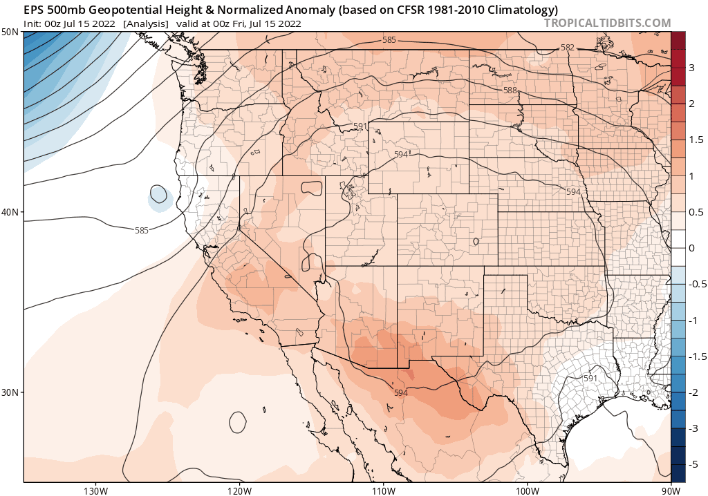
Right now, there is strong multi-model ensemble agreement that the Western ridge will become anomalously broad and strong in the coming days, and that this will be a very persistent pattern–likely lasting at least 2-3 weeks once it become entrenched. Therefore, a very prolonged (2-3+ weeks in some areas) period of very hot conditions can be expected from the Plains states to the interior West. This, in combination with the subsequent suppression of monsoon precipitation, will probably push fire season into high gear across the interior Western forests that have already been suffering from extreme to unprecedented drought. It is also, decidedly, not great news for the Colorado River Basin–where the water crisis is now rapidly worsening.
At the moment, I do not expect California to be at the epicenter of this heatwave–while record high temperatures are likely in some other parts of the U.S. with this event, they are somewhat less likely during this event in California. I also believe that the coastal areas will continue to see only modest warming, consistent with the preferred inland-focused “heatwave mode” for June-August mentioned in the seasonal outlook this year. But there are some hints in the ensemble that more severe heat outcomes are possible during this event–especially across the Central Valley and northern/central mountains & foothills. We shall see; I’ll be updating on Twitter in the meantime.
There will likely be a break in the heat across interior California toward the end of next week, in between waves of high pressure strengthening. Temperatures may briefly fall down to near-average levels across the Central Valley/Sierra Nevada for 2-3 days at that point. But the second wave of this heatwave will arrive soon after–there is fairly remarkable ensemble agreement on that point for being so far in the future.
So, to summarize: there will be a prolonged and locally intense heatwave across all of western North America in the coming weeks, though it may be less intense in California (especially near the coast, though with some uncertainty, especially toward the end of the month). This heatwave will likely be more remarkable for its spatial extent and duration rather than its maximum intensity, in most places.
But this stands in pretty stark contrast with ongoing extreme heat events elsewhere in the Northern Hemisphere at this moment–where numerous places are setting all-time heat records. Parts of the southern U.K., for example, are now officially forecast to experience to experience astonishingly hot temperatures approaching or even exceeding 40C (that’s 104F!) early next week–shattering all existing records. Much of the rest of western Europe will experience similarly extreme heat, and China has also been enduring exceptional temperatures in recent days. So in context, the upcoming U.S. event will (despite being fairly remarkable) be the least extreme such event currently ongoing across multiple continents.
Consistent with earlier predictions, the second half of summer is looking quite different from first half
As discussed above, the late July and early August period are already looking starkly different from the May through early July period across California, with much hotter conditions (including the potential for prolonged well above average temperatures across the interior). Seasonal and sub-seasonal projections suggest that general pattern–of greatly elevated inland heat (beyond typical summer levels) with more moderate conditions right along the coast–will likely continue through at least August. Anomalous strong ridging is favored over the interior West through early September, so I would expect to see substantially more episodes of intense heat in the second half of the summer this year than the first (and that is not always the case!).
Also of note is that La Niña continues to overstay its welcome–it was recently pegged at the strongest level on record for mid summer! Unfortunately, all signs point toward this ongoing La Niña event evolving into a so-called “Triple Dip” event, where anomalously cool ocean temperatures in the eastern tropical Pacific Ocean persist into a third consecutive year. It’s a little too early to discuss implications for autumn and winter conditions, but I do expect La Niña teleconnections to be a major player heading into the coming 2022-2023 Water Year (yes, once again). Stay tuned.