Semi-active winter pattern likely across NorCal, but magnitude of pattern change uncertain (and good riddance to 2020)
2020 in California weather, wildfire, and otherwise: good riddance!
Let’s just face it: 2020 has been a truly awful year in California–weather-wise, and otherwise. California suffered its worst wildfire season on record, by an enormous margin, in the midst of a worsening pandemic. Dozens were killed by the fires themselves, and thousands lost their homes; over a million were evacuated at some point over the past 6 months; and nearly all of California’s 40 million residents suffered through prolonged, historically unprecedented “smokestorms” that produced turned the sky Blade Runner orange.
The fire siege of 2020 brought about Sierra Nevada firestorms of such intensity that they produced enormous, rotating pyrocumulonimbus clouds that produced their own lightning and violent, swirling updrafts that reached the stratosphere (as more commonly occurs during major volcanic eruptions)–and the National Weather Service subsequently issued its first two “pyrotornado” warnings on record.
2020 also brought all-time record heat to California–August, September, and October were all the warmest such months on record. A number of specific locations along the coast in Southern California experienced their singularly hottest days on record. 2020 was also among the driest calendar years on record for much of Northern California.
And it remains impossible to ignore the background context of the COVID19 pandemic–which, in addition to wreaking widespread economic and societal disruption, has already killed far more Californians than all earthquakes, wildfires, floods, and storms in the 20th and 21st centuries…combined.
I think most folks will join me in bidding good riddance to this godawful year.
A Pacific jet extension–but what does this mean for CA?
In the short term, the California weather outlook is…mixed, and more than a little uncertain. There has been much buzz regarding the potential for a major pattern change that would favor much wetter conditions over California. And while early hopes have been tempered somewhat, I do still expect at least a 7-10 period of more active weather across NorCal. But as it often is: the devil’s in the details.
The long-advertised Pacific jet extension appears to be well underway, and yesterday supported the explosive “bombogenesis” of an extremely deep low pressure center near the Aleutian island chain. This system apparently became the *strongest extratropical cyclone on record* in the North Pacific basin from a central minimum pressure perspective–a testament to the strength of the polar jet now screaming across the west and central Pacific. Now, the perennial challenge in California is: how far east will the Pacific jet extension actually make it across the vast Pacific Ocean, and when it comes ashore along the West Coast, will it be far enough south to benefit CA? The answer remains…foggy. Earlier model ensemble solutions had suggested that the jet would be strong enough and far enough south to support widespread heavy precipitation across NorCal heading into the first week of January. More recent solutions have backed off considerably, though still suggest that multiple moderately strong systems are likely to affect NorCal over the next 10 days or so and bring some widespread rain/snow from about the SF Bay Area northward.
The ECMWF is still somewhat wetter than the GFS, but both have converged on a scenario that would feature several bouts of light to moderate precipitation across drought-parched NorCal–which is good news, on balance. None of these storms appear likely to be exceptional at this point, but they may at least be enough to increase baseflows on some parched river systems and bulk up a Sierra Nevada snowpack that (as of yesterday) was only around 52% of average for the date. Right now, it certainly does not appear that any of these will pose a major threat of flooding. If the wetter ECMWF solutions pan out, there may be a modest risk of debris flows in some of NorCal’s fire-affected regions (although as we saw in Montecito back in 2018, sometimes it only takes a very localized downpour at the wrong place/time to cause big problems–so folks should be prepared throughout the coming winter regardless).
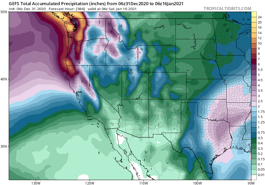
Right now, it looks like precipitation across NorCal will likely be able to “keep pace” with average level for the early Jan period–but probably won’t chip away at the already very large cumulative deficits from 2020. Across SoCal, precipitation may be quite sparse once again over the coming 2 weeks (although this region, at least, did finally receive a widespread soaking earlier this week).
Unusually high uncertainty for much of January due to polar vortex disruption
Uncertainty may be even higher for the latter portion of January and beyond. A key reason for this is an anticipated major disruption of the stratospheric polar vortex in the coming days–a fascinating and very complex process that contemporary weather models are still not great at capturing in many instances. Right now, it appears that the stratospheric vortex will likely be destabilized and possibly split into two lobes–but implications for tropospheric impacts (i.e., those in the lower part of the atmosphere where we live) are notoriously hard to predict.
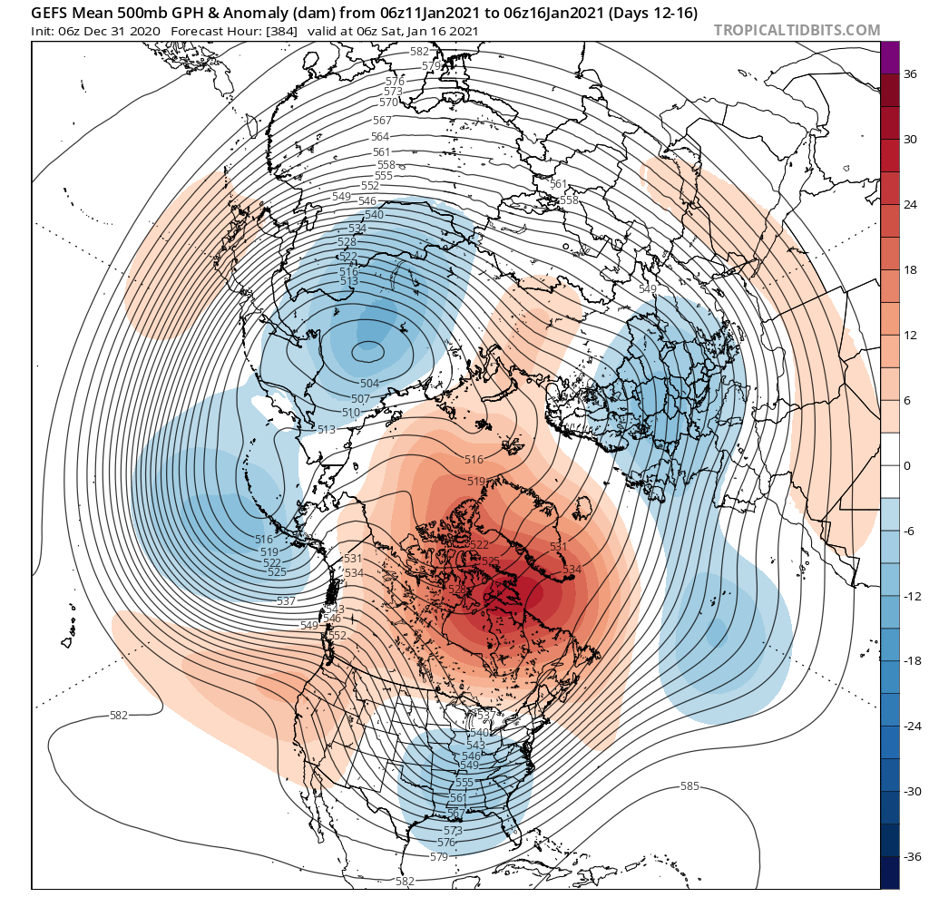
At the moment, sub-seasonal models and long-range ensembles suggest that a persistent high-amplitude wave pattern is possible across the Northern Hemisphere from around January 10th and persisting for the rest of the month. But the exact phasing of this possibly very persistent ridge-trough sequence is currently and will likely remain quite uncertain for days to come–until the PV disruption actually occurs. That will largely dictate whether California continues to experience anomalous ridging and unusually dry weather or finally sees a shift toward consistently more active and winter-like conditions later in January. At this time, the models are favoring a persistent North Pacific ridge that would keep California pretty dry–but this is a very low confidence prediction. Succinctly summarized: ¯\_(?)_/¯ .
Here’s to a better 2021.