Pair of major “Pineapple Express”-type atmospheric rivers to affect California Wed-Mon; elevated flood and wind risk (especially from storm #2)
Record warmth this week will suddenly give way to pair of major storms
Well, I’ll keep this section short since there’s a lot to talk about! But most of California and indeed much of western North America has been experiencing record mid-winter warmth since the weekend–and although it’s hardly the only time California has seen multi-day stretches with record-breaking temperatures in recent years, it’s worth noting just how ho-hum these kinds of records have become as our winters continue to warm. It’s especially notable given that San Diego County saw record-breaking rainfall and severe flash flooding just last week, and that large portions of the state will be at risk of additional flooding in the coming days (with the sunny days in the 70s and locally even 80s sandwiched in between).
Storm #1 on Wed-Thu will arrive in form of warm, wet “Pineapple Express”
There will be two separate major storm events in the next 7 days in California, and I’ll address them each separately. The first will arrive in NorCal on Wednesday and sweep across SoCal on Thursday. This system will feature a strong atmospheric river of the “Pineapple Express” variety: it has a clear connection to subtropical moisture along a moisture transport axis extending southwestward to the Hawaiian Islands. Unsurprisingly, then, this storm will be very warm and wet in its initial stages (with high snow levels, locally very heavy downpours and isolated thunderstorms, and possibly some strong, gusty winds in NorCal). It does appear that colder air on the backside of the storm will drop snow levels considerably (below pass level and hopefully at least down to Lake Tahoe level) early enough to allow for some meaningful snow accumulation, though, later in the event.
This system has the potential to bring a 6-12 hour period of heavy to locally very heavy rainfall in NorCal on Wednesday, especially if a frontal wave can develop right as the cold front approaches the SF Bay Area (as some models are indicating). Widespread roadway and small stream flooding is likely in NorCal on Wednesday, and some smaller/faster responding rivers could potentially even briefly exceed flood stage (though probably not by a huge margin). The wildcard with such systems is always whether there’s any unpredicted stalling of the very moist frontal band; if that happens, a 50-100 mile wide corridor has the potential to see some elevated flood impacts.
This storm will hold together pretty well as it moves across SoCal, and so I expect widespread rain (heavy at times, especially mountains) on Thursday. Roadway and small stream flooding is possible in SoCal with this first event as well (though probably not major flooding), and some isolated thunderstorms/heavy downpours are plausible as well in a marginally unstable subtropical airmass.
Storm #2 on Sun-Tue details TBD, but also looks warm/wet & has higher ceiling on flood risk (esp. SoCal)
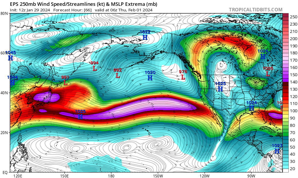
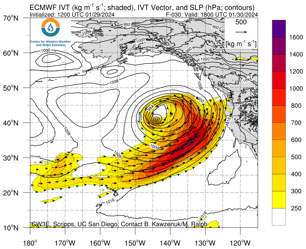
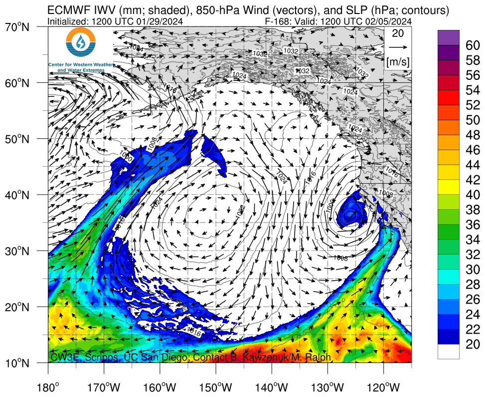
Storm #2, which will likely arrive on Sunday but may linger into Monday or even Tuesday, is still a little more uncertain but has a considerably higher ceiling in terms of rain (and wind) impacts–especially in Southern California. This system will be positioned in an ideal configuration, relative to the screaming Pacific jet stream overhead, for rapid deepening of a surface low (or even a pair of surface lows) offshore. Additionally, this will be a low-latitude system and will be capable of tapping into not only subtropical moisture (as with the Wed storm) but maybe even deep “true” tropical moisture–which is pretty rare for California wintertime storms.
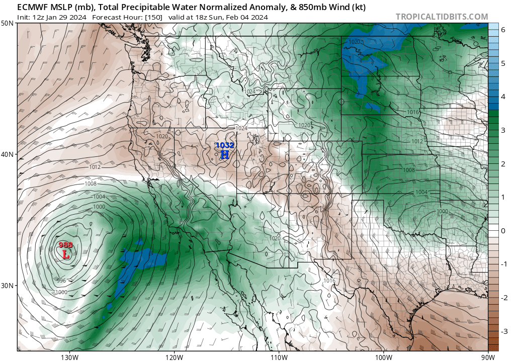
All of the ingredients–a strong, cyclonically curved jet overhead, a rapidly strengthening surface low, a deep subtropical (tropical?) moisture tap, and even some notable surface-based instability–will be in place for a potentially very high-impact storm on Sun-Mon. The details remain fuzzy, but a substantial number of the ECMWF ensemble members depict the potential for widespread very heavy precipition throughout most or all of Southern California (and possibly also Central CA as far north as the SF Bay Area) during this period along with the potential for locally damaging winds at times as the strong surface low approaches.
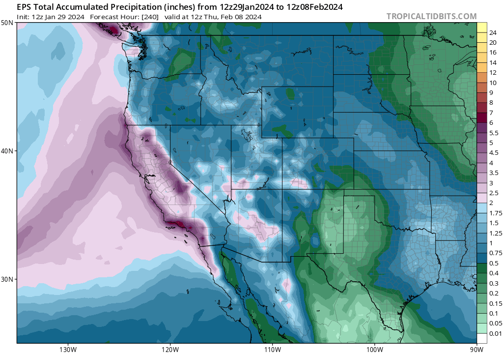
Will all these ingredients come together in the right spatiotemporal sequence (i.e., with the “proper phasing”) to generate a very strong/very wet storm somewhere in the southern half of California Sun-Mon? It’s too early to be entirely certain, but the odds are moderately high and increasing that some portion of the CA coast between San Diego and Monterey Bay will experience a very heavy rain event during this interval. There are some ECMWF ensemble members that depict over 10 inches near and along the Los Angeles coastal plain between Wednesday and Tuesday–just a 6 day period!While I don’t think it’s the most likely outcome, it is possible–and if it occurs, widespread and possibly serious flooding would occur across much of Southern California (not just in the mountains, but likely elsewhere as well). That outcome appears to be most likely if 1) the surface low develops near the coast and becomes quasi-stationary in a position that stalls a warm AR/cold frontal band over the Transverse Ranges of SoCal for 24 hours or more, and/or 2) if the system can tap into the deep tropical moisture reservoir (as the ECMWF currently suggests), which could generate a pretty unstable and record-moist airmass, perhaps leading to strong or even locally severe convection (thunderstorms) with embedded training cells (leading to locally major flash flooding).
It is worth noting that two locations in Southern California–Ventura back in December and San Diego just last week–have already experienced record-breaking hourly to daily-scale precipitation and severe flash flooding due to somewhat localized but extreme thunderstorm downpours this winter (each caused by the presence of an unusually warm and unstable atmosphere with a strong jet streak in just the right position overhead). With this upcoming pattern in SoCal, there is the potential to break yet more precipitation records and perhaps even in a more widespread fashion–which is concerning partly because soils in parts of SoCal are still pretty saturated following recent downpours (despite recent record warmth). That’s quite a sequence!
Right now, I am most concerned about the potentially significant flood risk from storm #2 in SoCal, but recent model runs have suggested that the precipitation and wind risk could also spread somewhat farther northward toward the SF Bay Area. It’s difficult to know at this point which section of coast will see the greatest impacts Sun-Mon, but the details should become clearer in the next couple of days.
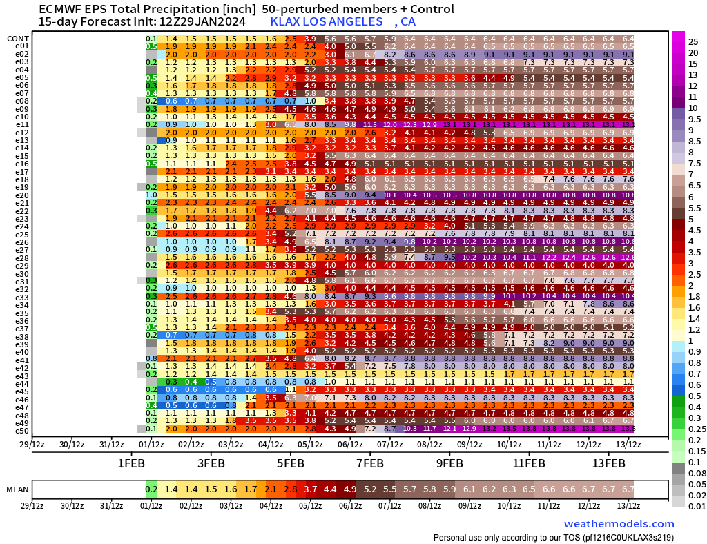
I’ve included the meteogram below (from the ECMWF ensemble and for a point near Los Angeles International airport) just to give a sense of the range of rainfall accumulations that are possible in coastal SoCal over the next week. The mean is already quite high–nearly 7 inches–but about 10% of members are depicting over 10 inches of rain during the same period along the SoCal coastal plain (!). For perspective, the average annual rainfall in Los Angeles (in lower elevation portions of the city, at least) is around 12-15 inches (depending on observing site and period of record), so there are a couple of ECMWF members depicting the city receiving nearly 100% of the annual average rainfall in a 5-6 day period (!). Again, that is not the most likely outcome, but this is an illustration of what is physically possible when a record moist airmass, unusually warm ocean temperatures, and a favorable synoptic weather pattern potentially align.
A note about El Niño and the seasonal outlook
I won’t spend too much time belaboring the point here, because there’s more important stuff to discuss in the short term. But even assuming the ensemble average of predicted precipitation over the next 10 days, it’s likely that much of central and southern California will end up well ahead of average precipitation for the winter to date–and perhaps even above average for the entire winter season–by the end of this relatively brief storm cycle. This very wet pair of storms, enhanced by a strong and southward-shifted jet and an exceptionally moist airmass/warm coastal sea surface temperatures–is a classic strong El Niño-like pattern. It would be genuinely striking if, over the course of a single storm sequence, if parts of southern and central California surpassed their winter seasonal average precipitation in a one fell swoop.
Join me live for YouTube office hours–three times this week!
I will be having (at least!) three scheduled YouTube live virtual office hours to discuss this upcoming storm sequence and its potential impacts (and may add in an additional one or two “pop-up” sessions if appropriate, which would mainly be if storm #2 ends up trending toward the wetter end of the ensemble envelope in SoCal).
Join me Tuesday Jan 30 (2pm Pacific), Friday Feb 2 (10am Pacific), and again on Sunday Feb 4 (also 10am Pacific) for these scheduled sessions!